

Министерство науки и высшего образования Российской Федерации Федеральное государственное бюджетное образовательное учреждение высшего образования
«Сибирский государственный автомобильно-дорожный университет (СибАДИ)»
Г.Н. Мусагитова, И.В. Бреус, СибАДИМ.В. Цыгулева
СТРОИТЕЛЬСТВО ДОРОГ – МОЯ ПРОФЕССИЯ
BUILDING ROADS – MY PROFESSION
Уче ное пособие
2-е изд., деривативное
Омск • 2019

УДК 811.111 ББК 81.432.1 М91
Согласно 436-ФЗ от 29.12.2010 «О защите детей от информации, причиняющей вред их здоровью и развитию» данная продукция маркировке не подлежит.
Рецензенты:
д-р филол. наук, проф. Л.О. Бутакова (ОмГУ); д-р филол. наук, проф. Н.В. Орлова (ОмГУ)
СибАДИсловарем, облегчающим ра оту с профессионально ориентированными текстами, также может быть рекомендовано для переводчиков в сфере профессиональной коммуникации (английский язык) в дорожно-строительной области.
Работа утверждена редакционно-издательским советом СибАДИ в качестве
учебного пособ я.
Мусаг това, Гал я Нильевна.
М91 тро тельство дорог – моя профессия = Building roads – my profession
[Электронный |
ресурс] : уче ное пособие / Г.Н. Мусагитова, И.В. Бреус, |
М.В. Цыгулева. – Электрон. дан. – Омск : СибАДИ, 2019. – URL: http://bek.sibadi.org/ |
|
cgi-bin/irbis64r |
plus/cgiirbis 64 ft.exe. – Режим доступа: для авторизованных |
пользователей. |
|
ISBN 978-5-00113-116-8. |
|
Тексты |
упражнения, представленные в пособии, направлены на развитие |
навыков чтения и говорения на английском языке. Снабжено терминологическим |
|
Имеет интерактивное оглавление в виде закладок.
Разработано для обучающихся всех форм обучения уровней бакалавриата, специалитета, магистратуры по дорожно-строительным специальностям и направлениям.
Подготовлено на кафедре «Иностранные языки».
Мультимедийное издание (635 КБ)
Системные требования : Intel, 3,4 GHz ; 150 МБ ; Windows XP/Vista/7 ; DVD-ROM ; 1 ГБ свободного места на жестком диске ; программа для чтения pdf-файлов :
Adobe Acrobat Reader ; Google Chrome ; Windows Media Player, колонки
Редактор О. . Соболева
Техническая подготовка Н.В Кенжалинова Издание второе, деривативное. Дата подписания к использованию 15.04.2019
Издательско-полиграфический комплекс СибАДИ. 644080, г. Омск, пр. Мира, 5 РИО ИПК СибАДИ. 644080, г. Омск, ул. 2-я Поселковая, 1
ФГБОУ ВО «СибАДИ», 2019

|
Ссылки внутри текста кликабельны |
|
FROM THE HISTORY OF ROAD BUILDING |
1. |
Discuss the following questions with your partner: |
1. |
What faculty do you study at? |
2. |
What qualification will you get after graduation? |
СибАДИ |
|
3. |
What specialized subjects are there in your curriculum? |
4. |
Do you read books on roads building? |
5. |
What do you know about the history of road construction? |
6. |
What is road engineering? |
2. Please insert the 32 words correctly to answer the last question in Ex. 1:
and • and • be • beginning • by • by • bystanders • difficult • has • land • lines • mobility • needs • needs • new • of • of • offered • people • pricing • problems • provision • sprawl • the • the • the • this • to • to •
|
|
|
|
|
|
|
|
||
transport • travel • with |
|
|
|
|
|
|
|||
|
|
|
|
|
Road engineering |
|
|
|
|
Since the |
|
|
|
1) of the 20th century, as |
2) auto- |
||||
mobile |
and |
truck |
have |
3) |
ever |
higher |
levels |
of |
|
|
4) vehicle ownership per head |
5) population has in- |
|||||||
creased. Road |
|
|
6) have been strongly influenced |
7) |
this |
||||
popularity and also |
8) the mass movement of |
|
9) to cities |
||||||
and thence |
10) suburban fringes – a trend that |
11) led to in- |
|||||||
creasing |
travel |
|
|
12) and road congestion and |
13) |
low- |
|||
density |
cities, |
which |
are |
|
14) to |
service |
by public |
||
______________.15) Often the building of |
16) roads |
to alleviate |
|||||||
such |
|
17) has encouraged further urban |
|
18) and |
|||||
yet more road _________.19) Long-term solutions require the
______________20) of alternatives to car _____21) truck transport, controls over ______22) use, and the proper __________23) of road travel. To
______24) end, road managers must _____25) concerned not merely with
________26) on maps but also ______27) the number, type, speed,
_____28) loading of individual vehicles, _____29) safety, comfort, and
3
convenience _____30) the traveling public, and _____31) health and welfare of _______________32)
3. |
And now you are going to get acquainted with the history of |
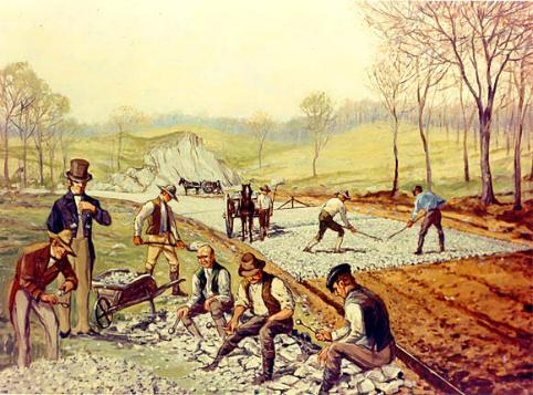
road building. But first, look at the pic. 1. This is the Boonsboro Pike, |
|
С |
|
the first Macadam Road in the US. What do you see in this picture? |
|
и |
|
|
б |
|
А |
|
Pic. 1 |
1. |
How did the first road look like to your mind? |
2. |
When was the first road built? |
3. |
И |
What were the first road building materials? |
|
4. |
Scan the texts about ancientДroads and find at the following map |
the countries where the roads described were built (pic. 2).
4
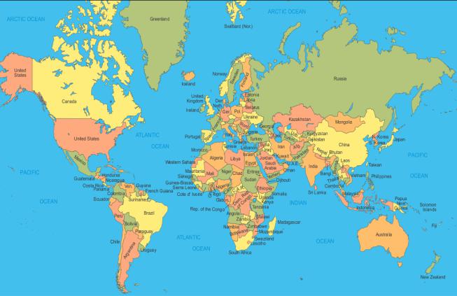
СибАДИhttp://geology.com/world/world-map.gif Pic. 2
4. Read the texts and try to find the answers you had difficulties with.
Ancient roads of the Mediterranean and Middle East
The first roads were paths made by animals and later adapted by humans. The earliest records of such paths have been found around some springs near Jericho, Israel and date from about 6000 BC. The first indications of constructed roads date from about 4000 BC and consist of stonepaved streets at Ur in modern-day Iraq and timber roads preserved in a swamp in Glastonbury, England. During the Bronze Age, the availability of metal tools made the construction of stone paving more feasible; at the same time, demand for paved roads rose with the use of wheeled vehicles, which were well established by 2000 BC.
Cretan stone roads
At about this time the Minoans on the island of Crete built a 30-mile road from Gortyna on the south coast over the mountains at an elevation of about 4,300 feet to Knossos on the north coast. Constructed of layers of
5
stone, the roadway took account of the necessity of drainage by a crown throughout its length and even gutters along certain sections. The pavement, which was about 12 feet wide, consisted of sandstone bound by a clay-gypsum mortar. The surface of the central portion consisted of two
rows of basalt slabs 2 inches thick. The centre of the roadway seems to С
have been used for foot traffic and the edges for animals and carts. It is the oldest existing paved road.
Roads of Persia
The earliest long-distance road was a 1,500-mile route between the Persian Gulf and the Mediterranean Sea. It came into some use about 3500 BC, but it was operated in an organized way only from about 1200 BC by
terraneanиports of Smyrna (Vzmir) and Ephesus. More a track than a constructed road, the route was duplicated between 550 and 486 BC by the great Persianбkings Cyrus II and Darius I in their famous Royal Road. Darius I made the Royal Road as it is recognized today by improving the road bed with a hard-packed gravelled surface, of 6.25 m width and held within a stone curbing at a stretch near Gordium, and connecting the parts together in a unified wholeАstretching some 1,500 miles. Like its predecessor, the Persian Royal Road began at Susa, wound northwestward to Arbela, and thence proceeded westward through Nineveh to Harran, a major road junction and caravan centre, and contained hundreds of stations for the exchange of horses. The Royal Road served many purposes including trade and the ability to dispatch troops when needed in recalcitrant prov-
the Assyrians, who used it to join Susa, near the Persian Gulf, to the Medi-
traversed the route in 20 days. Д
inces. The main road then continued to twin termini at Smyrna and Ephesus. The Greek historian Herodotus, writing in about 475 BC, put the time
for the journey from Susa to Ephesus at 93 days, although royal riders И
Babylon
Archaeologists have discovered that in Babylon the streets were laid out in straight lines that intersect approximately at right angles, an innova-
tion that bears witness to city planning and strong central government. There were 24 streets in the city, running either parallel to the river or
at a right angle to it. These streets were narrow, irregular, ranging from about four to twenty feet in width with high windowless walls on each side. The streets were not paved, with the exception of the Processional Way, but instead created with raw earth. Streets provided access to houses, temples, and public buildings. They also carried the burden of becoming
6
the dumping grounds for the city. The citizens of Babylon, not unlike those of Renaissance England, threw their garbage and filth into the streets. Then, they covered it up with layers of clay. As a result, the streets of Babylon began to rise, and eventually, houses needed to be built on higher ground.
СThe street known to the Babylonians as Aibur-shabu (the enemy shall never pass) was the name of the road leading from the north to the Ishtar
gate. It was a broad paved road that ran for 200m between high walls (the eastern wall of the northern palace and the western side of the eastern outer bastion).
innerиtown to a special festival house called the Bit Akitu situated to the north. The road climbs gently upwards towards gate. Center of the roadway was laidбwith huge flagstones of limestone, each paving stone has an inscription of Nebuchadnezzar's dedication. On leaving the gate, the Processional Way goes past the Southern Palace, sloping downwards then some 900 m south turns west between the ziggurat enclosure and the Marduk temple towardsАthe Euphrates bridge built by both Nabonidus and Nebuchadnezzar.
The most famous street was the “Processional Way” which ran along the
eastern side of the southern palace, through the Ishtar gate and outside the
The way was lined with figures of some 120 lions, the symbol of Ishtar in molded glazed bricks. The lions on the Ishtar gate have a dark blue background. They were either white with yellow mane or yellow with red manes (now weathered to green).
and temples led to the opening of manyДquarries in the low cliffs near the Nile River. To make it easier to transport the heavy stones from one of these quarries, the Egyptians laid what may have been the world's first paved road.
Egypt
In the Old Kingdom of ancient Egypt, a time of grand architecture be-
ginning about 4,600 years ago, demand for building stones for pyramids И
Research geologists mapping the ancient Egyptian stone quarries have identified a seven-and-half-mile stretch of road covered with slabs of sandstone and limestone and even some logs of petrified wood. The pavement, they concluded, facilitated the movement of human-drawn sleds loaded with basalt stone from a nearby quarry to a quay for shipment by barge across the lake and on the Nile to construction sites.
7
"Here is another technological triumph you can attribute to ancient Egypt," Dr. James A. Harrell, a professor of geology at the University of Toledo, Ohio, said in an interview. Report of Discovery Dr. Harrell and Dr. Thomas Bown, a research geologist at the United States Geological Survey in Denver, mapped the road last year and reported their findings on
СFriday at a meeting of the Geological Society of America in Durango, Colo.
They said that pottery fragments at a quarry and a camp for the ancient stone workers, both discovered near the road, helped date the site to the period of the Old Kingdom, about 2600 to 2200 B.C., when major technolog-
иThe Egyptian paved road, with an average width of six and a half feet, ran across desert terrain 43 miles southwest of modern Cairo. Remnants of the road were first observed early this century, but its full extent and significance were not recognized until 1993, when Dr. Bown and Dr. Harrell
ical advances were being made, but before Egypt's political zenith.
The oldest previously known paved road, made of flagstone and dated
no earlier than 2000 B.C., was in Crete.
discovered aбlarge basalt quarry at one end of the road.
This dark volcanicАstone was favored in monumental construction for pavements inside mortuary temples at Giza, the site of the Great Pyramids, and also for royal sarcophagi. Egyptologists have suggested that the black rock was popular for funerary uses because it symbolized the dark, life-
giving Nile mud.
Apart from some construction ramps associated with the pyramids, the geologists said, there are no other paved roads known from ancient Egypt. Wheeled wagons were not generally used there until many centuries after this
GreeceД
road was built. И
The early Greeks depended primarily on sea travel. There is evidence of the building of special roads for religious purposes and transport about 800 BC, but there is little evidence of substantial road building for travel
and transport prior to the Roman system. The Greeks did build a few ceremonial, or “sacred,” roads, paved with shaped stone and containing wheel ruts about 55 inches apart.
8

5. Find the definitions to the following words (you may use your dictionary if necessary):
|
path |
|
is a thickness of some material laid on or spread over a sur- |
||||
|
|
|
face |
|
|
|
|
С |
|
|
|
|
|
||
|
road |
|
is a track in the ground, esp. one made by the passage of a |
||||
|
|
|
vehicle or vehicles |
|
|
||
|
layer |
|
is a way for passing on foot; a track, beaten by feet, not |
||||
|
|
|
specially constructed |
|
|
||
|
junction |
|
is a place or point where two or more things are joined |
||||
|
|
|
|
||||
|
rut |
|
is a long, narrow stretch with a smoothed or paved surface, |
||||
|
|
|
made for traveling by motor vehicle, carriage, etc., be- |
||||
|
|
б |
|
|
|||
|
|
|
tween two or more points |
|
|
||
|
и |
||||||
|
6. Try to memorize the words. Close your book and write as |
||||||
|
many words from the box as you can. |
|
|
||||
|
Mediterranean |
availability |
vehicle |
mountain |
|||
|
|
|
|
|
drainage |
|
|
|
pavement |
predecessor |
bituminous |
archaeological |
|||
|
|
|
|
|
Д |
||
|
Now use at least 2 words in one sentence. Is it possible for you to |
||||||
|
form one sentence withАall these words? |
|
|||||
7. Look through the texts again and find the related words. What
part of speech are they? Give your own examples with the same suffixes. |
|
|
И |
Pave, elevate, ceremony, available, construct, bitumen, careful. |
|
8. |
Can you answer the questions? Work in pairs. |
1. |
Who / the / made / first / roads / by / were? |
2. |
For / what / Cretan / building / was / construction / material / roads |
/ used? |
|
3. |
What / the / oldest / road / paved / is / existing? |
4. |
How / people / long / cover / did / it / to / the / Ephesus / distance / |
from / take / Susa / to?
9
5.Egyptians / why / the / their / first / did / roads / build?
6.What were the Greek used their roads for?
7.Way / a / what / Processional / is?
9. Fill in the table and compare your variants with your partner.
|
|
|
|
|
|
|
|
|
|
|
С |
Crete |
|
Persia |
|
Babylon |
|
Egypt |
Greece |
|
|
|
|
|
|
|
|
|||||
|
|
|
|
|
|
|
|
|
|
|
|
Material |
|
|
|
|
|
|
|
|
|
|
|
|
|
|
|
|
|
|
|
|
|
Purpose |
|
|
|
|
|
|
|
|
|
|
|
|
|
|
|
|
|
|
||
|
|
б |
|
|
|
|
||||
|
иWhat can you say about modern road materials and road desig- |
|||||||||
|
nation? Has anything changed? Give your examples. |
|
|
|||||||
|
|
|
А |
|
|
|||||
|
10. What European countries do you know? |
|
|
|||||||
|
|
|
? |
Д |
||||||
|
|
|
|
|
||||||
|
|
|
|
|
Europe |
И |
||||
|
|
|
|
|
|
|
|
|
||
10
11. Read the names and find their Russian equivalents:
Marseille [mR´sei] |
Venice ['venIs] |
Heraclea ["hFrq'klJq] |
Prussian ['prASqn] |
Avignon ['xvinjLN] |
Vistula ['vIstjulq] |
С |
Sereth ['sIrqt] |
Belgium [´belGqm] |
|
Hamburg ['hxmbWg] |
Etruscan [I'trAskqn] |
Cologne [kq'lqun] |
Carthaginian ["kRTq'GInIqn] |
Frankfurt ['frxNkfqt] |
Phoenician [fI'nISqn] |
и |
Egyptian [q'GIpSqn] |
Lyon ['laIqn] |
|
Danube ['dxnjHb] |
|
б |
|
12. Find the following words/word combinations in the texts below. It would be nice if you could learn these words by heart.
Dual route, mountain pass, remnant, transverse, fasten, moisture, carrying capacity, conscious, advantage, cement, far-flung, radiate.
13. Work in groups.АGroup A is working with The Amber Routes, group В – The Roman roads. Each group has to retell the story to another group (in English). Be attentive.
Ancient roadsДof Europe
The Amber Routes
During the 2nd millennium BC, trade ways developed in Europe. One route, for example, ran between Italy and Spain via Marseille and nearby Heraclea, close to present-day Avignon. Such ways were used for the movement of flints from Denmark, freestone fromИBelgium, salt from Austria, lead and tin from England, and amber from northern Europe. By about 1500 BC many of the ways in eastern and central Europe had linked together into an extensive trading network known as the Amber Routes. Four routes have been identified, the first from modern Hamburg southwestward by dual routes through Cologne and Frankfurt to Lyon and Marseille. The second also passed from Hamburg south to Passau on the Danube and then through the Brenner Pass to Venice. The third began at Samland on the East Prussian coast (where amber is still found), crossed the Vistula River at Thorn, and thence continued southeastward through the Moravian Gate
11
to Aquileia on the Adriatic. The fourth, the Baltic-Pontus road, followed the main eastern rivers, the Vistula, Saw, Sereth, Prut, Bug, and Dnieper.
While the Amber Routes were not roads in the modern sense, they were improved at river crossings, over mountain passes, and across wet and swampy areas. A few remnants of these roads survive today. They
Сwere constructed by laying two or three strings of logs in the direction of the road on a bed of branches and boughs up to 20 feet wide. This layer
was then covered with a layer of transverse logs 9 to 12 feet in length laid side by side. In the best log roads, every fifth or sixth log was fastened to the underlying subsoil with pegs. There is evidence that the older log roads were built prior to 1500 BC. They were maintained in a level state by being covered with sand and gravel or sod. In addition, the Romans used side ditches to reduce the moisture content and increase the carrying capacity.
и The greatestбsystematic road builders of the ancient world were the
The Roman roads
Romans, who were very conscious of the military, economic, and administrative advantages of a good road system. The Romans drew their expertise mainly from the Etruscans – particularly in cement technology and street paving – though they probablyАalso learned skills from the Greeks (masonry), Cretans, Carthaginians (pavement structure), Phoenicians, and Egyptians (surveying). Concrete made from cement was a major development that permitted many of Rome's construction advances.
would flow out from between the stonesДand fragments of rubble, instead of becoming mud in clay soils. According to Ulpian, there were three types of roads:
The Romans began their road-making task in 334 BC and by the peak of the empire had built nearly 53,000 miles of road connecting their capital
with the frontiers of their far-flung empire. Roman roads varied from simple corduroy roads to paved roads using deep roadbeds of tamped
rubble as an underlying layer to ensure that they kept dry, as the water И
1) viae publicae, consulares, praetoriae or militares;
2) viae privatae, rusticae, glareae or agrariae;
3) viae vicinales.
The first type of road included public high or main roads constructed and maintained at the public expense, and with their soil vested in the state.
Such roads led either to the sea, or to a town, or to a public river (one with a constant flow), or to another public road. These roads bear the names of their constructors (e.g. Via Appia, Cassia, Flaminia). Twenty-nine great
12
military roads, the viae militares, radiated from Rome. The most famous of these was the Appian Way. Begun in 312 BC, this road eventually followed the Mediterranean coast south to Capua and then turned eastward to Beneventum, where it divided into two branches, both reaching Brundisium (Brindisi). From Brundisium the Appian Way traversed the
СAdriatic coast to Hydruntum, a total of 410 miles from Rome.
The second category included private or country roads, originally
constructed by private individuals, in whom their soil was vested, and who had the power to dedicate them to the public use. Such roads benefited from a right of way, in favor either of the public or of the owner of a particularиestate. Under the heading of viae privatae were also included roads leading from the public or high roads to particular estates or settlements.
The third category comprised roads at or in villages, districts, or crossroads, leading through or towards a village. Such roads ran either into a high road, or into other viae vicinales, without any direct communication with a high road.
14. Can you find the answers to the questions without looking |
|||
back at theбtext? If you cannot, ask your group mates help you. |
|||
For group А: |
|
|
|
1. |
Why did Romans need a good road system? |
||
2. |
Who taught the Romans to build roads? |
||
3. |
|
А |
|
What types of Roman roads were there? |
|||
4. |
What is the most famous road radiated from Rome? |
||
5. |
When did the Romans begin their road-making task? |
||
For group В: |
Д |
||
1. |
What were the early roads in Europe designated for? |
||
2. How many Amber Routes were there? |
|
||
3. |
What materials were used for the Amber Routes construction? |
||
4. |
How were the Roman roads maintained? |
||
5. |
What were side ditches used for? |
И |
|
|
|||
13

15. Scan the texts Ancient roads of South and East Asia for 2 minutes and say what the following figures refer to:
75; 40, 000; 1,400; 2; 5.
16. To know about Indian and Chinese roads fill in the words from the box.
Ancient roads of South and East Asia
India
|
flourished |
drainage |
construction |
water |
paved |
|
|
responsible |
|
roadway |
covered |
unity |
crossed |
С |
|
quality |
|
|
||
|
|
|
|
|
|
|
|
The Indus civilization in Sindh and the Punjab probably … in the peri- |
|||||
odи3250–2750 BC. Excavations indicate that the cities of this civilization … their major streets with burned bricks cemented with bitumen. Great attention was devoted to … . The houses had drain pipes that carried the … to a street drain in the centre of the street, two to four feet deep and … with
slabs or bricks. |
А |
Evidence from archaeological and historical sources indicates that by |
|
AD 75 severalбmethods of road … were known in India. These included |
|
the brick pavement, the stone slab pavement, a kind of concrete as a foundation course or as an actual road surface, and the principles of grouting (filling crevices) with gypsum, lime,Дor bituminous mortar. Street paving seems to have been common in the towns in India at the beginning of the Common Era, and the principles of drainage were well known. The crowning of the … and the use of ditches and gutters was common in the towns. Northern and western India in the period 300 to 150 BC had a network of well-built roads. The rulers of the Mauryan empireИ(4th century BC), which stretched from the Indus River to the Brahmaputra River and from the Himalayas to the Vindhya Range, generally recognized that the … of a great empire depended on the … of its roads. The Great Royal Road of the Mauryans began at the Himalayan border, ran through Taxila, … the five streams of the Punjab, proceeded by way of Jumna to Prayag, and continued to the mouth of the Ganges River. A “Ministry of Public Works” was … for construction, marking, and maintenance of the roads and rest houses and for the smooth running of ferries.
14

China
|
Pacific |
surfaced |
lined |
Great |
earth |
road |
Silk |
|
||
|
|
|
|
trade |
symbolic |
visible |
|
|
|
|
|
China had a |
… |
system that paralleled the Persian Royal Road and the |
|
||||||
|
Roman road network |
in time and purpose. Its major development began under |
||||||||
С |
|
|
|
|
|
|
||||
Emperor Shih huang-ti about 220 BC. Many of the roads were wide, … with stone, and … with trees; steep mountains were traversed by stone-paved stairways with broad tread sand low steps. By AD 700 the network had grown to some 40,000 kilometres. Traces of a key route near Sian are still … .
The trade route from China to Asia Minor and India, known as the …
Byи200 BC it was linked to the West, and by 100 BC it was carrying active … between бthe two civilizations. At its zenith in AD 200 this road and its western connections over the Roman system constituted the longest road on … . In Asia the road passed through Samarkand to the region of Fergana, where, near the city of Osh, a stone tower marked the … watershed between East and West. АFrom Fergana the road traversed the valley between the Tien Shan and Kunlun mountains through Kashgar, where it divided
Road, had been in existence for 1,400 years at the time of Marco Polo's travels (AD 1270 –1290). It came into partial existence about 300 BC,
when it was used to bring jade from Khotan (modern Ho-t'ien) to China.
and skirted both sides of the Takla Makan Desert to join again at Ansi. The road then wound eastward to Chia-yü-kwan (Su-chou), where it passed through the westernmost gateway (theДJade Gate or Yumen) of the … Wall of China. It then went southeast on the Imperial Highway to Sian and eastward to Shanghai on the … Ocean. From Kashgar, trade routes to the
south passed over the mountains to the great trading centre of Bactria and to northern Kashmir.
17. Find the synonyms to the words:
digging, show, technique, layer, rule, epoch, usual, regent, city, building, aim, being, connect, entrance, peak.
И
18. What words are NOT road terms? Why? Form 3 sentences using as more words as possible.
Excavation, brick, bitumen, cement, pipe, drainage, slab, surface, mortar, pavement, marking, stairway, route.
15

19. Arrange the following prepositions according to the place on the cube. Find the sentences with these prepositions in Ex. 16 and translate them.
С |
|
|
|
|
|||
IN |
|
AT |
TO |
|
FROM |
BETWEEN |
|
ON |
THROUGH |
|
NEAR |
OVER |
|||
|
|
|
|
|
|
||
|
20. Prepare 5 questions on ancient roads and be ready to answer |
||||||
them. Let your partner answer them. |
|
|
|||||
|
21. Read Ancient roads of South and East Asia once again and |
||||||
findиthe main points. Discuss them in your group. |
|
|
|||||
|
22. What is the difference between the Ancient World and the |
||||||
|
|
|
А |
|
|
||
Middle Ages concerning road construction, in your opinion? Try to fill |
|||||||
in the chart.б |
|
|
|||||
|
|
|
Ancient World |
|
Middle Ages |
|
|
|
|
|
|
Д |
|
||
|
|
|
|
|
|||
|
|
|
|
|
И |
||
|
23. Read the text The Middle Ages and check your ideas. |
||||||
|
24. Read the proper names and find their Russian equivalents: |
||||||
Asia Minor ["eISq'maInq] |
Quito ['kJtqu] |
|
|
||||
Mauryan ['maurjqn] |
Ecuador ["ekwq'dL] |
|
|
||||
Christian ['krIsCqn] |
Cuzco ['kHskqu] |
|
|
||||
Byzantine [bI'zxntaIn] |
Santiago ["sxntI'Rgqu] |
||||||
Varangian [vq'rxnGIqn] |
Andes ['xndJz] |
|
|
||||
Baltic ['bLltIk] |
|
|
|
|
|||
16

25. Which definition of each notion is used in the text you have read (The Middle Ages)? Prove your answer giving the translation of the sentence.
|
network |
|
any netlike combination of |
a system containing any combination |
|
||
|
|
|
filaments, lines, veins, pas- |
of computers, computer terminals, |
|
||
|
|
|
sages, or the like |
|
printers, audio or visual display de- |
|
|
|
|
|
|
|
|
vices, or telephones interconnected by |
|
|
|
|
|
|
|
telecommunication equipment or ca- |
|
|
|
|
|
|
|
bles |
|
|
Roman |
|
of or pertaining to the ancient |
designating or pertaining to the up- |
|
||
С |
or modern city of Rome, or |
right style of printing types most |
|
||||
|
|
|
|
||||
|
|
|
to its inhabitants and their |
commonly used in modern books, pe- |
|
||
|
|
|
customs and culture |
|
riodicals, etc. |
|
|
|
commerce |
|
social relations, esp. the ex- |
an interchange of goods or commodi- |
|
||
|
|
|
change of views, attitudes, |
ties |
|
||
|
и |
|
|
|
|||
|
|
|
etc. |
|
|
|
|
|
fair |
|
a gathering held at a speci- |
light in color, especially blond |
|
||
|
|
|
fied time and place for the |
|
|
||
|
|
|
buying and selling of goods; |
|
|
||
|
|
бa market |
|
|
|||
|
toll |
|
the sound of a bell being |
|
a fixed charge or tax for a privilege, |
|
|
|
|
|
struck |
|
|
especially for passage across a bridge |
|
|
|
|
|
|
|
or along a road |
|
|
route |
|
a means of reaching a goal |
a road, course, or way for travel from |
|
||
|
|
|
|
Аone place to another |
|
||
|
number |
|
the sum, total, count, or ag- |
a numeral or group of numerals |
|
||
|
|
|
gregate of a collection of |
|
|
|
|
|
|
|
units, or the like |
|
|
|
|
|
square |
|
an open area or plaza in a |
the product obtained when a number |
|
||
|
|
|
city or town |
|
or quantity is multiplied by itself |
|
|
|
|
|
|
|
Д |
|
|
|
rock |
|
relatively hard, naturally |
|
a large gem, especially a diamond |
|
|
|
|
|
formed mineral or petrified |
|
|
||
|
|
|
matter; stone |
|
|
|
|
|
suspension |
|
the state in which the parti- |
something on or by which something |
|
||
|
|
|
cles of a substance are mixed |
else is hung |
|
||
|
|
|
with a fluid but are undis- |
И |
|
||
|
|
|
|
|
|||
|
|
|
solved |
|
|
|
|
The Middle Ages
Europe and Asia
At the zenith of the Roman Empire, overland trade joined the cultures of Europe, North Africa, Asia Minor, China, and India. But the system of road transport was dependent on the Roman, Chinese, and Mauryan em-
Сpires, and as these great empires declined in the early Christian era the trade routes became routes of invasion. Except in the Byzantine Empire,
road networks fell into centuries of disrepair. Transport relied on pack trains, which could negotiate the badly maintained roads and sufficed to carry the reduced stream of commerce.
streetиnetwork in Córdoba, Spain. The Vikings operated the Varangian Road, a major trade route linking the Baltic and the Middle East via Russia. Further road revival was aided first by the need to service the regular round of trade fairs and then, in the 11th century, by a centralization of power and an increase in religious fervour.
The first signs of a road revival came during the reign of Charlemagne
late in the 8th century. In the 9th century the Moors established an extensive
Eventuallyбa commercial revival set in. By the 12th century old cities were reviving and newАones were being built, especially in western Europe. Street paving became a reputable artisan activity, and by the 15th century well-maintained roads bringing food to the cities from their hinterlands became of critical importance. At the same time, wheeled vehicles increased in number and quality. There was an awakened interest in better overland travel, better protection of merchants and other travelers, and the improvement
a restoration of the trade route betweenДEurope and China through Central Asia that Marco Polo traveled in the late 13th century.
of roads. Public funds, chiefly derived from tolls, were committed to road upkeep. The corvée, or road-labour tax, made an even more substantial con-
tribution. Long-distance overland commerce increased rapidly and included И
South America
Across the Atlantic, the period witnessed the rise of another notable
road-building empire, that of the Incas. The Inca road system extended from Quito, Ecuador, through Cuzco, Peru, and as far south as Santiago, Chile. It included two parallel roadways, one along the coast about 2,250 miles in length, the other following the Andes about 3,400 miles in length with a number of cross connections. At its zenith, when the Spaniards arrived early in the 16th century, a network of some 14,000 miles of road served an area of about 750,000 square miles (1,940,000 square kilome-
18
tres) in which lived nearly 10 million people. The network was praised by 16th-century explorers as superior to that in contemporary Europe.
The Andes route was remarkable. The roadway was 25 feet wide and traversed the loftiest ranges. It included galleries cut into solid rock and retaining walls built up for hundreds of feet to support the roadway. Ravines
Сand chasms were filled with solid masonry, suspension bridges with wool or fibre cables crossed the wider mountain streams, and stone surfacing was used in difficult areas. The steeper gradients were surmounted by steps cut in the rocks. Traffic consisted entirely of pack animals (llamas) and people on foot; the Inca lacked the wheel. Yet they operated a swift foot courier system and a visual signaling system along the roadway from watchtower to watchtower.
26. There can be some mistakes in the statements. Correct them. |
|
и1. In the early Christian era the system of roads was used for trade. |
|
2. |
Road revival was connected with the necessity to link the Baltic |
and the Middle East. |
|
3. |
Long-distance overland commerce influenced the road mainte- |
th |
|
|
nance in theб15 century. |
||
4. The Inca road system could hardly be called as superior to that in |
||
contemporary Europe. |
|
|
5. Galleries of the Andes route supported the roadway. |
||
6. Gorges were crossed with suspension bridges. |
||
|
А |
|
7. Wheeled vehicles increased in number and quality in South Amer- |
||
ica in the Middle Ages. |
|
|
27. Discuss the questions with your partner: |
||
|
|
Д |
1.When did the first signs of a road revival come in Europe and Asia?
2.What was further road revival aided by?
3.How were the roads maintained that time?
4.What roadways did the Inca road system incorporate?
5.What was the width of the Andes route?
6.What were the retaining walls used for?
7.What facts about European, Asian, American roads were absolutely new for you? И
19
28. Do you know how many kilometers one mile is equal to? How many centimeters is one foot equal to? Write down the length of each road into the chart.
|
Road |
|
|
length, km |
|
С |
|
|
|
|
|
|
from Gortyna to Knossos |
|
|
|
|
|
the Appian Way |
|
|
|
|
|
the Royal Road |
|
|
|
|
|
the Andes route |
|
|
|
|
|
the Egyptian paved road |
|
|
|
|
|
и |
|
|
|
|
|
the Inca road system |
|
|
|
|
|
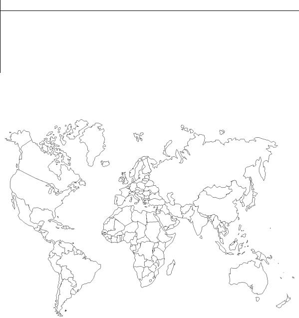
29. On the map (pic. 3) label the countries where the roads you |
||||
have read about are situated. |
|
|
|
|
|
|
б |
|
|
|
|
|
А |
||||
|
|
Д |
|||
|
|
Pic. 3 |
И |
||
|
|
|
|
|
|
30. Using the Internet, prepare a report on other roads. Be ready to answer the questions of your colleagues. You may tell about:
the Icknield Way, the Ridgeway, Boonsborough Turnpike Road, the Mullan Road, the Sweet Track и др.
20
31. Watch the video https://www.youtube.com/watch?v=brWkv1iV460, https://www.youtube.com/watch?v=YYgxwdu4Igc, https://www.youtube.com/watch?v=Ccxl9yigi90, read the texts and
summarize the information adding your own knowledge. |
|
С |
Appian Way |
|
|
Appian Way is a famous road of ancient Italy. The oldest and most |
|
celebrated highway of the Roman Republic, it was built in 312 BC by the Roman censor Appius Claudius Caecus. It led southward from the Servian Wall in Rome to Capua, passing through Appii Forum and Terracina, and
Greece,иthe Appian Way was more than 560 km (more than 350 mi) long. It was well constructed, although the present pavement of large hexagonal blocks, principallyбlava, laid on a firm foundation and strengthened by cement, is probably not the original bed. From Rome to Terracina the course is nearly straight, despite the steep grades of the Alban Hills and the swamps of the Pontine Marshes. Near Rome the road was lined with tombs, of which the ruinsАof many can still be seen. Parts of the road are still in use.
was later extended to Brundisium (now Brindisi). The main route to
The Appian Way was the first long road built specifically to transport troops outside the smaller region of greater Rome (this was essential to the Romans). The few roads outside Дthe early city were Etruscan and went mainly to Etruria. By the late Republic, the Romans had expanded over most of Italy and were masters of road construction. Their roads began at Rome, where the master itinerarium, or list of destinations along the roads, was located, and extended to the borders of their domain – hence the expression, “All roads lead to Rome”.
Silk Road is the most important premodernИtrade route linking China, Central Asia, Persia and western Asia, and Europe. A 19th-century German scholar named the network of trails the Silk Road for the precious Chinese cloth that was originally the most valuable and abundant commodity transported on it. Although historians traditionally date the origin of the Silk Road to the 2nd century BC, a trickle of goods – principally jades, bronzes, and silks – was conveyed across Central Asia as early as about 1000 BC.
Silk Road
21
Commerce persisted on the Silk Road until ocean-borne trade surpassed and superseded trade on the land route in the late 15th and early 16th centuries AD.
Although the economic significance of the Silk Road was limited, its cultural impact was great. As merchants, artisans, and missionaries traveled along the trade routes, they brought with them new products, ideas, technologies, and aesthetic principles. For example, in the late 2nd century AD, when the Han dynasty was declining and China was in chaos, the Chinese people found stability and comfort in a new religion introduced to them via Silk Road travelers. The religion, Buddhism, had originated in northern India in the 6th century BC. It began to appear in Central Asian
С |
st |
|
|
oases and towns, finally spreading into China in the 1 century AD. Bud- |
|
dhism greatly influenced not only the spiritual views of the Chinese but al- |
|
so their diets, funerary practices, knowledge of the outside world, and arts, |
|
as well as the economic structure of their society. The pagoda style in ar- |
|
chitecture,иnew designs and motifs in painting, and sculptures of the histor- |
|
ical Buddha and other Buddhist figures contributed enormously to Chinese |
|
art. Spectacular Buddhist sculptures and paintings were produced in the |
|
Mogao caves of Dunhuang and in Kyzyl (in present-day southeastern Rus- |
|
sia), two vitalбlocations along the Silk Road. |
|
Although the Silk Road no longer exists as a trade route, sites along its |
|
course remain important tourist destinations. These sites include the an- |
|
cient trading metropolises of Samarqand, Bukhara, and Khiva, and the |
|
towns of Dunhuang, Kashi, and Turpan, with their artistic and architectural |
|
treasures. |
А |
|
|
32. Scan the text (Ex. 33). Can you guess who and what these men |
|
are? (See pic. 4, 5) |
Д |
|
|
|
И |
Pic. 4 |
Pic. 5 |
22
33. Read, translate and give the title to the text.
In Europe, gradual technological improvements in the 17th and 18th centuries saw increased commercial travel, improved vehicles, and the breeding of better horses. These factors created an incessant demand for
Сbetter roads, and supply and invention both rose to meet that demand. In 1585 the Italian engineer Guido Toglietta wrote a thoughtful treatise on a pavement system using broken stone that represented a marked advance on the heavy Roman style. In 1607 Thomas Procter published the first Eng- lish-language book on roads. The first highway engineering school in Europe,иthe School of Bridges and Highways, was founded in Paris in 1747.
Up to this time roads had been built, with minor modifications, to the heavy Roman cross section, but in the last half of the 18th century the fathers of modern road building and road maintenance appeared in France and Britain.б
In France in 1764, Pierre-Marie-Jérôme Trésaguet, an engineer from an engineering family, became engineer of bridges and roads at Limoges and, in 1775, inspector general of roads and bridges for France. In that year he developed an entirelyАnew type of relatively light road surface, based on the theory that the underlying natural formation, rather than the pavement, should support the load. His standard cross section, 18 feet wide, consisted of an eight-inch-thick course of uniform foundation stones laid edgewise on the natural formation and coveredДby a two-inch layer of walnut-sized broken stone. This second layer was topped with a one-inch layer of smaller gravel or broken stone. In order to maintain surface levels, Trésaguet’s pavement was placed in an excavated trench – a technique that made drainage a difficult problem.
Thomas Telford, born of poor parents in Dumfriesshire,Иin Scotland, in 1757, was apprenticed to a stone mason; intelligent and ambitious, he progressed to designing bridges and building roads. Telford placed great emphasis on two features: (1) maintaining a level roadway with a maximum gradient of 1 in 30 and (2) building a stone surface capable of carrying the heaviest anticipated loads. His roadways were 18 feet wide and built in three courses: (1) a lower layer, seven inches thick, consisting of goodquality foundation stone carefully placed by hand (this was known as the Telford base), (2) a middle layer, also seven inches thick, consisting of broken stone of two-inch maximum size, and (3) a top layer of gravel or broken stone up to one inch thick.
23
The greatest advance came from John Loudon McAdam, born in 1756 at Ayr in Scotland. McAdam began his road-building career in 1787 but reached major heights after 1804, when he was appointed general surveyor for Bristol, then the most important port city in England. The roads leading to Bristol were in poor condition, and in 1816 McAdam took control of the
СBristol Turnpike. There he showed that traffic could be supported by a relatively thin layer of small, single-sized, angular pieces of broken stone
placed and compacted on a well-drained natural formation and covered by an impermeable surface of smaller stones. He had no use for the masonry constructions of his predecessors and contemporaries.
requiredиthe pavement to be elevated above the surrounding surface. The structural layer of broken stone was eight inches thick and used stone of two to three inches maximum size laid in layers and compacted by traffic – a process adequate for the traffic of the time. The top layer was two inches thick, using three-quarter- to one-inch stone to fill surface voids between the large stones. Continuing maintenance was essential.
Drainage was essential to the success of McAdam’s method, and he
Although McAdam drew on the successes and failures of others, his |
||
total structural reliance on broken stone represented the largest paradigm |
||
shift in the |
бhistory of road pavements. The principles of the “macadam” |
|
road are still used today. McAdam’s success was also due to his efficient |
||
administration and his strong view that road managers needed skill and |
||
motivation. |
А |
|
|
||
34. Listen to the words repeat them and try to memorize: |
||
demand – спрос |
|
|
invention – изобретение |
|
|
inspector general – ревизор |
|
|
road surface – поверхность дорогиД, дорожное покрытие |
||
support – поддерживать |
И |
|
cross section – поперечное сечение |
||
broken stone – щебень |
||
stone mason – каменщик |
||
condition – состояние compact – уплотнять void – пора, пустота
24

35. There are 27 words from the text. Find them and read out the sentences.
|
|
|
A |
B C D E F G H I J K L M N O P Q R S T |
||||||||||||||||||||
1 |
|
E |
I |
D |
M |
C |
R |
Q |
T |
E |
C |
H |
N |
O |
L |
O |
G |
I |
C |
A |
L |
|
||
2 |
|
N |
V |
F |
A |
O |
K |
O |
I |
N |
M |
Y |
V |
M |
C |
O |
L |
T |
C |
X |
K |
|
||
С |
A |
G |
I |
N |
D |
R |
A |
M |
L |
M |
L |
D |
T |
Y |
K |
A |
K |
N |
T |
|
||||
3 G |
|
|||||||||||||||||||||||
4 |
|
L |
Y |
A |
W |
T |
V |
I |
E |
D |
P |
V |
A |
E |
E |
H |
Z |
L |
D |
S |
H |
|
|
|
5 |
|
I |
L |
I |
D |
E |
I |
L |
F |
N |
- |
E |
H |
N |
A |
M |
F |
I |
Y |
B |
R |
|
|
|
6 |
|
S |
C |
M |
M |
M |
L |
C |
K |
I |
G |
B |
R |
I |
A |
D |
A |
A |
Z |
L |
E |
|
||
и |
I |
L |
O |
M |
C |
I |
U |
M |
G |
G |
I |
N |
W |
F |
E |
|
||||||||
7 H M F C P |
|
|||||||||||||||||||||||
8 |
|
- D E O O |
R |
N |
- |
N |
A |
A |
N |
I |
E |
H |
E |
N |
D |
I |
- |
|
|
|||||
9 |
|
L L P J R |
N |
O |
I |
D |
S |
I |
T |
E |
L |
A |
W |
R |
G |
I |
Q |
|
|
|||||
|
|
10 |
б |
|
|
|
|
|
|
|
|
|
|
|
|
|
||||||||
|
|
A |
A H B A M D V S |
R |
T |
N |
I |
E |
D |
B |
A |
S |
H |
U |
|
|
||||||||
11 |
|
N E T E R R A I E |
T |
A |
R |
T |
O |
R |
I |
L |
Y |
S |
A |
|
||||||||||
12 |
|
G W Q H I I P T T |
M |
R |
I |
U |
A |
N |
I |
N |
E |
Y |
R |
|
||||||||||
13 |
|
U G R O E G D U I |
I |
E |
A |
N |
C |
I |
S |
N |
G |
K |
T |
|
||||||||||
|
|
|
|
|
|
А |
E |
T |
N |
K |
G |
L |
E |
|
||||||||||
14 A X G P S O H G B O O N T |
|
|||||||||||||||||||||||
15 |
|
G B J R A O R T E L N N T |
I |
D |
I |
I |
F |
F |
R |
|
||||||||||||||
16 |
|
E Q T I C R N Y S S I Y Z |
S |
O |
X |
O |
N |
T |
N |
|
||||||||||||||
17 |
|
Q U M U T R E T P D S S M |
U |
Q |
N |
F |
N |
G |
E |
|
||||||||||||||
|
|
|
|
|
|
|
|
|
|
|
Д |
S |
K |
|
||||||||||
18 E I G H T - I N C H - T H I C K H J |
|
|||||||||||||||||||||||
19 |
|
U S Z P N X N K T C B I Z E X J K E |
G |
I |
|
|||||||||||||||||||
20 |
|
Q D U M F R I E S S H I R E D F E T |
J |
A |
|
|||||||||||||||||||
|
|
|
|
|
|
|
|
|
|
|
|
|
|
|
И |
|||||||||
36. Write the answers on a separate sheet of paper. Exchange your papers with the partner. Check the answers.
1. Where did the fathers of modern road building live? 2. What is the Telford base?
3. What are principles of “macadam” road?
4. What is a new type of road surface developed by Trésaguet?
25
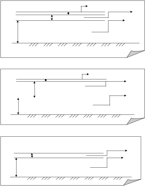
37. Which cross section of the road (A, B, C) was developed by Pierre-Marie-Jérôme Trésaguet, Thomas Telford and John Loudon McAdam? Label the road layers, showing the width of each layer.
С |
|
б |
|
и(A) |
|
А |
|
Д |
|
(B) |
И |
|
|
(C)
26
38.Tell about each pavement using the drawings.
39.You have to make a report on famous road builders. Use the information below for help.
СSaba (pronounced “SAY-ba”) is a small (13 sq. km) island in the Netherlands Antilles, located at latitude 63.13 degrees West, longitude 17.38 degrees North. It consists largely of the extinct volcano Mount Scenery (888 m), the highest point of the Kingdom of the Netherlands.
There are 1,300 inhabitants. Its major settlements include The Bottom and Windwardside. Despite the island’s Dutch affiliation, English is the principal language spoken on the island and is now used in its school
иChristopher Columbus is rumored to have sighted Saba on November 13, 1493, butбdid not land. The island was first colonized in 1640 by the Dutch.
system.
Through the 17th and 18th centuries its major industries were sugar and rum, and later fishing. In 1818 the Dutch took possession of Saba.
Saba Lace (alsoАknown as “Spanish work”) was a major export of Saba. In the 1870s, a young Mary Gertrude Hassell Johnson was sent to a Caracas convent for study – there she learned the craft. The lacework spread through the island. Ladies would copy addresses of businesses from shipping containers from the United States, and write to the employees. Often they would get orders for the lacework, and it started a considerable
There is one road, called simplyД“The Road”. Its construction was masterminded by Josephus Lambert Hassell who, despite the common opinion of Dutch and Swiss engineers, believedИthat a road could be built. He took a correspondence course in civil engineering, and started building the road with a crew of locals in 1938. After five years of work the first section of the road, from Fort Bay to The Bottom, was completed. It wasn’t
cottage industry.
however until 1947 that the first motor vehicle arrived. In 1951 the road to Windwardside and St. Johns was opened, and in 1958 the road was completed entirely.
Driving the road is considered to be a daunting occasion, and the curves in Windwardside are extremely difficult.
The island of Saba is known today for tourism and outstanding scuba diving. There are very few anchorages, and a small airport with service
27
from Saint Martin. There is also a ferry departing from Saint Martin.
Saba is known as the "Unspoiled Queen". Like the Dutch side of Saint Martin, the island is spotlessly clean.
40. Read the text and say about: СибАДИa) the first scientists who worked out the main principles of road
design;
b) the importance of motor-highways.
Automobile Transport
Transport communication of the national economy of our country is ensured by the system of several kinds of transportation: transportation by rail, water, air and motor transportation. Transport is entrusted with a very important task of the regular transporting of goods and people (passengers) in appointed time and with the least expenditure.
Each kind of transport fulfils this task according to the national economic plan, in the co-operation with other kinds of transport and according to its abilities and peculiarities. Motor-transport plays an extremely important role in the whole system of transport. But any effective use of motor-cars is impossible without modern motor-highways. This is why increasing the fleet of motor-vehicles and the growth of motor-transporting predetermines the improvement and growth of the network of motor highways.
In accordance with the growth of the importance of motor transport in the national economy the National Plan makes provision for the vast program of road construction. According to the Plan the network of improved motor-highways of Russia is to be increased and the existing net of highways is to be restored and capitally repaired.
Highway construction requires continuous preparation as to the investigation of roads, designing and research. The work of a number of the Russian associations of scientific workers and engineers ensured settling theoretical and practical questions as well as working out the bases of designing motor highways.
One of the leading and the first parts in this work belonged to professor Dubeleer (1874 – 1942).
Professor Dubeleer and his pupils worked out the main principles and methods of designing the draught and its elements as well as designing the subgrade, systematized all the existing materials and experience on de-
28
signing the roads. Soviet scientists settled many questions which are of great importance for the theory of the motor highways. These were the questions about the methods of designing and constructing the road surfaces (professor Ivanov N.N.), about the theoretical bases of road usage on the ground of interaction between the road and the motorcar (professor Birulya A.K.),about the principles of designing the subgrade (professor Dubeleer, professor Ornatsky, assistant professor Puzakov). As a result of work of the Soviet scientists and engineers who used home experience the designing of highways has become a vast branch of science.
41. Read and study the following words: |
|||
С |
|
|
|
ensure – обеспеч |
вать |
|
|
goods – товары |
|
|
|
expenditure – расходы |
|
||
fulfill – выполнять |
|
||
и |
|
||
fleet – парк (автомо илей) |
|
||
growth – рост |
|
|
|
vast – огромный |
|
|
|
belongб– принадлежать |
|||
branch – ветвь |
|
|
|
42. Make some sentences of your own with these expressions: |
|||
according to |
А |
||
|
|
Д |
|
in accordance with |
|||
as a result |
|
|
|
1.Transport is entrusted with a chief task ofИthe constant transporting of goods and people.
2.Each type of transport does this task.
3.But any effective use of motor-cars is impossible without up-to- date motor-highways.
4.In accordance with the growth of the importance of motortransport Plan makes provision for the huge program of road construction.
5.Professor Dubeleer and his pupils worked out the bases and meth-
ods of highway design.
29
44. Make up a written story or an oral report on one of the suggested topics.
1. Professor Dubeleer was the founder of the main principles of road Сdesign.
2. Professor Birulina A. K. and her work about the theoretical bases of road usage on the gradual of interaction between the road and the motorcar.
3. The importance of highway.
и45. What part of speech are the words in italics referred to?
1.The Russian transport is entrusted with very important tasks of the regular transporting of goods and people.
2.This is why increasing the fleet of motor-vehicles and the growth of motor-transporting predetermines the improvement and growth of the net-work of motor-highways.
3.The work of a number of scientists and engineers ensured settlingб
theoretical and practical questions.
4.One of the leading and the first parts in this work belonged to professor Dubeleer.
5.Professor Dubeleer and his pupils worked out the main principles and methods of designing the draught and its elements as well as designingА
the subgrade.
6.These are the questions about the road usage.
7.As a result of work of scientists and engineers who used home experience the designing of highways has become a vast branch of science.Д
46. Agree with the following statements using the appropriate |
|
passive form. |
И |
1.Each kind of transport fulfils this task.
2.The work of scientists influenced further development of highway
design.
3.Professor Dubleleer and his pupils worked out the main principles of highway design.
4.Scientists and engineers used home experience in their work and
theories.
30
ROAD. TYPES OF ROADS
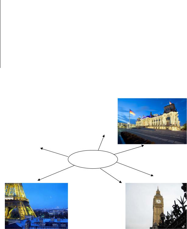
1. When you hear the word ROAD what do you think about? You have 3 minutes to find as many associations as possible.
С |
automobile? |
|
|
driver? |
|
road |
|
|
|
|
|
и |
|
|
2. Read the description of a road and add some ideas to your |
||
mind map. |
|
|
бRoad |
|
|
Road is a path established over land for the passage of vehicles, peo- |
||
ple, and animals. Roads provide dependable pathways for moving people |
||
А to concrete-paved multilane highways.Д
and goods from one place to another. They range in quality from dirt paths
Roads are used by various forms of transportation, such as trucks, automobiles, buses, motorcycles, and bicycles. Roads allow trucks to move goods from points of production, such as fields and factories, directly to markets and shopping centers. Private individuals rely on roads for safe and efficient automobile, motorcycle, and bicycle travel. Fire departments, medical services, and other government agencies depend on an organized system of roads to provide emergency services to the public in times of
need.
The earliest roads evolved from animal pathsИand served as trails for early hunters. Paths eventually grew around primitive settlements, and as trade grew, longer routes were developed to transport food and other important materials. The use of wheeled vehicles encouraged construction of better roads. The roads built by the ancient Romans were carefully planned and solidly constructed.
31
Modern methods of road construction were first developed in the 18th century. Innovations of the time included waterproof surfaces and better drainage systems. Modern engineers make use of a variety of materials and construction techniques to build roads that can handle the high volumes
and stresses of modern automobile and truck traffic. |
|
|
||||
С |
|
|
|
|
|
|
3. Find pairs of synonyms among the words below: |
|
|||||
road highway reliable |
goods |
system |
various factory |
|||
different |
dirt |
mud |
move |
truck |
lorry |
products |
plant |
travel |
network |
novelty primeval |
journey |
||
primitive |
transport |
innovation |
dependable |
|||
4. What do these words mean? |
|
|
|
|||
б |
|
|
|
|||
иquality safe emergency |
waterproof |
technique |
||||
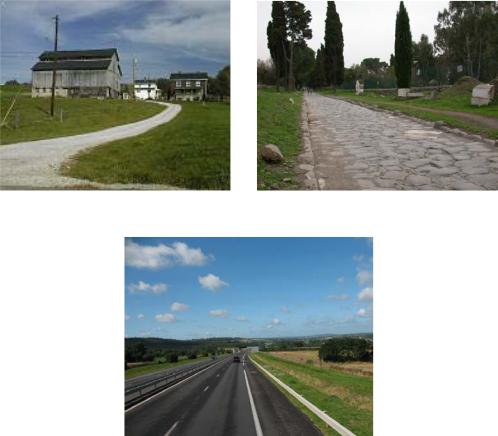
5. Look at the pictures (pic. 6–8) and compare the roads given: |
||||||
|
|
А |
|
|||
|
|
|
Д |
|||
|
Pic. 6 |
|
И |
|||
|
|
|
Pic. 7 |
|
||
Pic. 8
32
6. It is a well-known fact that there are various road classifications. For example, according to the passing conditions and road access all the roads are divided into 3 types. Work in 3 groups. Read
your text (group А – Highways, group В – Urban Streets, group С – Rural Roads), write out the key words/word combinations and describe your road type using the words.
СThere are many different types of highways. Highways differ primarily in the amount of access control they have and, therefore, in the amount of traffic they are designed to carry.
(А) Highways
Highways are high-speed roads designed to connect major cities.
иHighways with fully controlled access can handle the most traffic and are built to the highest construction standards. Interstate highways, freeways, and expresswaysбare examples of fully controlled-access highways. Vehicles that enter or exit these types of highways can do so only at certain points along the highway, generally by using special entrance and exit ramps. The ramps allow vehicles to access the road without disturbing the flow of traffic. IncomingАvehicles must merge with flowing traffic, and vehicles leaving the highway use exit ramps that guide them off the highway without blocking the traffic behind. Intersections with other roads are avoided by using either bridges known as overpasses to carry one roadway over another or short tunnel-like structures called underpasses to carry one roadway under another. Finished strips called shoulders on the edges of highways allow drivers of disabled vehicles to make repairs or await assistance without blocking traffic.
lanes for each direction of travel andДoften include medians (dividers in the middle of the road) to separate traffic moving in opposite directions. In Europe, highways with fully controlled access are called motorways, motorroutes, or autobahns.
Highways with fully controlled access generally have two or more И
Some highways offer only partial control of access. These types of highways handle less traffic than do highways with fully controlled access. Highways with partially controlled access may intersect other roads at the same level (called at-grade), rather than using overpasses or underpasses. Vehicles can enter highways with partially controlled access at intersections rather than using ramps. However, the right-of-way is often given to one direction of travel, rather than requiring all traffic to stop at the inter-
33
section. Giving the right-of-way to one direction of traffic helps keep traffic moving at higher speeds, although typically not at speeds as high as those on a highway with fully controlled access. One benefit of highways
with partially controlled access is that they are much cheaper to construct than highways with fully controlled access. Many U.S. and state highways are roads with partially controlled access.
Сhicles to access properties such as homes and businesses. Urban streets are usedиby private motor vehicles, public transportation, bicycle traffic, and pedestrians. Urban streets also accommodate underground public-utility facilities, such as electrical wiring, water and sewage pipes, and telecommunications lines. In addition, these streets must often be built around existing buildingsбand other barriers, such as parks and rivers. Rather than shoulders, urban streets usually have raised edges called curbs, which provide a barrier between the street and the adjoining property or sidewalk.
(В) Urban Streets
Urban streets, which cover cities, towns, and most suburbs, allow ve-
Urban streets are generally two-way paved roads that intersect each other frequently, allowingАa high degree of access but at slow speeds. Traffic lights and signs help regulate the movement of vehicles along these streets and control the access to some streets. Urban streets are usually classified as one of three types: local, collector, and arterial. These designations are based on the amount of Дtraffic each type is designed to carry.
Most urban streets are residential, or local, streets that allow vehicles to access public and private property. These streets make up 70 percent of total urban-road mileage but handle only 14 percent of all urban traffic. Collector streets convey traffic from residential streets to larger roads called arterials. Arterials are used to get quicklyИfrom one point to another and can accommodate high volumes of traffic. In large cities, arterials are often similar to highways in construction even though they are located within city limits. Although arterials account for only 17 percent of the ur- ban-road mileage, they account for most of the traffic in cities.
(С) Rural Roads
Rural roads are found in areas of the country outside cities, towns, and suburbs. Rural roads are also classified as local, collector, or arterial roads. Because of the light traffic and extensive mileage on these roads, design standards are relatively low. Rural roads may or may not have shoulders.
34
Local rural roads, which make up 69 percent of all rural roads, provide access to individual properties and farms. In many areas, local rural roads may be unpaved gravel roads. Two travel lanes, one for each direction of
travel, can accommodate normal traffic on local rural roads. Rural collector roads, which make up 23 percent of all rural roads, carry moderate traffic Сcoming in from a number of local roads. Collector roads have more and faster traffic than local roads and are constructed to a higher standard of
quality.
Rural arterial roads provide a high-speed network for heavier traffic between major towns in rural areas. They range from two-lane roadways to multiple-lane highways. These roadways are designed to carry more traffic than collector roads can and are usually constructed to even higher stand-
ards than rural collector roads are. Rural arterial roads often have finished |
|
shoulders and may have more than one lane in each direction. These roads |
|
make up 8 percent of total rural-road mileage. |
|
и |
|
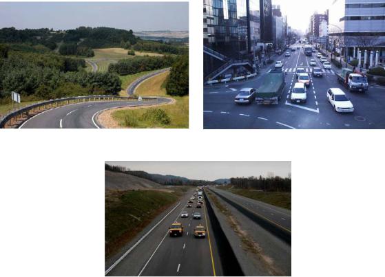
7. Look at the pictures (pic. 9–11) and identify the road type. |
|
Prove your answer. |
|
б |
|
|
А |
Pic. 9 |
ДPic. 10 |
|
И |
Pic. 11
35

8. Fill in the missed letters and express the main idea of the story in one sentence.
|
There are three basic cat_ _ _ _ _ _ _ of roadways: arterials, collec- |
|
tors, and local roads. This is the hie _ _ _ _ _ _ in how the roadway system |
||
С |
|
|
interacts with the land use system. Arterials function to m_ _ _ traffic. |
||
They have little – if any – access to land uses. The most prevalent example |
||
of an |
|
_ is I-84. Collectors are the connectors in the road_ _ _ |
system. They have ac_ _ _ _ to land uses, but also provide necessary movement. Some examples include Linder Road in Ada County and Locust Lane in Canyon County. Local roads give the greatest access to land uses and serve very localized pur_ _ _ _ _. The best example is the roadway in of a home in a subdivision.
|
9. There are special symbols (which look like formulae) used for |
|
roadиcharacteristics. Read the information and try to decode: |
||
|
A 5.4/6.2m k |
|
|
Bcgs 14/16 ft 1 (2.4km)(OB) |
|
|
А |
|
|
Road бclassification data is normally gathered in detail by the engi- |
|
neers. It is expressed as a formula. This standardized sequence consists of |
||
seven parts, as follows: |
|
|
|
(1) Prefix. The formula is prefixed by the letter "A" if there are no |
|
limiting characteristics. If there are limiting characteristics the letter "B" is |
||
used. |
(2) Limiting Characteristics. This is a series of specified small let- |
|
|
||
ters, each of which indicates a limiting characteristic. |
||
|
They are as follows: |
|
c |
Curves with a radius of less thanД25 meters. |
|
g |
Gradients of 7 percent or more. |
И |
d |
Inadequate drainage. |
|
f |
Unstable foundation. |
|
s |
Rough surface condition. |
|
jCamber is excessive.
An unknown or undetermined characteristic is indicated by a ques-
tion mark following the symbol to which it refers. For example, d? would indicate that there is some question about the adequacy of drainage.
36
|
|
(3) Width. |
|
|
|
||
|
|
The width of the traveled |
way |
is listed, followed by a slash and |
|||
the overall width of the road including the shoulders. For example, |
|||||||
14/16m would describe a road that has a traveled way of 14 meters and |
|||||||
an overall width of 16 meters. |
|
|
|||||
С |
|
|
|
||||
|
|
(4) Road Surface Material. |
|
||||
|
|
The road surface material is expressed by a small letter symbol as |
|||||
follows: |
|
|
|
|
|
||
k |
Concrete. |
|
|
|
|||
|
и |
|
|
||||
kb |
Bituminous/asphalt concrete. |
|
|||||
p |
Paving brick or stone. |
|
|
||||
rb |
Bitumen-penetrated macadam, water bound macadam with asphalt |
||||||
or tar covering. |
|
|
|
||||
r |
|
б |
|||||
Waterbound macadam, crushed rock or coral. |
|||||||
l |
|
Gravel or lightly metaled surface. |
|||||
nb |
Bituminous surface treatment on natural earth, stabilized soil, |
||||||
|
|
|
|
|
А |
||
sand-clay or other select material. |
|
||||||
b |
Used when the type of bituminous construction cannot be deter- |
||||||
mined. |
|
|
|
|
|
||
n |
Natural |
earth, |
stabilized |
soil, |
sand-clay, shell cinders, disintegrat- |
||
ed granite, or |
other |
select material. |
|
||||
v |
|
|
|
|
Д |
||
Various other type material not mentioned above. |
|||||||
|
|
(5) |
Length. |
|
|
|
|
|
|
The length of the road or portion to which the formula is being ap- |
|||||
plied may be listed next. It may be omitted. When it is shown, it is placed |
|||||||
in parentheses, e.g., (7.2 km). |
|
И |
|||||
|
|
||||||
|
|
(6) |
Obstruction. |
|
|
||
|
|
This entry in the formula is identical with the obstruction entry in the |
|||||
route classification formula. If there are any obstructions on the route, they are indicated in the formula by the symbol “OB”. Anything that restricts the type, amount, or speed of the traffic flow is considered an obstruction. The only exception is bridges.
(7) Special Conditions. Snow blockage and flooding are entered in the formula at this point, just as they are in the route classification formula. The symbols are the same, i.e., T for snow and W for possible flooding.
37
10.Work in pairs. Encode the information of a road and let your partner provide a description of your road.
11.Look at the chart and talk about each road type.
С |
|
Roads |
|
|
||
US |
State |
Indian |
National |
|||
Interstate |
|
|||||
Highways |
Highways |
Highways/ |
Roads |
Forest |
||
и |
County |
|
Service |
|||
Roads |
|
roads |
||||
12. Workбin 3 groups. Read and translate your text (one of the given below), then retell it to your group mates (you may write unknown words on the blackboard for your listeners’ better understanding). Then try to add some ideas to the previous exercise.
А Interstate Highways are the USДequivalent of Britain’s motorways,
(1) Interstate Highways
France’s autoroutes, Germany’s autobahns, Italy’s autostradas, etc. They are almost universally divided highways (dual carriageways) with a median (central reservation), controlled access via on and off ramps (slip roads) and at least two lanes plus a hard shoulder in each direction.
Interstate Highways are indicated on highwayИmarker shields, on signposts and on maps by a distinctive relatively simple shield containing the road number. Interstate Highways are usually specified as I-15, I-80, etc. (together with a compass direction if relevant, for example I-80 West or I-5 North).
With few exceptions, Interstate Highways retain the same road number across state boundaries, in many cases over huge distances and in some cases all the way from the Atlantic coast to the Pacific coast or from the
Canadian border to the Mexican border.
38
Long distance Interstate Highways are given one or two digit numbers. Interstate Highways through and round cities are given three digit numbers with the first digit even. Interstate spur roads into cities and loops around cities are given three digit numbers with the first digit odd. The last two digits of the number indicate the main Interstate to which the spur or loop
Сconnects, for example I-405 connects to I-5.
The suffix “Bus.”, “Business Loop” or “BL” indicates a road passing through a city. The suffix “Business Spur” or “BS” indicates a spur road running into a city.
In some states the exits on Interstates are given sequential numbers, whileиin others they are numbered within each state based on the mile
markers. In the latter case, if there are two exits in the same mile then each is given a letter suffix, for example Exit 35A and Exit 35B. California doesn’t number its Interstate exits and Alaska hasn't yet got any Interstate Highways.
US Highwaysбare important national trunk routes.
US Highways
The standard of АUS Highways varies considerably, from divided highway/controlled access roads (motorways/freeways) through four lane divided highways but without controlled access (dual carriageways) to tra-
ditional two lane roads. Even two lane highways tend to have wide hard shoulders but there are some exceptions, such as less important roads in mountainous regions.
US Highways are usually specifiedДas US50, US191, etc., together with a compass direction if relevant, for example US50 West or US50 East.
US Highways retain the same road number across state boundaries. Each US Highway number only applies to one highway throughout the en-
tire United States. И
(2) State Highways, State Roads, State Routes
State Highways vary from important trunk roads to quiet back roads. The standard of State Highways also varies very considerably. A very
small number of State Highways are divided highway/controlled access roads (motorways/freeways), notable examples being some of the freeways in Los Angeles. Some State Highways are four lane divided highways but
39
not controlled access (dual carriageways). However, the vast majority of State Highways are traditional two-lane highways.
State Highways are also often called State Roads or State Routes. All three terms are synonymous. Each State Highway number only occurs once within each state. However, the same number can and often does refer
Сto different State Highways in different states, which can occasionally be confusing.
State Highways are usually specified as SR5, etc (yet again with a compass direction if relevant), the SR meaning “State Road” or “State Route”. Another common method of referring to State Highways is by the officialиtwo letter abbreviation for the relevant state followed by the road number, for example Ca1 (meaning California State Highway 1) or Co89 (meaning Colorado State Highway 89). Sometimes the full name of the state is used, for example “California 49”. If the meaning is obvious, sometimes only theбinitial letter of the state is used, for example U143 or U-143 to refer to Utah State Highway 143.
The highway marker shields for State Highways are completely different in each US state. Each state uses a different design of shield for its State Highway markerАshield. The shields for State Highways are in most cases outlines of the state's shape on a map, a symbol associated with the state, or a simple geometrical shape. Details of the highway marker shield designs for each state can be found on this site in the “Introduction” page for each state, most easily accessedДvia the State/Province Index. As a general rule of thumb, if you see a highway marker shield which is not an Interstate, a US Highway or a pentagon shape, then it is almost certainly a State Highway.
Whereas Interstate Highways and US Highways are indicated on road maps in exactly the same way as they are on signpostsИand highway marker shields, a different system is used for State Highways. On road maps State Highways in all states are usually indicated by an outline circle, an ellipse or an oval, in each case containing the road number. However, in some cases State Highways may be indicated on maps by an outline rectangle containing the road number or by an outline simplified version of the State Highway marker shield containing the road number. Because different symbols can be used for State Highways, check the map’s legend.
In most cases State Highway road numbering is not consistent across state boundaries but in a small number of cases two states have agreed to
40
use the same road number, with a different state name prefix on each side of the boundary of course.
Almost all State Highways are paved but there are some exceptions. Maps always indicate unpaved roads.
(3) County Roads, Secondary Roads, Farm Roads, Ranch Roads, Indian |
|
С |
Roads, Forest Roads |
|
|
The names given to roads of lesser importance than county roads var-
ies from state to state. In most states these are called county roads or secondary roads. In Texas they are called farm roads and ranch roads. Arizona has Indian Routes and South Dakota has Bureau of Indian Affairs Highway System roads. There may also be additional names used in other states.
и are shown onбmaps then no road numbers may be indicated.
Since county roads are purely for local use in rural areas they are almost always traditional two-lane roads. They are not usually marked on national or state highway maps, only on highly detailed local maps. If they
Some county roads are paved, others are unpaved.
Many states use a pentagonal shaped shield for their county road marker shields. This has a blue background, yellow text and a yellow border. The pentagon is orientedАso that its base is horizontal. Some states and possibly some individual counties use other designs of shields. Some states use one or two letters to designate their county roads, with rectangular highway marker shields having white backgrounds and black text.
Routes and Forest Roads which applyДin all relevant states but the normal visitor is unlikely to encounter these.
If you know the designs of the shields used to indicate Interstates, US Highways and the State Highways in the state in question, then it is a reasonable assumption that any design of shield that you don't recognize al-
most certainly indicates a county road.
On road maps county roads are usually indicated, if at all, by an outline rectangle containing the road number or by an outline pentagon containing the road number. Because different symbols can be used for county roads, check the map's legend.
There are standard designs of highway marker shields for Indian И
The numbering system used for county roads varies from state to state. Some states use purely numbers, some states use letter prefixes followed
by numbers and some states use purely letters. In some states the same number (or combination of characters) is only used once within the state while in other states the same number (or combination of characters) is re-
41
peated – but never within the same county. The same county road number can and often does occur in numerous different states.
13. Now you have to work in pairs. Scan the information about |
||
US roads and streets and explain the difference between the following |
||
С |
|
|
notions: |
|
|
arterial highway |
collector road |
avenue |
parkway |
turnpike |
frontage road |
In the United States the paved roads carry the heaviest volume of traffic. They fall into four major categories: interstate highways (широкая ав-
тострада с 4 более полосами движения, соединяющая между собой несколько штатов), arterials (магистраль, примыкающая к скоростной автомаг ), collectors (основной проезд в микрорайоне), and lo-
cal roads and streets. The Interstate Highway System, used mainly for |
|
страли |
|
long-distance travel, comprises about 67,600 kilometers of the nation's |
|
road system. Although interstate highways make up only a little more than |
|
1 percent of all United States roads, they carry about 20 percent of the |
|
country’s traffic.бArterial highways are two-lane and four-lane roads that |
|
provide major routes connecting the interstate highways with towns and |
|
cities. Collector roads are urban and rural roads that connect cities and |
|
towns to the arterials and interstates. Local roads and streets serve farms, |
|
villages, and towns. |
А |
|
|
Although the terms road and highway are often used interchangeably, |
|
“highway” normally refers to a higher class of public road. Toll ways, or |
|
toll roads, are major roads that can only be entered and exited through toll- |
|
gates, where the driver pays a fee. Other kinds of roads include avenues |
|
and boulevards, which are broad cityДstreets that are usually bordered with |
|
trees; feeder roads (roads that feed traffic to a more major road); secondary |
|
rural highways (дорога низшей категории) (feeder roads connecting |
|
farms with towns and markets); primary highways,Иwhich are major, statemaintained roads; and expressways, high-speed, divided highways with partially or fully controlled access and grade separations at major intersections with other roads, advanced designs eliminating steep grades, sharp curves, and other hazards and inconveniences to driving. A freeway was originally a toll-free road with controlled access, but the term is now used interchangeably with “expressway” and includes toll roads. The term
42
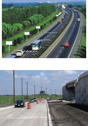
“parkway” refers to two types of road: on the one hand a toll road (usually of motorway standard), and on the other hand an outstanding scenic road from which trucks and heavy vehicles are excluded. “Turnpike” (скоростная платная автомагистраль) originally meant a toll road but now designates any expressway. A superhighway is a broad arterial highway de-
Сsigned for high-speed traffic; the term includes expressways, freeways, parkways, and turnpikes. A frontage road is a relatively minor road running alongside a main highway, for local traffic. There is often a frontage road on each side of a highway. In the country frontage roads provide access to farms, fields, etc., while in towns they provide access to motels, restaurants, shops, gas stations and other businesses. Frontage roads are normally two-way. It’s very important to remember that frontage roads and
roads in large car parks, such as at shopping malls, are still subject to the |
||
same rules and regulations as normal roads. For example, be sure to obey |
||
б |
|
|
stop signs on these roads. Frontage roads are also sometimes called service |
||
roads.и |
|
|
14. Look at the pictures (pic. 12–14). Can you define the road |
||
type? Explain. |
А |
|
|
|
|
|
Д |
|
|
Pic. 12 |
И |
|
|
|
Pic. 13
43
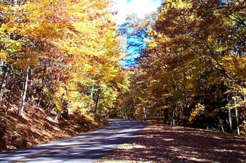
С |
|
|
Pic. 14 |
|
|
||||
|
|
|
|
|
|
||||
15. Find the odd word in a line. Why do you think so? |
|||||||||
replace |
|
add |
|
substitute |
change |
|
|||
иurban town citified |
rural |
|
|
||||||
comprise |
include |
constitute |
divide |
|
|||||
local |
|
district |
general |
restricted |
|
||||
community |
society |
union |
|
separation |
|
||||
access |
бadmission entrance departure |
|
|||||||
16. Change the letters of the given word to make a new one. |
|||||||||
Translate them. |
|
А |
|
||||||
orad - ? |
trips - ? |
anoint - ? |
|||||||
harps - ? |
Edgar - ? |
laud - ? |
|||||||
lean - ? |
Braun - ? |
tester - ? |
posh - ? |
sing - ? |
verse - ? |
||||
|
|
|
|
|
Д |
||||
es using the phrases.
17. Fill in the necessary preposition. MakeИup your own sentenc-
into on to by to on of to in
… most cases, a lot ..., to fall …, to refer …, to subject …, to be based …, to apply …, to be followed …, … the one hand
44
18. Match the word with its definition.
1) road, 2) highway, 3) motorway, 4) parkway, 5) street, 6) alley, 7) artery, 8) route, 9) way
a) … a way between places; esp. one with a prepared surface which Сvehicle can use.
b) … a wide road specially built for fast motor traffic, with a restricted number of places for entering and leaving. … have at least two separate lanes in each direction.
c) … a narrow passage for people to walk between or behind building or a path with a border of trees or hedges in a garden or park.
d) … a main road, usually connecting large towns.
e) … a wide road with trees, grass, etc. along the sides and/or the cen-
tral strip. |
б |
||
f) … a specified direction. |
|
||
иg) … an important route for traffic or transport. |
|||
h) … a public road in a city, town or village with houses and buildings |
|||
on one side or both sides. |
|
||
|
|
А |
|
i) … a way to go or send something from one place to another. |
|||
19. Draw pictures of the following roads (it is not necessary to be |
|||
an artist to do this task ): |
|
||
toll road |
|
boulevard |
|
parkway |
|
expressway |
|
|
|
|
И |
20. Do you know anything aboutДthe history of a parkway? When and where was it first built? How did it look like? Read the story and find the answers to the questions.
The parkway was introduced in its modern form in 1858 with the work of the landscape architects Frederick Law Olmsted and Calvert Vaux for Central Park in New York City. The concept was given further prominence by William Niles White of New York as a part of the Bronx River protection program of New York City and Westchester County. The 15mile, four-lane single carriageway known as the Bronx River Parkway was
45
built between 1916 and 1925. Protected on both sides by broad bands of parkland that limited access, the highway was located and designed so as to cause minimum disturbance to the landscape. Its use was restricted to passenger cars, and at-grade intersections were avoided. The success of the concept led to the creation of the Westchester County parkway system and
Сthe Long Island State Park Commission. More parkways were built in the New York area, including the Merritt Parkway (1934–40), which continued the Westchester Parkway System across Connecticut as a toll road providing divided roadways and limited access.
и21. Form 5 questions to the following text and let your groupmates answer them.
The freeway
The successбof the parkway system led to the introduction of the freeway, which is a divided highway with no conflicting traffic movements and no access from adjoining properties. In Germany between 1913 and 1921 a group called AVUS had built 10 kilometres of parkway through the Grunewald park in Berlin.АTheir successful experience led to the world's first full freeway being built from Cologne to Bonn between1929 and 1932. In 1933 Adolf Hitler began construction of an integrated freeway network known as the Reichsautobahnen, or “national motor roads,” beginning with the Frankfurt-DarmstadtД-Mannheim-Heidelberg Autobahn. One purpose of the program was to alleviate unemployment, but the roads also appealed to German nationalism and had a strong militaristic intent. The entire system included three north-south routes and three east-west routes. The highway provided separate 7.5-metre carriageways divided by a median strip of 5 metres. The roads were designedИfor large traffic volumes and speeds in excess of 150 kilometres per hour, bypassing cities and providing limited access. About 1,000 kilometres were completed by 1936, and 6,500 kilometres were in use when construction ceased in 1942.
The viability of the freeway concept in the United States was demonstrated by the Pennsylvania Turnpike. The Pennsylvania Turnpike Commission, established in 1937 to raise funds and build a toll road across the Appalachian Mountains, found an unusually favourable situation in the form of an abandoned railroad right-of-way, with many tunnels and excellent grades over much of the route that allowed the toll way to be completed in 1940 to freeway standards. The turnpike provided two 24-foot car-
46
riageways and a 10-foot median with no cross traffic at grade and with complete control of access and egress at 11 traffic interchanges. Its alignment and grades were designed for high volumes of high-speed traffic and its pavement to accommodate the heaviest trucks. The favourable public reaction to this new type of highway provided the impetus for the postWorld War II toll-road boom in the United States, advanced the start of a major interstate highway program, and influenced highway developments elsewhere. The Pennsylvania Turnpike, originally running from Harrisburg
|
to Pittsburgh, was later extended 100 miles east to Philadelphia and 67 |
||||||||||
|
miles west to the Ohio border, making it 327 miles long. An original fea- |
||||||||||
|
ture of the turnpike, later widely copied, was the provision of restaurant |
||||||||||
С |
|
|
|
|
|
|
|
|
|||
|
and fueling facilities. |
|
|
|
|
|
|
|
|
||
|
22. Fill in the table using the information about German and |
||||||||||
|
American freeways from the text above. |
|
|
|
|
|
|||||
|
и |
|
|
|
|
|
|
|
|||
|
Country |
|
Year of construction |
|
Length |
|
Purpose |
|
|
|
|
|
Germany |
|
|
|
|
|
|
|
|
|
|
|
|
|
|
|
|
|
|
|
|
|
|
|
USA |
|
б |
|
|
|
|
|
|
||
|
|
|
|
|
|
|
|
|
|||
|
23. Use the words to make word combinations. Make up your |
||||||||||
|
own sentences with them. |
|
|
|
|
|
|
|
|||
|
traffic |
road |
А |
|
way |
||||||
|
movement |
|
toll |
successful |
|
||||||
|
control |
feature |
experience |
|
motor |
complete |
original |
||||
24. |
Are there |
any freeways, parkways, expressways, frontage |
|||||||||
|
|
|
|
|
Д |
|
|
||||
|
roads in your city/town/region? If yes, can you show them on the map? |
||||||||||
|
|
|
|
|
|
|
И |
||||
How much does a bus ticket cost in your city? Do you pay for entering some of the roads? Have you ever entered toll roads? Read about tolls and charges in USA and Canada and answer the questions:
1. What does a toll based on?
2. What does ETC stand for?
3. What is E-ZPass?
4. What must you do if a toll road passes through a US National
Park?
47
Tolls and charges
Tolls, both for toll roads and toll bridges, tunnels, etc., tend to be very low in the USA and Canada. It isn't usually worth considering taking an alternative route just because of a toll. No sales tax is charged on road tolls, road bridge tolls or road tunnel tolls (or perhaps where relevant the tax is
included in the stated charge). СибАДИJames Cloninger of Columbus, Ohio describes the most commonly
used system for turnpikes (toll roads):
‘You get a ticket as you enter the turnpike, and your toll is based on the distance you travel. The ticket has a chart, indicating the toll based on your destination exit. Often the time when you enter and exit the tollway is marked on the ticket. That information is used to calculate your speed and issue a speeding ticket if you have been rather heavy-footed.’
The following information was kindly provided by Jeff Kitsko:
‘Electronic Toll Collection (ETC) is spreading across the US and Canada. E-ZPass is the electronic toll collecting system for most of the northeastern US, with other systems in various parts of the country. However, unlike the 407 ETR in Toronto, all US toll roads that use ETC also use tickets and cash. The writer from Columbus mentioned that the entry and exit time is calculated to determine if you were speeding and if so, you are issued a citation. I can assure you this is false.’
If a road passes through a US National Park then you must pay the park entrance fee at the entrance station, almost certainly located on the highway itself. Usually main roads which pass through National Monuments are free unless you intend to stop.
In Canada, in most cases motorists using a road through a National Park do not need to pay a toll unless they intend to stop. However, the Canadian authorities seem to be tightening up on this in recent years so I would highly advise anyone planning to stop to pay the park entrance fee. In Canada you often have to divert off the highway to visit the park's entrance station.
25. Read the following information and render it in English. Don’t forget to give the title, the source, the main idea, your attitude to the problem described.
48
Российские дороги станут безальтернативно платными
22 октября 2009 г.
Минэкономразвития выступило с предложением отказаться от обязательного наличия альтернативных бесплатных трасс при создании платных. Как заявил заместитель главы ведомства Андрей Клепач на ежегодной конференции UBS в Москве в среду, 21 октября, Минэкономразвития предлагает отказаться от предусмотренного законодательством обязательного наличия бесплатных дорог при строительстве платных маг стралей. «Мы предлагаем, чтобы механизм платно-
сти автодорог был более гибким, |
и не требовалось наличие альтерна- |
|||
С |
|
|
|
|
тивных бесплатных автодорог, таким образом можно будет ввести |
||||
большую часть маг стральных трасс как платные». |
||||
На эту |
дею |
М нэкономразвития подтолкнула необходимость |
||
привлечен я дополн тельных частных инвестиций в транспортную |
||||
|
. Заместитель ведомства отметил, что уже действую- |
|||
инфраструктуру |
|
|||
щие дороги тоже можно сделать платными. Как это часто бывает в |
||||
России при пр нят |
сомнительных решений, в пример приводится |
|||
зарубежный опыт. Похоже, так получится и в случае с платными ма- |
||||
гистралямиб. Клепач говорит, что во многих государствах отсутствуют |
||||
обязательные |
альтернативные |
есплатные дороги и отечественные |
||
автомобилисты « |
удут ездить так же, как ездят в Германии, Китае и |
|||
других странах», забывая при этом привести сопоставимые данные по |
||||
плотности автодорог в разных странах. |
||||
|
|
|
А |
|
На начало 2008 г. протяженность федеральных дорог состави- |
||||
ла 48,8 тыс. км, на них приходится более 40% все х грузо- и пас- |
||||
сажироперевозок. |
Тем не менее на эти значимые трассы прих о- |
|||
|
|
|
|
И |
дится менее 5% от общей протяженности российских дорог. В |
||||
2007 г. общая протяженность дорогДобщего пользования состави- |
||||
ла 746 тыс. км, |
при этом дорог с твердым покрытием – 623 |
|||
тыс. км. |
|
|
|
|
«Ничего кроме негатива у миллионов автомобилистов предложение не вызовет», – заявил корреспонденту GZT.RU Вячеслав Лысаков, лидер движения автомобилистов «Свобода выбора». Правозащитник называет предложение чиновников «абсолютной дикостью и политической провокацией». В России на фоне кризиса повышаются цены, создаются препятствия для потребителей, хотя в других странах все наоборот. Лысаков говорит, что у автовладельцев должна
49
быть свобода выбора, а предлагать строительство платных трасс без альтернатив в России, не обеспеченной дорожной сетью, – это безответственное заявление.
Если говорить о количестве платных дорог в европейских странах, исходя из их доли в общей дорожной сети, то на первом месте по
данным Всемирного банка (2007 г.) стоит Хорватия. При общей про- СибАДИтяженности дорог 24 тыс. км в стране платных 800 км или 3,33%. За ней следует Серб я. При аналогичной длине дорог протяженность
платных 650 км (2,71%). На третьем месте Швейцария, в которой плотность дорог выше – 71 тыс. км, но платных – 1,9 тыс. км (2,68 %).
Что касается друг х стран мира, то много платных магистралей в Аргент не: общая протяженность 216 тыс. км, а платных 9,8 тыс. км
(4,54%).
Асатур Бисембин
26. Study the chart (Table 1) and compare road tolls in various American states.
27. Find the information about shunpiking in the Internet and be ready to tell about it to your group.
28. Read the text below. How can you entitle it? Why?
The Romans had realized that a coordinated system of roadways connecting the major areas of their empire would be of prime significance for both commercial and military purposes. In the modern era, the nations of Europe first introduced the concept of highway systems. In France, for example, the State Department of Roads and Bridges was organized in 1716, and by the middle of the 18th century the country was covered by an extensive network of roads built and maintained primarily by the national government. In 1797 the road system was divided into three classes of descending importance: (1) roads leading from Paris to the frontiers, (2) roads leading from frontier to frontier but not passing through Paris, and
(3) roads connecting towns. By the early 1920s this general plan remained essentially the same except that a gradual change in class and responsibility had taken place. At that time the road system was divided into four classes: (1) national highways, improved and maintained by the national
50
government, (2) regional highways, improved and maintained by the department under a road service bureau appointed by the Department Commission, (3) main local roads, connecting smaller cities and villages, built
and maintained from funds of the communes supplemented by grants from |
||||||
the department, and (4) township roads, built and maintained by the com- |
||||||
С |
|
|
|
|
||
munities alone. |
|
|
|
|
||
29. Should any changes be made in the following schemes? Give |
||||||
your reasons. |
|
|
|
|
||
|
|
|
Road system |
|
|
|
|
|
|
(1797) |
|
|
|
|
|
|
|
|
|
|
|
|
|
|
|
|
|
|
б |
|
|
|||
|
|
|
||||
иParis - the frontiers frontier - frontier |
town - town |
|||||
|
|
|
А |
|||
|
|
|
national |
|
|
|
|
|
|
highways |
|
|
|
main local |
Д |
|||||
Road system |
regional |
|||||
|
|
roads |
(1920) |
highways |
||
|
|
|
township |
И |
||
|
|
|
|
|
||
roads
51

30. Look through the story. Supply the missing word parts to get the whole story. What is the main idea? What was new for you?
Street names in towns
Str_ _ _ _ in towns have na_ _ _ or street num_ _ _ _ which are inde- Сpendent of and additional to any highway numbering.
In many towns the str_ _ _ _ are n_ _ _ _ _ _ _: 12th Street, 15th Ave-
nue, etc. This especially applies in towns laid out in the block system.
At every inter_ _ _ _ _ _ _ of two str_ _ _ _ in towns throughout the USA and Canada there is a sign bea_ _ _ _ the names of the two str_ _ _ _
which cross. These signs normally consist of two small rectangular plates
bea |
the str |
names, mou_ _ _ _ at right angles to one another, |
||
with one sign under the other, on a pole near the inter_ _ _ _ _ _ _. On ma- |
||||
jorиroutes through towns the names of the str_ _ _ being crossed is some- |
||||
times indi_ |
on large overhead signs at each inter_ _ _ _ _ _ _. Often |
|||
the current block number is also indi |
, in smaller type, for example |
|||
“Colorado Ave 1200” (meaning that this inter |
_ _ _ is at the 1200 |
|||
|
б |
|
|
|
block of Colorado Avenue, i.e. buildings numbered 1200 to 1299). |
||||
Beware of str_ _ |
changing their names along their le_ _ _ _. In |
|||
small and medium sized towns this is very rare but in large cities where |
||||
what were once separateАsuburbs have now merged together it is not un- |
||||
common. |
|
|
|
|
Beware of str_ _ _ _ which are not continuous because of nat_ _ _ _ |
||||
features such as rivers, lakes and hills. You may need to divert onto other |
||||
|
|
Д |
||
str_ _ _ _ in order to reach a different section of a str |
. |
|||
31. Work in two groups. After reading Иthe text draw up a questionnaire for another group of students to find out how attentive these students are and how many facts they can remember.
UK road system
While the British recognized the necessity for national support of highways and a national system as early as 1878, it was the Ministry of
52

Transport Act of 1919 that first classified the roadway system into 23,230 miles of Class I roads and 14,737 miles of Class II roads. Fifty percent of the cost of Class I roads and 25 percent of the cost of Class II roads were to be borne by the national government. In the mid-1930s the need for a national through-traffic system was recognized, and the Trunk Roads Act of
С1939, followed by the Trunk Roads Act of 1944, created a system of roadways for through traffic. The Special Roads Act of 1949 authorized existing or new roads to be classified as “motorways” that could be reserved for special classes of traffic. The Highways Act of 1959 swept away all previous highway legislation in England and Wales and replaced it with a comprehensive set of new laws.
32. Watch the video
https://www.youtube.com/watch?v=yqmso0c9CBs as many times as |
|||
youиneed and write out ALL the terms with their definitions. Fill in the |
|||
table: |
|
|
|
|
|
А |
|
|
Term |
Definition |
|
|
б |
|
|
Road |
|
anything that connects two points |
|
Way |
|
|
|
|
|
|
|
|
|
|
|
|
|
Д |
|
|
|
И |
|
53