

Box 2.3. Case Study: Barbados's "Perfect Weather"
It hardly seems like one would need a reason to visit the Caribbean island nation of Barbados. That it has a reputation as a tropical island paradise is usually enough to create a distinct demand for the experience of such a destination. Yet, the island does not attract visitors from all over the world. Rather, there is a distinct geographic distribution of tourists to Barbados, as 79 percent come from only two geographic regions: North America and Europe. In particular, 34 percent come from just one country: the United Kingdom. Of course, there are many variables that we would need to consider if we were to fully understand these geographic patterns, such as historical relations, modern transportation connections between tourist- generating regions and the destination, levels of development in the generating regions, the type of attractions offered by the destination, and many more. However, one of the simplest explanations is weather.
Although there is relatively little seasonal variation for Barbados, there is nonetheless a distinct tourism season from November through April. In 2009, fully two-thirds of total tourist arrivals, including over three-fourths of cruise passenger arrivals, were concentrated in this six-month time period, consisting of the most difficult winter and early spring conditions for the majority of Barbados’s North American and Northern European tourists. In particular, December accounted for the largest number of arrivals, with nearly 14 percent of total arrivals. Conversely, the months that received the lowest visitor arrivals were the summer months, when these generating regions experience the most favorable weather conditions and when Barbados experiences its least favorable conditions. June saw the lowest arrivals by cruise ship, with only three percent of passengers. September, the peak of Atlantic hurricane season, saw the lowest arrivals by air, with only five percent of stay-over tourists.
Among Barbados’s many unique cultural and heritage attractions—and highly developed tourism amenities—one aspect of the destination that the Barbados Tourism Authority (BTA) emphasizes most is the island’s weather. In recognition of weather as a geographic push factor for their primary tourist market in Northern Hemisphere countries such as the United Kingdom, the United States, and Canada, the BTA has worked to ensure that these tourists are well aware that Barbados has the corresponding pull factor. Visit Barbados, the official website of the BTA, explicidy highlights the island’s “perfect weather.’’ On a designated page, the BTA claims, “With an average daily high temperature of 78°F/26°C, an average daily rainfall of less than V4 inch and 3000 hours of annual sunshine, it’s hard to imagine a place that enjoys weather any more perfect than in Barbados.”1 At the time of this writing—in February with overcast skies, a chance of wintery mixed precipitation, and a current local temperature of 28°F (in Texas, no less)—the page’s “perfect weather” weather report showed sunny skies and temperatures ranging from 82°F to 84°F for the following four days.
Discussion topic. What do you consider to be the greatest geographic push factor(s) for tourism from your home environment and why? What destination(s) do you think have the corresponding pull factor?
Tourism on the web: Barbados Tourism Authority, “Visit Barbados,” at http://www. visitbarbados.org/
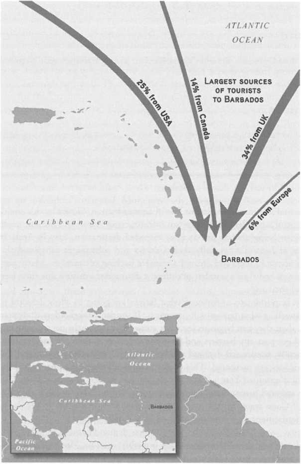
Map 2.1. Barbados, West Indies. The majority of tourists who visit this Caribbean island destination come from the significant generating regions in Europe and North America. (Source: XNR Productions)
(continued,)