

МІНІСТЕРСТВО НАУКИ І КУЛЬТУРИ, МОЛОДІ ТА СПОРТУ
УКРАЇНИ ВИ ІНИЦЬКИЙ БУДІВЕЛЬНІЙ ТКХНІКУМ
и.г. Кірссва
Practical Course of English
for Students of
Landmanager Faculty
Вінниця, 2012
МІНІСТЕРСТВО НАУКИ І КУЛЬТУРИ, МОЛОДІ ТА СПОРТУ
УКРАЇНИ ВИ ІНИЦЬКИЙ БУДІВЕЛЬНІЙ ТКХНІКУМ
МІНІСТЕРСТВО НАУКИ І КУЛЬТУРИ, МОЛОДІ ТА СІ ЮРТУ
УКРАЇНИ ВІННИЦЬКИЙ БУДІВЕЛЬНІЙ ТЕХІІІКУМ
И.Г. Кірееви
Practical Course of English for Students of
Landraanager Faculty
Розглянуто та затверджено цикловою комісією філологічних дисциплін
Протокол „N"1' _ ,£.________ __ від /& &..£./*-€'-&.*-/--?_____2012 року
І олова циклової комісії O.J. Рилссва Ofi?<-<-
- с
Вінниця, ВБТ, 2012
ПЕРЕДМОВА
Посібник призначений для студенті в-землевпорядників. Мета посібника -допомогти студентам навчитись самостійно читати і перекладати літературу зі спеціальності, викладати свої думки відповідно до запропонованих ситуацій, вести бесіду-діалог та обмінюватись практичною інформацією.
Посібник складається з передмови та 4 розділів: «Професія землевпорядника», «Геодезія та фотограметрія», «Сільськогосподарське виробництво», «Ґрунтознавство», тексти для сомостійного опрацювання студентами та англо-український словник.
Кожний розділ включає: лексику , автентичні тексти та лексичні вправи. Всі тексти оригінальні, взяті з сучасної англомовної технічної літератури, деякі з них частково адаптовані. Вони відображають найактуальніші науково-технічні проблеми фаху. У розділі «Геодезія та фотограмметрія» є стислий граматичний коментар, що охоплює найважливіші граматичні явища, характерні для фахово орієнтованих текстів із землевпорядкування: пасивний стан, неособові форми дієслова, багатокомпонентні означення, словотвір. Тексти та вправи для самостійного опрацювання сприятимуть засвоєнню студентами професійно орієнтованої лексики та орієнтують студента на здобуття інформації та самостійне використання мовного матеріалу в мовленнєвій діяльності.
Посібник вміщує також тексти для додаткового читання .
Добір текстів, розробку системи лексичних вправ та форм контролю виконано з урахуванням цільової установки чинної програми з іноземних мов.
Parti
Profession of a Landmanager
•
The additional information
• FIRST NAME: Yevhen
• SURNAME: Tkach
• DATE OF BIRTH: 11.11.1985
• NATIONALITY: Ukrainian
• LOCATION: Ukraine
• ready to move in Russia, Norway, EU countries.
• LANGUAGE: UA.RU.EN.
• EDUCATION: National University Lviv Polytechnic
• level 1 st - Bachelor (geodesy, mapping and land arrangement);
• level hi. - Specialist (engineer surveyor, photogrammetric.)
• YEARS: 1992-2003 school; 2004-2008 - Bachelor; 2008-2009 - Specialist.
• MOB.N.: [0935126316]
• PRIVATE E-MAIL: [evgen_tkach@mail.ru]
• CIVIL STATUS: not married
• PRESENT POSITION : engineer
• REASSIGNMENT DAYS : conditions with the employer
• YEARS OF EXPERIENCE: 16 months (official)
• KEY QUALIFICATIONS: stereo-pairs processing, DPS delta -2, DEM, fronts deformation, engineering surveys, maps and planning, pipeline design and systems, layout, control of formwork, control plans.
EXPERIENCE:
- Period: 1 year and more, from 15.08.2007 to 31.07.2008 served as technology.
- Employer: Oleksandyr Fok. Private enterprise «navgeoteh».
- Position: Lviv city. Bandery str. 61/16.
- Short description of work tasks/responsibility/project: Design of fiber-optic
lines.
- Definition of communication, causing them to maps.
- Country: Ukraine
- IT TOOLS: Digitals geodesy, TGoffice, AutoCAD, Photoshop, Mapinfow, Office.
NOW: Engineer surveyor on the stadium for Euro 2012. Lviv sity.
RESUME LANDMANAGER
RESUME
Engineer surveyor, photogrammetric
(geodesy, mapping and land arrangement)
From 25000 hryvnyas on a month, full
employment, distant work
Date of birth: on November,
11th 1985 (25 years)
Region: Lvov
It is ready to moving: Other countries
Aim
Architecture - researches of face-to-face plans, reflections of sculptures, difficult elements of frescos and other works for the purpose of modeling of high-precision drawings. Building - conducting process of erection, research вертикальностей, calculation, breakdown, a direction and other. Open-cast mine -quantity of extraction of the material, separate calculations. Volumes.
Kinds of shootings - electronic tachymeter, GPS navigators, Photogrammetrichesky researches at horizontal, vertical projections. Processing of stereopairs, land pictures and airfotopar. Modeling of digital plans and cards decoding, field decoding.
Experience Engineer surveyor With 05.2009 on 10.2010
company "Comfortbud-1" (capital construction and reconstruction) breakdown, brought out in nature, the volume of soil, executive drawings and diagrams.
Education The higher
With 09.2004 on 01.2009
National University Lviv Polytechnic, Geodesy Cartography and Land Management, city Lviv.
level 1 - Bachelor (geodesy, mapping and land arrangement); level 2 - Specialist (engineer surveyor, photogrammetric.)
Professional skills Skills of work with the computer:
- PC,
- reinstall under Windows,
- Office Equipment,
- Software: AutoCad, Digitals Delta, Photoshop, Office.

f
TASK 1. Read and translate the text using the vocabulary words:
to meet every requirement
curricula - pi. from curriculum
in accordance with
to correspond
to acquire
basic subjects
husbandry
to undertake
advanced courses
post-graduate course
відповідати усім вимогам
навчальні програми
відповідно до
відповідати
набувати
фундаментальні дисципліни
землеробство
здійснювати
курси підвищення кваліфікації
аспірантура
1. Ні. My name is Vlad Bortko. I am a student of Rivne National University of Water Management and Natural Resources Use. I'd like to tell some words about my faculty. I study at the Faculty of Ecology and Natural Resources Use that trains skilled specialists in agrochemistry. Founded in 1995, the faculty meets every requirement necessary for adequate training of up-to-date specialists: highly qualified teaching staff, well equipped scientific laboratories, computer classes, practical training complex and other facilities. The curricula are correlated in accordance with the newest scientific research and correspond to the latest world standards.
2. Future ecologists, agrochemists and specialists in water bio- resources study here. All of them acquire fundamental education in some basic subjects such as biology, physics, chemistry, geology, ecology, geodesy, methods of mathematical modelling, physics and chemistry of atmosphere and soil, and others. Future agrochemists must also have a clear view of some special and work-based courses such as cartography, phytopathology, basics of animal breeding, forestry, crop fertilizing, bio-technology, bio-organic chemistry, etc.
3. All these courses lead to diploma of higher school. You can get a degree of Bachelor, Specialist or Master. The specialist skills that you learn on your course are directly relevant to the job. Your training can be used as an entry to very many areas of activity, job locations and types of work-place, such as crop yielding, husbandry, horticulture, gardening, forestry, chemical industry, sciences and so on.
4. You will have a lot to learn about the particular area, and you may need to undertake further training both in the work-place and advanced courses, or at a post-graduate course at home or abroad.
TASK 2. Transform the sentences using the phrases:
according to: Your technical training can be used as an entry to very many areas of
activity, job locations and types of workplace.
therefore: The process industry depends on their specialists, which is why they recruit
technical people like you in the first place.
as well as: In the process industry, science and technology are exploited to yield saleable
products.
to look for: Your career, if you seek employment as a technical professional, will be
characterized by dealing with various problems
TASK 3. Choose relevant translation of the following words and phrases:
To meet every requirement, a degree, land resources, proper maintenance, valuable resource, scientific foundation, main branches, advanced courses, to depend on, basic subjects, the basis of
agriculture, a post-graduate course, the demand for specialists, work- based courses, areas of activity.
TASK 4. Make questions from the following jumbled words:
1. it, to become, was, an agrochemist, dream, your?
2. it, to study, boring, isn't?
3. can, in, be employed, spheres, our, what, graduates?
4. nowadays, is, enough, a degree, qualification?
5. you, bring...to, can, follow-up, what, education?
TASKS. Make dialogues using the above questions. Use phrases:
In my opinion... As far as I am able to judge... I consider that... 1 can't agree that...
TASK 6. Write down an annotation to the text using the key-words (Task 3).
TASK 7. Speak about your speciality using the plan and the key-words from Task 3.
1. Vinnytsia Building Technical School.
2. You faculty
3. Necessary knowledge.
4. Field of activity.
5. Follow-up education.
TASK 9. Present your professional ambitions, knowledge and skills to an employer. Don't forget to tell him where you studied
TASK 6. Read the following texts, annotate them and use the facts in the discussion.
TEXT 2
Some years ago a degree in one of professions was enough to put you in the top 5 per cent of the population. Today one in three young people enters higher education and a degree is fast becoming the minimum qualification. We now live in far more complex world and most jobs today require a much higher level of intellectual skills than ever before. Degrees are no longer enough - employers are looking for skills in the workplace. These key skills are communication, using and presenting numerical data, information technology, team-working, improving your own learning and performance, and problem solving.
Employers also look for some additional qualities such as adaptability and commercial awareness. Above all, they want graduates to have already had some practical experience of applying them. There is also increased interest in the ability to use other languages at work. And, of course, familiarity with the use of computers is a normal requirement for most jobs.
TEXT 3
Job titles vary widely from one employer to another. So you will need to look beyond them to find out what opportunities are available for you. Try to find out what is the "core" discipline for the organization. Finally, gather careers information: ask your colleagues at work, ask personnel officers, your supervisor, anyone who can help you get ideas about what jobs might become available, what they are like and how to go about getting one.
Considering your choice of future career you may as well take into account the following possibilities of placement.
Bacteriologist. Many bacteriologists specialize in identifying unknown microorganisms from the 2000 or so known types of bacteria. Others try to devise methods to combat harmful bacteria. Sill others study how disease-causing bacteria may be spread in our environment.
Laboratory technician. People who perform complicated microscopic tests in laboratories are called laboratory technicians. They work in veterinary hospitals and help in the detection of infectious diseases in pets and farm animals. Some may work in agriculture to help study the effects of microorganisms on farm crops. Other laboratory technicians work for water-treatment plants that use microorganisms to break down wastes into harmless substances. They help to make sure that the water that leaves the treatment plants is safe.
Plant breeder performs experiments that may change the size, the shape, or even the life span of plants. A plant breeder is a scientist who tries to improve plants through genetic methods. Plant breeders are employed by colleges and universities, government agencies, lumber and pharmaceutical industries, and seed and food companies-Science teachers spend much of their time developing lesson plans for different topics. They create interesting ways to present information to their students. Activities such as lectures, demonstrations, laboratory work and field trips are often used. They also attend meetings, conferences, and workshops.
LAND MANAGER
1. He prepares project proposals for land improvement; gathers and assembles supportive data describing the work to be done, present and proposed use, cost and benefit, local interest and work priority.
2. Gathers and analyzes much historical and legal information.
3. .Evaluates State owned lands to establish best and most profitable use and to initiate development actions and priorities.
4. Analyzes and determines leasing and marketing structures and environmental and legislative requirements.
5. Conducts land evaluation studies: completes surveys, locating property lines and site conditions.
6. Prepares maps and reports describing and analyzing observed conditions such as accessibility, terrain, vegetation, soils...
7. Coordinates with private operators, business operators and local governmental officials to identity developing land use needs; matches needs with potential offered by specific parcels of State owned land;
8. Appraises, evaluates and establishes land value and lease fee proposals .
9. Inspects lands under lease .
10. Investigates and initiates action on instances of apparent trespass.
11. Coordinates and supervises forestry work projects.
Vocabulary words
improvement |
поліпшення |
vegetation |
рослинність |
to assemble |
збирати |
soil |
земля, грунт |
benefit |
користь, |
condition |
умова |
|
прибуток |
official |
службовець, |
priority |
пріоритет |
|
посадовець |
legal |
юридичний |
parcel |
частина |
to evaluate |
оцінювати |
lease |
оренла |
to determine |
визначати |
fee |
оплата, гонорар |
requirements |
вимоги |
appraise |
оцінка |
to conduct |
вести |
to investigate |
досліджувати |
survey |
огляд |
instance |
приклад.зразок |
site |
місце |
apparent |
видимий |
accessibility |
доступність |
trespass |
володіння, |
terrain |
місцевість. |
|
порушення |
|
територія |
|
володіння |
|
|
to supervise |
наглядати |
DIALOGUE: THE FIRST MEETING WITH A LAND MANAGER.
- Haw do you do? ~ Haw do you do?
- What can I do for you, sir?
« 1 would like to order some work for me. Your firm was recommended by my old friend who use to deal with it some time ago.
- Oh, great! In some days I'll finish to fulfill the previous order and will ought to start with yours.
~ M.. But you are so young. I would prefer to speak to a more experienced land manager.
~ It's a pity my colleagues are out.
— How long have you been working here?
— Oh, two years ago I graduated from Vinnytsia Building Technical School. From that time I am working here. Now I am studying at Kyiv Engineering University on Land manager faculty on the last course. I am studying at the correspondence department.
— All right, all right. Good for you. Now I see you are a serious young girl.
— So, are you ready to deal with me?
— I have to think and to discuss that with my wife.
— Of course. I'll be looking forward for your decision.
DIALOGUE 2: THE SECOND MEETING WITH A LANDMANAGER.
— Mow do you do?
— How do you do?
— I've got some news for you. Our firm has already done some preparatory work for you.
— Oh, great!
— I've got a plan of your plot with all necessary measurement.
— Oh. really? 1 want to have a look at it. Mm... It's so little on paper!
— In fact, this lot is rather spacious to plant a pretty garden and to build a nice cottage with some sheds.
-- Maybe, maybe...
— It's position is very favourable. One side faces the quite street. It's not far from the bus stop. There's a pond in 500 meters from here - a nice place to rest in summer.
-- But a wasteland on the right...
— I think it's not a secret that you'll have neighbours who bought this plot last autumn. But I do not know their plans about it.
~ But how do you know?
~ Oh, they have a deal with our firm too.
— I hope they'll start to build a cottage soon and we'll not be the only family in this part of the street.
To cope efficiently with his work a land manager has to act strictly according to the plan.
PLAN OF ACTIONS OF A LAND MANAGER.
1. Survey the plot of land (closer definition of the plot's area).
2. Classification of the land.
3. Determination of boundaries of the plot.
4. Preparing of the state act for the possession of the plot.
The result of work of a land manager is a plan of the plot.
PLAN OF THE PLOT
1. The scale of the plan is 1:
2. The (measuring) survey was (fulfilled) carried out with a help of
3. Closer definition of the boundaries of the plot was fulfilled in the presence of adjoining land possessors. The protocol of agreement of boundaries was drawn.
4. Areas of outlines of the plot were calculated by co-ordinates with the help of computer.
MY SPECIALITY
(Land management and Cadastre, Gcoinformation Systems)
Geotechnical engineering is a broad field of specialisation. The major areas of work include site investigation, foundations engineering, rock and soil mechanics and acquisition of data to create analytical models to achieve solutions to clients' problems. Computers are used for design purposes and the creation of geotechnical data bases.
Initial desk studies consist of consultation of geological, topographical and soil maps and plans. Aerial photographs and satellite imagery may be required.
The land surveyor collects, manages and presents in computerised or graphic form accurate measurements of the earth's surface, its features, buildings and boundaries. This involves the use of optical and electronic instruments to carry out cadastral, topographical, photogrammatrical and engineering surveyors.
Engineering surveys are land surveyors who specialise in civil engineering construction. They undertake site surveys, setting out engineering drawings and locating the position of works.
Cartographers are compiling maps using computer assisted techniques.
Ukrainian State University trains bachelors, specialists and masters of sciences at the faculty of land management, cadastre and geoinformation systems. The term of studies lasts from 4 to 6 years. The course of studies includes general scientific, general technical and special subjects.
After the graduation from the University young specialists are able to work as site engineers, land surveyors, cartographers, landscape engineers, planning engineers, design engineers, junior and research workers, realtors, land managers, contract managers.
AT THE EXHIBITION.
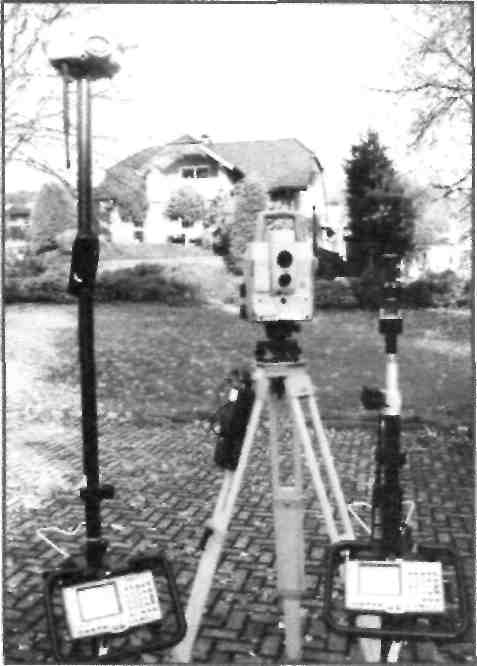
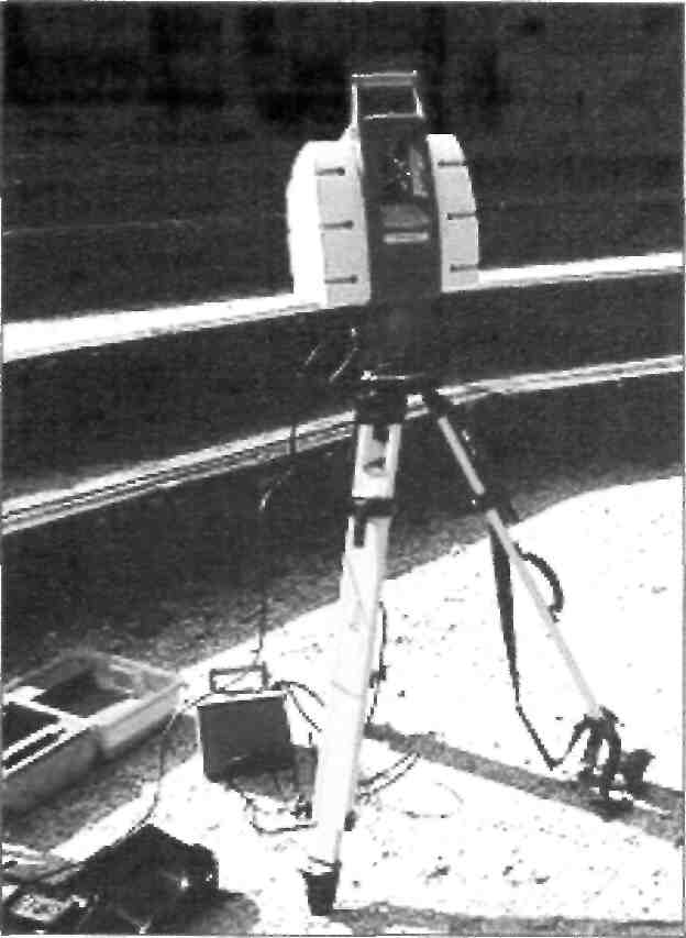
To know more about our future specialty we attend different exhibitions of professional equipment. Some time ago we visited one of them where some modern models of appliances for geodesic works were presented.
Students of our group studied all the exhibits with great interest. We asked questions which concern the usage and the exploitation of models of theodolite, GPS receiver, laser tape measure and level. Wc made some photos and took prospects. Then we made this stand with our commentaries.
And now other students will give you some useful information about some main sites of the exhibition.
LASER ROULETTE
The laser roulettes now are advanced technology of noncontact measurement of distances up to objects with any inclination to a surface. The roulettes have the built memory and integrated trigonometric functions, which give opportunities to define the sizes of windows on facades, structures and corners of an inclination of a roof.
For shooting the large rooms, facades of buildings and domes of churches the roulette can be put on theodolite.
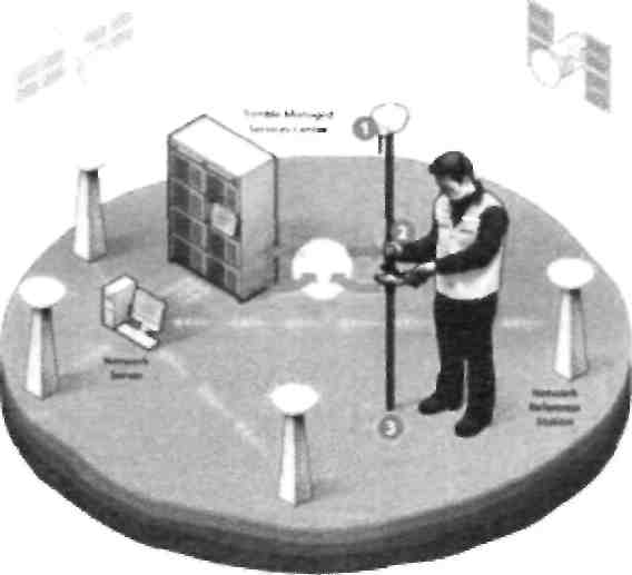
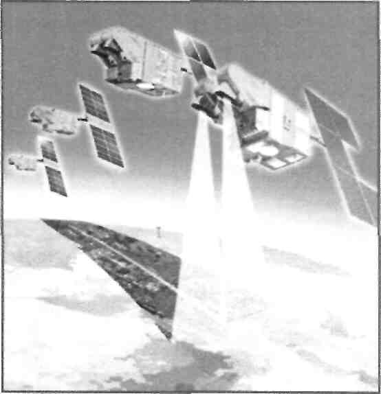
GPS RECEIVER
The GPS receiver is developed for the geodesists and topographers. The software represents spacious interface, which makes the receiver easy for study and use. The software gives all necessary means for management, display, processing of Ihc receiver. The high-sensitivity display enables to use the receiver at bad light exposure. The demountable accumulator gives a guarantee of work of the receiver long time in field conditions. The precision and reliable aerial enters into a complete set. It perfectly traces signals of the companions in hard conditions. The given devices allow to determine coordinates of basic items, the creations of a geodetic network are used for topographical shooting, the delimitations of the property etc. All models of GPS receivers are easy in use, strong and functional.
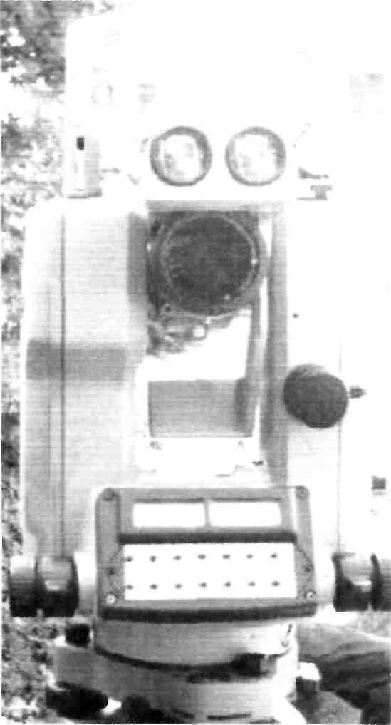
TACHEOMETER
The firm also presents the base series of newest electronic tacheometers. These devices are intended for the decision of wide spectrum of tasks in geodesy, building and cadastre.
New graphic display with warming up and comfortable keyboard that provide fast access to any menu item with possibility of introduction of both in letters and digital information. Presence of interface provides communication of tacheometer with a computer, thus for work can be used standard formats of data communication. All devices of the given series are equipped by the double-axis jack. Electronic tacheometer measuring of distances is provided without a reflector, and a visible red laser has the small corner of dispersion. It is used as a range-finder and folding device. In the standard mode of operations of tacheometer on measuring of length of line is expended less than one second, thanks to it any user can feel advantages of devise during work in difficult conditions even at presence of obstacles on the line of vise.
LEVEL
Firm "Leica Geosystems" offers the row of optical levels. High reliability and exactness of measuring are peculiarities of these devices. High fidelity optics eliminates any geometrical distortions of image. These levels are executed in a comfortable and modern design. They are simple and reliable in use. All models of electronic levels work on principles of digital processing of image for determining of height and distance with automatic registration of data. This appliances can be used:
— for topographical works;
— for geodesic and cadaster works;
— for landscape works, etc.
TEST
Match English and Ukrainian equivalents.
1. Geodesic appliances;
2. State act for the possession of the plot;
3. The scale of the plan;
4. Adjoining land possessors;
5. To determine the boundaries;
6. Laser tape measure;
7. GPS receiver;
8. Advantages of device;
9. Advanced technology;
10. High reliability and exactness;
11. The peculiarity of device; 12 .Legal information;
13. Cost and benefit;
14. To initiate development actions and priorities;
15. Local governmental officials;
16. To inspect lands under lease;
17. To conduct land evaluation; I8.T0 complete survey;
19. Land improvement:
20. Usage and exploitation.
1. GPS приймач;
2. Місцеві урядовці;
3. Ціна і прибуток;
4. Лазерна рулетка;
5. Передова технологія;
6. Визначити кордони;
7. Юридична інформація;
8. Ініціювати розвиток дій і пріоритетів;
9. Переваги пристрою;
10. Використання і експлуатація;
11. Висока надійність і точність;
12. Особливості пристрою;
13. Поліпшення земель;
14. Масштаб плану;
15. Суміжні землевласники;
16. Провести оцінку землі;
17. Інспектувати землі, надані в оренду;
18. Державний акт на власність земельної ділянки;
19. Геодезичне обладнання;
20. Закінчити огляд.
Part II
Geodesy and Photogrametry
GEODESY
Geodesy also named geodetics, a branch of earth sciences, is the scientific discipline that deals with the measurement and representation of the Earth, including
Earth 0
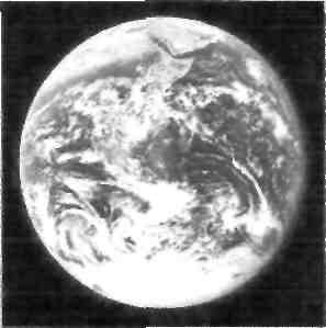
"The Blue Marble" photograph of Earth, taken from Apollo 17
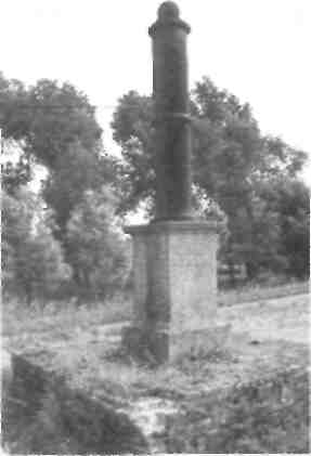
An old geodetic pillar (1855) at
Ostend, Belgium
its gravitational field, in a three-dimensional
time-varying space.
Geodesists also study
geodynamical phenomena such as crustal motion, tides, and polar motion. For this they design global and national control
networks, using space
and terrestrial techniques while relying on datums and
coordinate systems.
DEFINTION
Geodesy (from Greek - geodaisia, lit. "division of the Earth") is primarily concerned with positioning within the temporally varying gravity field. Somewhat obsolete nowadays, geodesy in the German speaking world is divided into "Higher Geodesy"
("Erdmessung" or "hohere
Geodasie"), which is concerned with measuring the Earth on the global scale, and "Practical Geodesy" or "Engineering Geodesy"
("Ingenieurgeodasie"), which is concerned with measuring specific parts or regions of the Earth, and which includes surveying.
The shape of the Earth is to a large extent the result of its rotation, which causes its equatorial bulge, and the competition of geological processes such as the collision of plates and of volcanism, resisted by the Earth's gravity field. This applies to the solid surface, the liquid surface (dynamic sea surface topography) and the Earth's atmosphere. For this reason, the study of the Earth's gravity field is called physical geodesy by some.
1. Surveying
2. Accurately
3. Determining
4. Three-dimensional
5. Angle
6. To establish
7. Ownership
8. Observation
9. Measurements
10. Subdivision 11 .To involve
12. Judicial
13. Accumulation
14. layout
15. Volume 16.Essential 17.Execution 18. Familiar 19.To exist 20.To record 21. Ancient 22.Bank
23. Rope
24.To stretch
25. Perfect
26.North-south orientation
2 7. Be fore Christ
28.Land register
29. Peg
30.Millennium
31.Tax
32.To conquer
33.To invent
34.Level
35. Triangular
Зб.СігсІе
37. Rotating
38.To research
39.Legal instruments
40.Data analysis
Geodesy
геодезія
точний визначення тривимірний кут
встановити, визначити власність
спостереження, огляд вимірювання підрозділ включати
судовий, юридичний накопичення проект об" см важливий здійснення відомий існувати записувати стародавній берег річки мотузка тягнути досконалий
північно-південний напрямок до Різдва Христа земельний регістр кілок
тисячоліття податок завойовувати винаходити рівень трикутник коло
ротація, обертання досліджувати юридичні документи аналіз даних.
GEODESY
Surveying or land surveying is the technique and science of accurately determining the terrestrial or three-dimensional position of points and the distances and angles between them. These points are usually on the surface of the Earth, and they are often used to establish land maps and boundaries for ownership or governmental purposes.
Furthermore, a particular type of surveying known as "land surveying" is the detailed study or inspection, as by gathering information through observations, measurements in the field, questionnaires, or research of legal instruments, and data analysis in the support of planning, designing, and establishing of property boundaries. It involves the re-establishment of cadastral surveys and land boundaries based on documents of record and historical evidence, as well as certifying surveys (as required by statute or local ordinance) of subdivision plats/maps, registered land surveys, judicial surveys, and space delineation. Land surveying can include associated services such as mapping and related data accumulation, construction layout surveys, precision measurements of length, angle, elevation, area, and volume, as well as horizontal and vertical control surveys, and the analysis and utilization of land survey data.
Surveying has been an essential element in the development of the human environment since the beginning of recorded history (about 5,000 years ago). It is required in the planning and execution of nearly every form of construction. Its most familiar modern uses are in the fields of transport, building and construction, communications, mapping, and the definition of legal boundaries for land ownership.
History of surveying
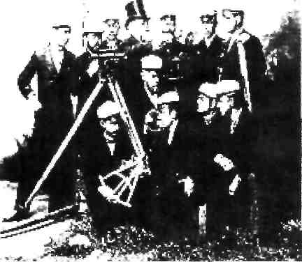
Surveying students with professor at the Helsinki University of Technology in the early 20th century.
Surveying techniques have existed throughout much of recorded history. In ancient Egypt, when the Nile River overflowed its banks and washed out farm boundaries, boundaries were re-established by a rope stretcher, or surveyor, through the application of simple geometry. The nearly perfect squareness and north-south orientation of the Great Pyramid of Giza, built c. 2700 BC, affirm the Egyptians' command of surveying.
•The Egyptian land register (3000 BC).
•A recent reassessment of Stonehenge (c. 2500 BC) indicates that the monument was set out by prehistoric surveyors using peg and rope geometry. '
•The Groma surveying instrument originated in Mesopotamia (early 1st millennium BC).l2J
•Under the Romans, land surveyors were established as a profession, and they established the basic measurements under which the Roman Empire was divided, such as a tax register of conquered lands (300 AD).
•The rise of the Caliphate led to extensive surveying throughout the Arab Empire. Arabic surveyors invented a variety of specialized instruments for surveying, including:131
о Instruments for accurate leveling: A wooden board with a plumb line
and two hooks, an equilateral triangle with a plumb line and two hooks, and a reed level.
о A rotating alhidade, used for accurate alignment.
о A surveying astrolabe, used for alignment, measuring angles,
triangulation, finding the width of a river, and the distance between two points separated by an impassable obstruction.
•In England, The Domesday Book by William the Conqueror (1086)
о covered all England
о contained names of the land owners, area, land quality, and specific
information of the area's content and inhabitants.
о did not include maps showing exact locations
In the 18th century in Europe triangulation was used to build a hierarchy of networks to allow point positioning within a country. Highest in the hierarchy were triangulation networks. These were densified into networks of traverses (polygons), into which local mapping surveying measurements, usually with measuring tape, corner prism and the familiar red and white poles, are tied. For example, in the late 1780s, a team from the Ordnance Survey of Great Britain, originally under General William Roy began the Principal Triangulation of Britain using the specially built Ramsden theodolite. Large scale surveys are known as geodetic surveys.
•Continental Europe's Cadastre was created in 1808
о founded by Napoleon I (Bonaparte)
о contained numbers of the parcels of land (or just land), land usage,
names etc., and value of the land
о spread fast around Europe, but faced problems especially in
Mediterranean countries, Balkan, and Eastern Europe due to cadastre upkeep costs and troubles.
A cadastre loses its value if register and maps are not constantly updated. Because of the fundamental value of land and real estate to the local and global economy, land surveying was one of the first professions to require Professional
Licensure. In many jurisdictions, the land surveyors license was the first Professional Licensure issued by the state, province, or federal government.
Historically, distances were measured using a variety of means, such as with chains having links of a known length, for instance a Gunter's chain, or measuring tapes made of steel or invar
Historically, horizontal angles were measured using a compass, which would provide a magnetic bearing, from which deflections could be measured. This type of instrument was later improved, with more carefully scribed discs providing better angular resolution, as well as through mounting telescopes with reticles for more-precise sighting atop the disc (see theodolite). Additionally, levels and calibrated circles allowing measurement of vertical angles were added, along with verniers for measurement to a fraction of a degree—such as with a turn-of-the-century transit.
The simplest method for measuring height is with an altimeter— basically a barometer — using air pressure as an indication of heightTriangulation is another method of horizontal location made almost obsolete by GPS. With the triangulation method, distances, elevations and directions between objects at great distance from one another can be determined. Since the early days of surveying, this was the primary method of determining accurate positions of objects for topographic maps of large areas. A surveyor first needs to know the horizontal distance between two of the objects. Then the height, distances and angular position of other objects can be derived, as long as they are visible from one of the original objects. High-accuracy transits or theodolites were used for this work, and angles between objects were measured repeatedly for increased accuracy.
Building surveying
Building surveying emerged in the 1970s as a profession in the United Kingdom by a group of technically minded General Practice Surveyors.[6] Building surveying is a recognised profession in Britain, Australia and Hong Kong. In Australia in particular, due to risk mitigation and limitation factors, the employment
of surveyors at all levels of the construction industry is widespread. There are still many countries where it is not widely recognized as a profession.
Services that building surveyors undertake are broad but can include:
* Construction design and building works
* Project management and monitoring
* Property Legislation advice
* Insurance assessment and claims assistance
* Defect investigation and maintenance advice
* Building surveys and measured surveys
* Handling planning applications
* Building inspection to ensure compliance with building regulations
* Pre-acquisition surveys
* Negotiating dilapidations claims.
Building surveyors also advise on many aspects of construction including:
* design
* maintenance
* repair
* refurbishment
* restoration and preservation of buildings and monuments.
Clients of a building surveyor can be the government agencies, businesses and individuals. Surveyors work closelv with architects, planners, homeowners and tenants groups. Building surveyors may also be called to act as an expert witnesses. It is usual for building surveyors to earn a college degree before undertaking structured training to become a member of a professional organisation.
With the enlargement of the European community, the profession of the building surveyor is becoming more widely known in other European states, particularly France, where many English-speaking people buy second homes.
Lidar Surveying - Three-dimensional laser scanning provides high definition surveying for architectural, as-built, and engineering surveys. Recent technological
advances make it the most cost-effective and time-sensitive solution for providing the highest level of detail available for interior and exterior building work.
Modern Surveying Instruments
In conventional surveying, chain and tape are used for making linear measurements while compass and ordinary theodolites are used for making angular measurements. Levelling work is carried out using a Dumpy level and a levelling staff. With such surveying instruments, survey work will be slow and tedious.
Hence modern surveying instruments are becoming more popular and they are gradually replacing old surveying instruments such as compass and Dumpy level. With modem surveying instruments, survey work will be precise, faster and less tedious. Some of the modern surveying instruments are discussed in brief, in the following pages.
1. Electronic Distance Measurement (EDM) Instruments
Direct measurement of distances and their directions can be obtained by using electronic instruments that rely on propagation, reflection and reception of either light waves or radio waves. They may be broadly classified in to three types:
a. Infrared wave instruments.
b. Light wave instruments.
c. Micro wave instruments, a. Infrared wave instruments
These instruments measure distances by using amplitude modulated infrared waves. At the end of the line, prisms mounted on target are used to reflect the waves. These instruments are light and economical and can be mounted on theodolites for angular measurements. The range of such an instrument will be 3 km and the accuracy achieved is ± 10 mm.
DISTOMATDI 1000
It is a very small, compact EDM, particularly useful in building construction and other Civil Engineering works, where distance measurements are less than 500 m. It is an EDM that makes the meaning tape redundant. To measure the distance,
one has to simply point the instrument to the reflector, touch a key and read the result.
b. Light wave instruments
These are the instruments which measures distances based on propagation of modulated light waves. The accuracy of such an instrument varies from 0.5 to 5 mm / km distance and has a range of nearly 3 km.
Eg: Geodimeter
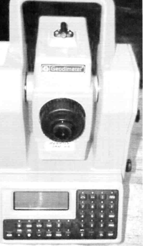
This instrument which works based on the propagation of modulated light waves, was developed by E. Bergestand of the Swedish Geographical Survey in collaboration with the manufacturer M/s AGA of Swedish. The instrument is more suitable for night time observations and requires a prism system at the end of the line
for reflecting the waves.
Geocentric coordinate systems used in geodesy can be divided naturally into two classes:
1. Inertial reference systems, where the coordinate axes retain their orientation relative to the fixed stars, or equivalently, to the rotation axes of ideal gyroscopes; the X axis points to the vernal equinox
2. Co-rotating, also ECEF ("Earth Centred, Earth Fixed"), where the axes are attached to the solid body of the Earth. The X axis lies within the Greenwich observatory's meridian plane.
The prime meridian at Greenwich, England
The coordinate transformation between these two systems is described to good approximation by (apparent) sidereal time, which takes into account variations in the Earth's axial rotation (length-of-day variations). A more accurate description also takes polar motion into account, a phenomenon closely monitored by geodesists.
CfcLfcSriAL EQUATOR
Orbit direction
NORTH CELESTIAL
POLE
Perpendicular
to orbit r
I Axial tilt 7^—J
I "
_ Obliquity
I
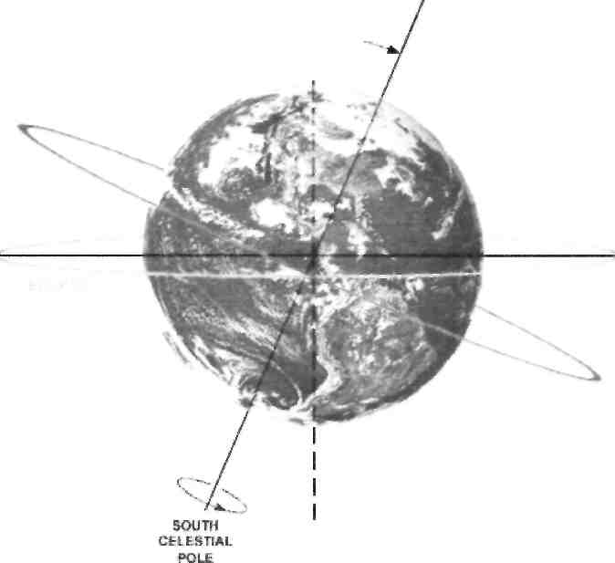
Rotation Axis
COORDINATE SYSTEMS IN SPACE
Geodetic system
>4
<—t-
(2,3)
Illustration of a Cartesian coordinate plane. Four points are marked and labeled with their coordinates: (2,3) in green, (-3.1) in red, (-1.5.-2.5) in blue, and the origin (0,0) in purple.
The locations of points in three-dimensional space are most conveniently described by three cartesian or rectangular coordinates, X,Y and Z. Since the advent of satellite positioning, such coordinate systems are typically geocentric: the Z axis is aligned with the Earth's (conventional or instantaneous) rotation axis.
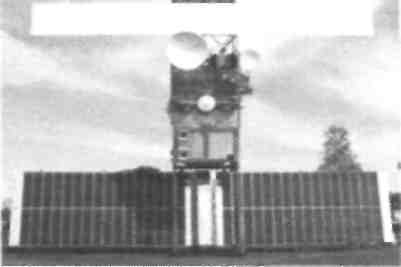
A full size model of the Eartn observation satellite ERS 2
Illustration of Anaximander's models of the universe. On the left, daytime in summer; on the right, nighttime in winter
Prior to satellite geodesy era, the coordinate systems associated with a geodetic datum attempted to be geocentric, but their origins differed from the geocentre by hundreds of metres, due to regional deviations in the direction of the plumbline (vertical). These regional geodetic datums, such as ED50 (European Datum 1950) or NAD83 (North American Datum 1983) have ellipsoids associated with them that are regional 'best fits' to the geoids within their
areas of validity, minimising the deflections of the vertical over these areas.
It is only because GPS satellites orbit about the geocentre. that this point becomes naturally the origin of a coordinate system defined by satellite geodetic means, as the satellite positions in space are themselves computed in such a system.
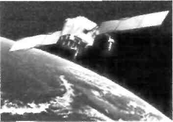
Artist's conception of GPS Block ll-F satellite in orbit
PHOTOGRAMMETRY
Photogrammetry is the practice of
determining the geometric properties of objects
from photographic images. Photogrammetry is as
old as modern photography and can be dated to
the mid-nineteenth century.
In the simplest example, the distance
between two points that lie on a plane parallel to
the photographic image plane can be determined
by measuring their distance on the image, if the
scale s of the image is known. This is done by
multiplying the measured distance by 1 /s.
A more sophisticated technique, called
stereophotogrammetry, involves estimating the
three-dimensional coordinates of points on an
object. These are determined by measurements
made in two or more photographic images taken from different positions (see
stereoscopy). Common points are identified on each image. Л line of sight (or ray)
can be constructed from the camera location to the point on the object. It is the
intersection of these rays (triangulation) that determines the three-dimensional
location of the point. More sophisticated algorithms can exploit other information
about the scene that is known a priori, for example symmetries, in some cases
allowing reconstructions of 3D coordinates from only one camera position.
Photogrammetry is used in different fields, such as topographic mapping, architecture, engineering, manufacturing, quality control, police investigation, and geology, as well as by archaeologists to quickly produce plans of large or complex sites and by meteorologists as a way to determine the actual wind speed of a tornado where objective weather data cannot be obtained. It is also used to combine live action with computer-generated imagery in movie post-production; Fight Club is a good example of the use of photogrammetry in film (details are given in the DVD extras).
POIN POSITIONING
Point positioning is the determination of the coordinates of a point on land, at sea, or in space with respect to a coordinate system. Point position is solved by computation from measurements linking the known positions of terrestrial or extraterrestrial points with the unknown terrestrial position. This may involve transformations between or among astronomical and terrestrial coordinate systems.
The known points used for point positioning can be triangulation points of a higher order network, or GPS satellites.
Traditionally, a hierarchy of networks has been built to allow point positioning within a country. Highest in the hierarchy were triangulation networks. These were densifled into networks of traverses (polygons), into which local mapping surveying measurements, usually with measuring tape, corner prism and the familiar red and white poles, are tied.
Nowadays all but special measurements (e.g., underground or high precision engineering measurements) are performed with GPS. The higher order networks are measured with static GPS, using differential measurement to determine vectors between terrestrial points. These vectors are then adjusted in traditional network Fashion. Л global polyhedron of permanently operating GPS stations under the auspices of the IERS is used to define a single global, geocentric reference frame which serves as the "zero order" global reference to which national measurements are attached.
For surveying mappings, frequently Real Time Kinematic GPS is employed, tying in the unknown points with known terrestrial points close by in real time.
One purpose of point positioning is the provision of known points for mapping
measurements, also known as (horizontal and vertical) control. In every country, thousands of such known points exist and are normally documented by the national mapping agencies. Surveyors
involved in real estate and insurance will use these to tie their local
measurements to.

Algorithms for photogrammetry typically express the problem as that of minimizing the sum of the squares of a set of errors. This minimization is known as bundle adjustment and is often performed using the Levenberg-Marquardt algorithm.
|
n eitenor orientations |
V-v |
image co-oidinates from views.-: |
|
|
|
\ |
Photogrammetry ч |
|
additional |
|
|||
observations |
|
/Av^A |
||
|
|
it |
||
|
camera model]is) |
3-Dco-oidmates |
||
|
^ |
--------------- --------------------j |
||
Photogrammetric methods
Cri'-U1.1.
WtMIr
TRlMMLr- \ІЩ% HGW-
Photogrammetry uses methods from many disciplines, including optics and projective geometry. The data model on the right shows what type of information can go into and come out of photogrammetric methods.
The 3D co-ordinates define the locations of object points in the 3D space. The image coordinates define the locations of the object points' images on the film or an electronic imaging device. The exterior orientation of a camera defines its location in space and its view direction. The inner orientation defines the geometric parameters of the imaging process. This is primarily the focal length of the lens, but can also include the description of lens distortions. Further additional observations play an important
role: With scale bars, basically a known distance of two points in space, or known fix points, the connection to the basic measuring units is created.
Each of the four main variables can be an input or an output of a photogrammetric method.
Photogrammetry has been defined by the American Society for Photogrammetry and Remote Sensing (ASPRS) as the art, science, and technology of obtaining reliable information about physical objects and the environment through processes of recording, measuring and interpreting photographic images and patterns of recorded radiant electromagnetic energy and other phenomena.
Integration
Photogrammetric data with dense range data from scanners complement each other. Photogrammetry is more accurate in the x and у direction while range data is generally more accurate in the z direction. This range data can be supplied by techniques like LiDAR, laser scanners (using time of flight, triangulation or
interferometry), white-light digitizers and any other technique that scans an area and returns x, y, z coordinates for multiple discrete points (commonly called "point clouds"). Photos can clearly define the edges of buildings when the point cloud footprint can not. It is beneficial to incorporate the advantages of
both systems and integrate them to create a better product.
A 3D visualization can be created by georeferencing the aerial photos and LiDAR data in the same reference frame, orthorectifying the aerial photos, and then draping the orthorectified images on top of the LiDAR grid. It is also possible to create digital terrain models and thus 3D visualisations using pairs (or multiples) of aerial photographs or satellite (e.g. SPOT satellite imagery). Techniques such as adaptive least squares stereo matching are then used to produce a dense array of correspondences
which are transformed through a camera model to produce a dense array of x, y, z data which can be used to produce digital terrain model and orthoimage products. Systems which use these techniques, e.g. the TTG system, were developed in the 1980s and 1990s but have since been supplanted by LiDAR and radar-based approaches, although these techniques may still be useful in deriving elevation models from old aerial photographs or satellite images.
Applications
This method is commonly employed in collision engineering, especially with automobiles. When litigation for accidents occurs and engineers need to determine the exact deformation present in the vehicle, it is common for several years to have passed and the only evidence that remains is crime scene photographs taken by the police. Photogrammetry is used to determine how much the car in question was deformed, which relates to the amount of energy required to produce that deformation. The energy can then be used to determine important information about the crash (such as the velocity at time of impact).
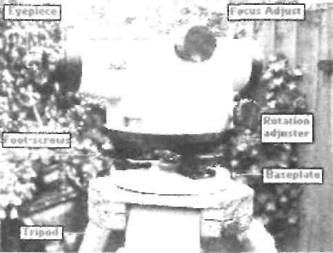
SURVEYING INSTRUMENTS
Theodolite
Сагтуїпд Handle Handle Screw <il
TriDrach Clamp Knob
OOTMCrttf
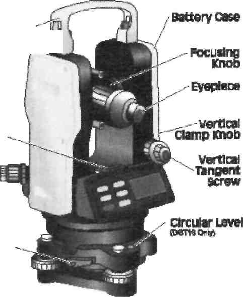
Theodolites - the most
widespread devices for
measurement of horizontal and
vertical corners. On a design
modern theodolites are subdivided
on optical, electronic and laser (an Plate Level
electronic theodolite with the built
in laser).
An optical theodolite - the
theodolite equipped with an
optical viewfinder and all
calculations are displayed in a
special optical window. The
optical theodolite is "the simple"
and reliable device.
Electronic theodolite - the theodolite equipped with the microprocessor and the display for display of all received data. These theodolites are much easier in use than optical. The built in computing functions simplify and accelerate work of the geodesist. Theodolites with the laser index it is the same electronic theodolites, but with the built in laser radiator which prompting on the purpose simplifies. On accuracy, on high-precision, with an average quadratic error of measurement of a corner one
reception to 1 ", exact - 2-5" and technical - 15-60 ". Basically theodolites are issued
with the jacks eliminating errors, caused by a device inclination in an operating time.
Depending on accuracy, theodolites can be used in a triangulation, in geodetic
networks of a condensation. Devices also have found application in an applied
geodesy, at carrying out of prospecting works. Besides, theodolites apply in the
industry at installation of elements of designs of cars and mechanisms, building of
industrial constructions and to performance of other problems.
Targeting Sight |
\rC~^l |
|
objective Lens, |
1 \ 1 1 |
instrument Center Mark |
Horizontal damp Knob |
|
|
Horizontal \ Tangents. \ . Screw \^ |
|
|
Display window^ Wm^tf |
Optical ^Plummet |
|
operating Keys--'" J рь |
|
|
Leveling screws |
jH Й£^с~!Z--3L |
Tripod —Baseplate |
Automatic and Laser Levels
Levels and Lasers
Line of sight
Graduate* Staff
Laser Line
/Л
Builders and the larger paving contractors will normally have an automatic or 'dumpy' level to assist them in the setting of site levels. The more up-to-date amongst them may even have a laser level which have become cheaper and more readily available over the past few years.
Both work on the same principle -
that the 'kit' is set up in such a way that
it defines a horizontal plane at a known
height around 360° from which
accurate measurements can be taken to
establish point levels. An automatic
level uses line of sight, albeit enhanced
somewhat via the telescope, while a
laser level emits a visible beam. Both
also rely on a graduated staff to
measure the difference between the
level plane and the point to be established.
The level unit is set-up in a position which gives a clear view of all points to be levelled, or as many as is feasible under site conditions. Each position where the level is set-up is referred to as a 'station', and stations may be marked for future reference by means of a timber peg, steel pin, brass tag or paint mark as befits the conditions. Marking of stations in this way allows levels and angles to be checked at a later date if a
discrepancy is found.
Staffs, Benchmarks
Once the surveying station is established, the relative height of the viewing plane needs to be determined. This is done by taking a measurement at a point which has a known level. This point is called a 'Benchmark' (BM). Levels established from this Benchmark to aid levelling elsewhere on the site are known Temporary Benchmarks' (TBM). A Benchmark may be a known
m
m
3
lot!
-1 OOmm
50mm
-lOmm
level, taken from a survey map or other official source, and given as a height in meters Above Ordnance Datum (AOD), which is usually taken as sea-level.
For smaller projects, though, the absolute height AOD is of little relevance; what matters arc the spot heights relative to a given point. For paving projects around the home, this given point will usually be floor level (FL) of the property, although it can be any fixed point whose height relationship with the works is known. For example, the FL of a garage could be used as the BM, as the paving has to be flush with the threshold of the garage floor and all other levels can be established from there.
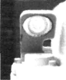
The Staff is held vertically on the BM and a measurement taken. With an automatic level, the surveyor will aim the telescope of
the level at the staff and adjust the / t Д_____1.35
focus until the scale on the / graduated staff can be clearly seen. A measurement is then read-off from the cross-hairs of the eyepiece and recorded. With a laser level, the visible laser line will strike the staff and a measurement can be read-off and recorded by the staff-bearer.
Most automatic levels have a magnification of around xlO, which makes the staff appear much nearer and larger than it would normally seen. Even at distances of 20m or so, it's fairly simple to read off a measurement to an accuracy of ±2mm.
In this example, a reading has been taken and recorded. The next step is to transfer this level to other key points on the project and make adjustments to suit the plans.
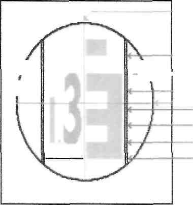
1.33 1.32m 1.31m 1.30m
'T HI
r-4
i:9
=-7 й
r-4
Surveying. Photogrammetry
1 .Surveying or land surveying is the technique and science of accurately determining the terrestrial or three-dimensional position of points and the distances and angles between them. 2.These points are usually on the surface of the Earth, and they are often used to establish land maps
and boundaries for ownership or governmental purposes.
3.Surveying has been an essential element in the development of the human environment since the beginning of recorded history (about 5,000 years ago). 4.1t is required in the planning and execution of nearly every form of construction. 5.Its most familiar modern uses are in the fields of transport, building and construction, communications, mapping, and the definition of legal boundaries for land ownership.
6.Hence modem surveying instruments are becoming more popular and they arc gradually replacing old surveying instruments such as compass and Dumpy level.
7.Photogrammetry is as old as modern photography and can be dated to the mid-nineteenth century.
8.Photogrammetry is used in different fields, such as topographic mapping, architecture. engineering, manufacturing, quality control, police investigation, and geology, as well as by archaeologists to quickly produce plans of large or complex sites and by meteorologists as a way to determine the actual wind speed of a tornado where objective weather data cannot be obtained.
9.Photogrammetry is the art science and technology of taking measurements off photographs.
10.The last decade or so has seen many advances made in the technologies associated with photogrammetry, and the microchip has had a major impact.
Геодезія. Фотограмметрія.
1. В останнє десятиліття чи протягом цього часу здобуто багато досягнень в технологіях, пов'язаних фотограмметрією і мікрочіп мав істотний вплив
2.Ці точки, як правило, на поверхні Землі, і вони часто використовуються, щоб розробити географічні карти і встановити межі власності або державних цілей.
3. Геодезія була важливим елементом у розвитку середовища проживання людини з початку історії людства (близько 5000 років тому). 4.Геодсзія та вимірювання землі є наукою точного визначення наземних або тривимірних положення точок і відстаней і кутів між ними. 5.Він необхідний у плануванні та здійсненні будь-якої форми будівництва. б.Тому сучасні геодезичних інструментів стають все більш популярними, і вони поступово приходять на зміну старим геодезичних інструментів, таких як компас і рівні
7.Фотограмметрії так само стара, як сучасної фотографії і можна віднести до середини дев'ятнадцятого століття. 8.Фотоірамметрія наукиа мистецтва та технології проведення вимірювань з фотографіями
9. Найбільш відоме сучасне використання у сферах транспорту, будівництва, зв'язку, відображення та визначення юридичних меж власності на землю.
10.Фотограмметрії використовується в різних областях, таких як топографічних карт, архітектурі, машинобудуванні, виробництва, контролю якості, поліцейське розслідування, і геології, а також археологами швидко створювати плани великих або складних об'єктів і метеорологами, як спосіб визначення фактичної швидкості вітру, торнадо, де об'єктивні дані погоди не можуть бути отримані.
Text 1. New era of geodesy
/. Read and memorize the following words:
accuracy - точність
appearance - поява
artificial - штучний
arc - дуга
available - наявний
celestial - небесний
computation - обчислення
constitute - складати
convenient - зручний
diametrically-діаметрально
dimension- розмір
ellipsoid - еліпсоїд
epoch - епоха
era - ера
evidence- доказ
feature - характерна особливість
geodesist - геодезист
geodesy - геодезія geodetic- геодезичний geodynamics - геодинаміка geoid - геоїд
gravimetric - гравіметричний inclination - нахил mean - середнє число measure - вимірювати micrometer - мікрометр observation- спостереження ocean - океан opposite - протилежний particularly- особливо possibility- можливість refer - посилатися technique - метод unreliable - ненадійний
// Expressions for the text comprehension:
as well - також
beyond the reach - поза межами
досяжності
classic arc measuring method- класичний
метод дугового вимір}'
coincidence spirit levels -суміщення кінців
спиртового рівня
control point system - система
контрольних точок
cylindrical axes - циліндричні вісі
earth satellite - супутник землі
face problems - стикатись з проблемами
focusing lenses - фокусуючі лінзи
glass circles - окуляр
global positioning system - система
глобального розташування
gravity measurements - гравітаційні виміри
gravity survey - гравітаційна зйомка
in order to - для того, щоб
in other words - іншими словами
matter -.мати значення
pendulum apparatus - маятниковий апарат
terra incognita - невідома країна
underwater gravi meter - підводний
гравіметр
Grammar Focus * - All geodetic instruments are being continually ...improved.
Пасивний стан дієслів (Passive Voice)
Часи дієслів у пасивному стані утворюються за допомогою дієслова to be у відповідному часі та дієприкметника минулого часу основного дієслова. Діслово в пасивному стані означає, що не сам підмет виконує дію, а над ним, для нього виконується
дія.
|
Indefinite |
Continuous |
Perfect |
Present |
Am (is.are) asked, written |
Am (is,are) being asked, written |
Have (has) been asked, written |
Past |
Was (were) asked, written |
Was (were) being asked, written |
Mad been asked, written |
Future |
Shall (will) be asked, written |
|
Shall (will) have been asked, written |
|
Якщо в реченні з дієсловом у пасивному стані вказується виконавець дії, то вживається прийменник by: The radio was invented by Popov in 1895. Якщо в реченні з дієсловом у пасивному стані вказується на предмет, знаряддя, яким виконується дія, вживається прийменник with: The tree was cut with an axe.
Дієслово в пасивному стані перекладається:
Земля була розкопана лопатою.дієсловом "бути" з дієприкметником: The ground was dug with a spade. -
1) Дієсловом із закінченням "-ся": The moon is used as a triangulation point. Місяць використовується як тріангуляційна точка.
2) Дієсловом у 3-й особі множини дійсного стану в неозначено-особовому реченні: Distances, angles, directions, areas and volumes are determined from data of the survey.-Відстані, кути, напрямки, місцеположення, площі та об'єми визначають з даних
5ЙОМК11.
3) Якщо дієслово вживається з прийменником, то переклад часто слід починати з прийменника: The film is much spoken about. - Про фільм багато говорять.
New era of geodesy
The 20th century opened a new era for geodesy. It had to do so because geodesy faced new problems which the classic methods were not able to solve. In earlier times most countries were satisfied to have their own geodetic control point system. For that purpose even poor dimensions of the earth and the classic arc measuring method were sufficient. It did not matter how much the control point systems of various countries differed from one another. During the last century, however, gcodesists had to join not only to the geodetic systems of various countries but of different continents as well.
Geodesy today is the science which carries out measurements with the accuracy that is beyond the reach of other branches of science. In order to do this wc must know the accuracy of the dimensions of the earth as well as its detailed shape. In other words, we must know the dimensions of the earth ellipsoid along which we carry out the computations of the control points
in different parts of the world, as well as the distances of the geoid from the earth ellipsoid and its inclination as referred to the ellipsoid.
Evidences of this new era are the celestial methods, the electronic measurement methods and the gravimetric methods, as well as the new types of measuring instruments and computing machines which were brought to science last century. All geodetic instruments are being continually developed and improved. New types of geodetic measuring instruments are lighter, smaller and more convenient to use than the old-fashioned instruments and they make observations two to three times faster.
Cylindrical axes, glass circles, focusing lenses, coincidence spirit levels, optical micrometers, and particularly the possibility of reading directly the mean of two diametrically opposite points of circles, are the most striking features of these new instruments.
The Vening Meinesz pendulum apparatus for gravity measurements at sea, the underwater gravimeter and other types of gravimeteres developed in the mid-20th century have brought a new epoch in the gravity survey of the globe. These new instruments permit the gravity survey of the oceans and seas, constituting 70 per cent of the whole area of the globe, which was in earlier times gravimetrically «terra incognita».
With the appearance of artificial earth satellites new era has begun in measuring techniques. The use of unreliable stars (seen only in clear nights) has been replaced by the use of artificial satellites which are available 24 hours a day and are located to our needs. Today we have Global Positioning System which is in general use and. is available on the whole earth 24 hours a day. This system is useful in many branches from navigation to the most accurate measurements in geodesy and gcodynamics.
Exercises
I. Give Ukrainian equivalents of the following international words from the text:
classic, methods, control, system, continent, detailed, distance, type, instrument, globe, global, navigation
//. Group the following word-combinations according to the model and translate them into Ukrainian:
Models: N + N - control point - контрольна точка, Л + N - geodetic system - геодезична
система
detailed shape, earth ellipsoid, celestial methods, electronic measurement, gravimetric methods,
measuring instruments, computing machines, geodetic instruments, glass circles, optical
micrometers, opposite points, cylindrical axes, focusing lenses, spirit levels, pendulum
apparatus, gravity measurements, underwater gravimeter, gravity survey, earth satellites,
measuring techniques, global system, accurate measurements
///. Find suffixes of:
classic, sufficient, various, geodesist, different, measurement, dimension, computation, inclination, electronic, gravimetric, continually, observation, cylindrical, coincidence, optical, particularly, possibility, directly, diametrically, gravimetrically, appearance, artificial, unreliable,
available, global, useful
IV. Give English equivalents of the following words and word combinations:
метод виміру, достатній, геодезичний, точність, еліпсоїд, віддаль, нахил, електронний, спостереження, зручний, спиртовий рівень, оптичний мікрометр, середнє число, вісь, фокусуючі лінзи, підводний гравіметр, маятник, океан, штучний супутник, геодинаміка,
зйомка
V. Read the text again, write out sentences with verbs in the passive voice and translate the
sentences.
VI. Comprehension questions;
l.What were the measuring methods in earlier times? 2. What does geodesy measure? 3. What parameters of the geoid do geodesists measure? 4. What methods were brought to geodesy in the 20th century? 5. What can you say about new types of geodetic instruments? 6. What are the features of new geodetic instruments? 7. How is the gravity survey caried out today? 8. Are stars reliable in geodetic measurements? 9. What has replaced the use of stars in geodetic measurements?
VII. What do you understand under the underwater gravimeter?
VIII. List the words describing the ocean survey.
IX. Annotate the second paragraph.
X. Speak about:
a) geodesy in earlier times,
b) new geodetic methods.
c) new geodetic instruments.
d) the use of artificial satellites in geodetic measurements.
Text 2. Surveying
I. Read aloud and memorize the following words:
actual - фактичний
angle - кут, plane - площина
area - площа, територія plumb - висок
boundary- границя, межа polygon - багатокутник, полігон
calculation - обчислення portray - зображувати
cross-section - поперечний переріз precision - точність
data - дані predetermined - заздалегідь визначений
draw -креслити profile - профіль
highway - шосе spheroidal. - сферичний
incidental - властивий straight - прямий
linear - ліпейний surface - поверхня
location - визначення місця, розташування surveying - зйомка, знімання.
magnitude - величина surveyor- землемір, вишукувач, топограф
neglect - нехтувати terrestrial - земний
//. Expressions for the text comprehension:
area involved - площа, що мається на увазі
as for - щодо, відносно
by far - набагато, значно
geodetic surveying - геодезична зйомка
level line -нівелірний хід
mean surface - середня поверхня
office work - камеральна обробка
plane angle- плоский кут
plane surveying - інженерна зйомка,
топографічна зйомка
plumb line - висок
progress of survey - процес зйомки relative location - відносне розташування
take into account - брати до уваги
take measurements - проводити виміри,
знімати відмітки
terrestrial lines - земні лінії
terrestrial objects - земні об'єкти
to a greater or lesser degree - в більшій чи
меншій мірі
with regard to - щодо, відносно
within limits - в межах
Grammar Focus
• shaft plumbing
Іменник з лівими означеннями
Аналізуючи та перекладаючи синтаксичну групу, що складається з іменника та лівих означень, слід пам'ятати, що останнє слово є основним, а інщі слова будуть означеннями до нього. Переклад частіше всього треба починати з основного слова. Shaft plumbing is a special problem. - Встановлення за високом в стволі шахти є окремою
проблемою.
Surveying
Surveying has to do with the determination of the relative location of points on or near the surface of the earth. It is the art of measuring horizontal and vertical distances between terrestrial objects, of measuring angles between terrestrial lines, of determining the direction of lines, and of establishing points by predetermined angular and linear measurements.
Incidental to the actual measurements of surveying are mathematical calculations. Distances, angles, directions, locations, areas and volumes are thus determined from data of the survey. Also, much of the information of the survey is portrayed graphically by the construction of maps, profiles, cross-sections and diagrams.
Thus, the process of surveying may be divided into the field work of taking measurements and the office work of computing and drawing necessary to the purpose of the survey.
The earliest surveys known were for the purpose of establishing the boundaries of land, and such surveys are still the important work for many surveyors.
Every construction project of any magnitude is based to a greater or lesser degree upon measurements taken during the progress of a survey and is constructed about lines and points established by the surveyor.
Plane surveying. That type of surveying in which the mean surface of the earth is considered a plane, or in which its spheroidal shape is neglected, is generally defined as plane surveying. With regard to horizontal distances and directions, a level line is considered as mathematically straight. The direction of the plumb line at any point within..the limits of the survey is considered as mathematically straight . The direction of the plumb line at any point
within the limits of.the survey is considered as parallel to the direction of the plumb line at any other point, and the angles of polygons arc considered as plane angles.
By far the greater number of all surveys are of this type. Surveys for the location and construction of highways, railroads, canals are plane surveys, as arc also the surveys made for the purpose of establishing boundaries, except state, provincial and national.
Geodetic surveying. That type of surveying which takes into account the shape of the earth is defined as geodetic surveying. All surveys employing the principles of geodesy are of high precision and generally extend over large areas. Where the area involved is not great, as for a province, state, the required precision may be obtained by assuming that the earth is a perfect sphere. Where the area is large, as for a country, the true spheroidal shape of the earth is considered.
Exercises
I. Give Ukrainian equivalents of the following international words from the text:
horizontal, vertical, distance, line, mathematical, information, construction, profile, diagram, process, project, base, construct, parallel, type, canal, national, principle, sphere.
//. Read the text again, write out terminological words, explain their structure and translate them into Ukrainian:
III. Explain the difference between the terms p I a n e s urv є у і п g and g e odetic surveying.
IV. Read the text again, write out sentences with verbs in the passive voice and translate them into Ukrainian.
V. Give English equivalents of the following words and word combinations:
об'єм, карта, обчислювати, польова обробка, будівельний проект, земля, сферична форма, площа, потрібна точність, залізна дорога, припустити, досконала сфера, взагалі, визначити.
VI. Comprehension questions:
І. What has surveying to do with? 2. What follows measurements of surveying? 3. Into what work ia the process of surveying divided? 4. When is the survey information portrayed graphically? 5 What were the earliest surveys? 6. In what surveying is the spherical shape of the earth neglected? 7. What are characteristic features of plane surveying? 8. What can you say about the plumb line in the plane surveying? 9. What surveying is used for highways and roads? 10. When is the spheroidal shape of the earth considered in surveying? 11. What is measured in surveying?
VII. Make the plan of the text.
VIII. Find in the text a sentence describing the earliest surveys.
IX. List the words describing geodetic surveying.
X. Speak about:
a) field work in surveying
b) office work in surveying
Text 3. Location
/. Read and memorize the following words:
accepted- загальноприйнятий, визнаний
activity - діяльність
astride - по обидва боки, вздовж
attribute - ознака
border - межувати
degree - градус
direction - напрямок
external - зовнішній
interdependence - взаємозалежність,
взасмозв* язок
interior - внутрішня частина країни
intersection - перетин,
legal - правовий, юридичний
locale - місце знаходження
longitude - довгота
lowland - низина, долина
margin - край
minute -мінута
//. Expressions for the text comprehension:
movement - pyx
particular - особливий
penetration - проникнення
personal - особистий
pinpoint точно визначати
precise - точний
range - межа, пасовисько
reference - посилання, довідка
relationship - зв'язок
seaboard - узбережжя
site - місцеположення, місцезнаходження,
місцеперебування
situation - місце, місцеположення
spatial -• просторовий
township - містечко, селище
unique - унікальний
waterway - водний шлях, водопротока
according to - згідно з, відповідно до
at least - принаймні
be in use - вживатись
corn belt - кукурудзяний пояс
for example - наприклад
global grid - глобальна сітка, мережа
in relation to -по відношенню до
in view of - у зв'язку з, беручи до уваги
internal feature - внутрішня особливість
items of significance - важливі пункти,
особливості
make a distinction - розрізняти
manufacturing belt - виробничий пояс,
зона
on a regional level - на регіональному
рівні
on the other hand - з іншого боку
place in question - обговорюване місце
starting point -. початковий момент
Grammar Focus
*We have several ... systems of pinpointing positions.
*The site of Philadelphia ... is an area bordering ... the Delaware river.
* We have a better understanding of the problem.
Indefinite Gerund, Present Participle and Verbal Noun
Проста форма герундія, дієприкметника та віддієслівного іменника мають однакове закінчення - ing, проте відрізняються синтаксичними функціями та відповідно перекладом.
Indefinite Gerund може бути: 1)підметом: Working in constricted places requires the use of special devices. - Праця в звужених місцях потребує використання спеціальних приладів.
2)частиною іменного присудка: Our aim is learning to use geodetical devices. - Наша мета -навчитись використовувати геодезичні прилади.
Зазначенням: There are different ways of looking at location. - Є різні способи розглядати місце розміщення.
4)додатком: Go on reading. - Продовжуйте читати.
5)обставиною: Absolute location is utilized in finding directions. - Абсолютне місцезнаходження використовують при визначенні напрямків.
Герундій часто вживається після прийменників. Частіше всього він перекладається іменником, неозначеною формою дієслова.
Present Participle (Participle 1) (дієприкметник теперішнього часу) в реченні може бути: 1)обставипою: Testing the device we write down the readings. - Випробуючи прилад, ми записуємо показники.
2)означенням перед означуваним словом: The levelman examined the moving target. -Нівелювальник оглянув рухомий повзунок.
3)означенпям після означуваного слова: Transits having a vertical arc are called engineer's (or surveyor's) transits. - Теодоліти, що мають вертикальну дугу, називаються інженерними теодолітами.
4)частиною дієслівного присудка: Don't make noise, he is sleeping. - He шуміть, він спить. Present Participle частіше всього перекладається дієприкметником, дієприслівником чи особовою формою дієслова.
Verbal noun (віддієслівний іменник) мас перед собою артикль або означення чи стоїть в множині: the rising and the setting of the sun - схід та захід сонця.
We have several systems of pinpointing positions. - Є декілька систем точного визначення позицій.
The site of Philadelphia ... is an area bordering ... the Delaware river. - Територія Філадельфії - це площа, що межує з рікою Делавар. We have a better understanding of the problem. - Ми краще розуміємо цю проблему.
Location
The location of places and things is the starting point of all geographic study as well as of all our personal movements and spatial actions in everyday life. We think of and refer to location in al least two different senses, absolute and relative. Absolute location is the identification of place by some precise and accepted system of coordinates, it therefore is sometimes called mathematical location. Wc have several such accepted systems of pinpointing positions. One of them is the global grid of latitude and longitude. With it the absolute location of any point on the earth can be accurately described by reference to its degrees, minutes, and seconds of latitude and longitude. Other coordinate systems are also in use. Survey systems such as the township,
range, and section description of property give mathematical locations on a regional level, while street address precisely defines a building according to the reference system of an individual town. Absolute location is unique to each described place, is independent of any other characteristic or observation about the place, and is utilized in the legal description of places, in measuring the distance separating places,or in finding directions between places on the earth's surface.
When geographers remark that "location matters", however, their reference is not to absolute but to relative localion - the position of a place in relation to that or other places or activities. Relative location expresses spatial interconnection and interdependence.
New York City, for example, may in absolute terms be described as located at latitude 40° 43' N and longitude 73° 58' W. We have a better understanding of the meaning of its location, however, when reference is made to its spatial relationships: to the continental interior through the Hudson-Mohawk lowland corridor or to its position on the eastern seaboard of the United States.In view of different ways of looking at location geographers make a distinction between the site and the situation of a piece. Site refers to the physical and cultural characteristics and attributes of the place itself. It is more than mathematical location, for it tells us something about the internal features of that place. The site of Philadelphia, for example, is an area bordering and west of the Delaware river, north of its intersection with the Schuylkill river in southeast Pennsylvania. Situation, on the other hand, refers to the external relations of a locale. It is an expression of relative location with particular reference to items of significance to the place in question. The situation of Chicago might be described as at the deepest penetration of the great lakes system into the interior of the United States, astride the Great Lakes-Mississippi waterways, and near the western margin of the manufacturing belt, the northern boundary of the corn belt.
Exercises
I. Give Ukrainian equivalents of the following international words from the text:
geographic, action, absolute, identification, system, position, minute, second, regional, address, individual, characteristic, distance, activity, continental, corridor, physical, cultural
//. Give the roots of the words:
starting, movement, personal, spatial, action, accepted, global, township, description, regional, precisely, building, reference, independent, observation, direction, activity, interconnection, location, understanding, meaning, relationship, intersection, expression, penetration, western, northern, boundary
///. Read the text again, find sentences with participle 1 and gerund and translate them.
IV, Read the following word combinations and translate them:
coordinate systems, survey systems, street address, reference system, lowland corridor, Great Lakes system, corn belt, Great Lakes-Mississippi waterways
V. Analyse the S-P-0 structure of the sentence:
Relative location expresses spatial interconnection and interdependence.
VI. Finish the sentences according to the text:
1. We have several accepted systems of.....2. Relative location expresses ...
VII. Comprehension questions:
l.What is the starting point of all geographic study? 2. In what senses do we think of location? 3. What is absolute location? What is another name for absolute location? 4. When is absolute location used? 5. What are methods of absolute location? 6. What is relative location? 7. Where is New York City located in absolute terms? 8. What is the relative location of New York City? 9. What does the term site refer to? 10. What does the term situation refer to? 11. What is the situation of Chicago?
VIII. Find in the text a sentence describing the site of Philadelphia.
IX. Speak about;
a) absolute location;
b) relative location;
c) geographic location of New York City;
d) distinction between site and situation of a place;
e) situation of Chicago.
Text 4. Direction
/. Read aloud, and memorize the following words;
commonly - звичайно
custom - звичай
derive - походити, одержувати
despite - незважаючи на
generation - покоління
given - дане
obvious - очевидний
reflection - відображення, відбиття,
рефлексія
retain - утримувати, зберігати, пам'ятати
rising - схід
setting - захід
uniformly - однорідно, рівномірно
usage - вживання
variable- змінний, мінливий, несталий
westward - спрямований на захід, на захід
worry - турбуватись
//. Expressions for the text comprehension :
absolute direction - абсолютний напрямок
cardinal point - сторона світу
directional reference - посилання на
напрямок
far east - далекий схід
migration path - шлях міграції noontime sun - полуденне сонце relative direction- відносний напрямок sky location - знаходження сонця spatial concept - просторове поняття
Direction
Direction is a second universal spatial concept. Like location, it has more than one meaning and can be expressed in absolute or relative terms. Absolute direction is based upon the cardinal points of north, south, east, and west. These appear uniformly and independently in all cultures, derived from the obvious "givens" of nature: the rising and setting of the sun for east and west, the sky location of the noontime sun and of certain fixed stars for north and south. We also commonly use relative or relational directions. In the United States we go "out west", "back east", or "down south"; we worry about conflict in the "near east", or economic competition from the "far eastern countries". These directional references are culturally based and locationally variable, despite their reference to cardinal compass points. The near and far east locate parts of Asia from the European perspective, they are retained in the Americas by custom and usage, even though one would normally travel westward across the pacific, for example, to reach the "far East'" from California, British Columbia, or Chile. For many Americans, "back East", and "out West" are reflections of the migration paths of earlier generations for whom home was in the eastern part of the country, to which they might look back. "Up North" and "down South" reflect our accepted custom of putting north at the top and south at the bottom of our maps.
Assignments
1. Comprehension questions:
l.What is a second universal spatial concept? 2. What is absolute direction? 3.What is absolute direction derived from? 4. What are relative directions based on? 5. From what perspective are parts of Asia located? 6. What were migration paths of earlier Americans? 7. What is the custom
of putting North and South on maps?
2. Give a short summary of the text.
3. Discuss the content of the text in the form of a dialogue.
Text 5. Transit and its adjustments
/. Read and memorize the following words:
altitude - висота lack - невистачати
appear - з'являтись, очевидно, напевно level(v) - вирівнювати, нівелювати
attach - приєднувати lie - лежати
clamp - зажим, закріплювати, закріпний loosen - послабляти
гвинт motion - рух
eyepiece- окуляр opposite - протилежний
fall - попадати proceed - переходити, продовжувати
fasten - закріплювати reflector - рефлектор, дзеркало
fit - підганяти всередину rotate - повертати
head -. головка set up - встановити
illuminate -. освітлювати spindle - вісь, круг
invert — перевертати, переставляти standard - стійка, підставка
tap - постукати telescope - труба теодоліту tighten - затягувати transit - теодоліт
travel - пересуватись turn - повертати upper - верхній vernier - верньєр
11. Expressions for the text comprehension:
apparent error - наявна помилка
as follows - як нижче зазначено
bubble tube - трубка круглого рівня
capstan screw- виправний гвинт
circular plate - кругла пластина
compound objective - складний об'єктив
cross-hair ring - сітка ниток
erecting transit - теодоліт з прямим
зображенням
graduated circle - градуйований круг
leveling screw - підйомний гвинт
line of sight - лінія візування
lower plate - нижня пластина
opposing screws - виправний гвинт
plate bubble - вісь рівня
stadia hairs - горизонтальні паралельні
нитки в теодоліті
tangent screw -мікрометренний гвинт
telescope tube - труба теодоліту
upper plate - верхня пластина
Transit and its adjustments
An engineer's transit has two spindles, one fitting inside the-other, to each of which is fastened a horizontal circular plate.Anothcr spindle is attached to a lower plate, on which is a graduated circle, and the inner spindle carries an upper plate, to which the verniers and standards holding the telescope are attached. The motion of these horizontal plates is controlled by clamps and tangent screws. On the upper plate are two spirit levels, the plates are levelled by 4 (sometimes 3) levelling screws.
Transits having a vertical arc are called engineer's (or surveyor's) transits A plain transit lacks these attachments.
A telescope has a compound objective and an eyepiece composed of 4 lenses, if the instrument is an erecting transit, two lenses if inverting. An inverting instrument gives a much better illuminated field. Between the objective and eyepiece is the cross-hair ring held in its concentric position by four opposing screws, the heads being outside the telescope tube.
Special attachments ar:; a) a dark eyepiece for observing the sun; b) a diagonal or a prismatic eyepiece for sighting high altitudes; c) a reflector attached to the telescope for illuminating cross-hairs when working in the dark; d) stadia hairs which are two extra horizontal cross-hairs for measuring distances by stadia.
Adjustments of the transit are: a) to make the plane of plate bubbles perpendicular to the vertical axis of the instrument, b) to make line of sight perpendicular to the horizontal axis; c) to make the horizontal axis perpendicular to the vertical axis of the instrument.
Bubble tubes.__ Bring plate bubbles to centers of respective tubes by turning levelling screws. Turn 180° and correct half of the apparent error by turning capstan screws of bubble tubes. Adjust each bubble independently.
Line of sight. First, adjust the vertical cross-hair to lie in the plane perpendicular to the horizontal axis. Set up and level the instrument. Sight the vertical hair on a well defined point. Clamp both plates, and move the telescope up and down. If the point does not appear to travel along a vertical cross-hair loosen screws holding a cross-hair ring, and by tapping lightly on one
screw, rotate the ring until the above condition is fulfilled. Then tighten screws and proceed with the second part of adjustment as follows: sight the telescope at point A (200 to 300 ft. away), and clamp the vertical axis; invert the telescope on its horizontal axis and set point В at about the same elevation as A, in line of sight, and about the same distance from the instrument as A. Loosen the clamp, turn horizontally and sight A again; damp horizontal motion, invert the telescope on the horizontal axis and if line of sight falls on В it is in adjustment. If not, set point C in line of sight beside point B. Mark or note point D one-fourth the distance between C and B, measured from C. To adjust, move the cross-hair ring until D is intersected, by loosening the screw on one side of the telescope and tightening an opposite one.
Exercises
/. Give Ukrainian equivalents of the following international words from the text;
concentric, diagonal, prismatic, perpendicular, center, control, engineer, special, correct
//. Find in the text adjective + noun word-combinations and translate them into Ukrainian.
Ill Write out of the text word combinations consisting of two nouns.
IV. .Find sentences with participle I and gerund and translate them,
V. Finish the sentences according to the text:
1 .Between the objective and the eyepiece is.....2. On the upper plate..... 3.Clamp both plates
and.....
VI. Group the words to correspond to the sequence of the key items in the text:
clamp, levelling, screw, horizontal axis, perpendicular, dark eyepiece, bubble
VII. Comprehension questions:
1.Where is a horizontal circular plate fastened? 2. How many spindles has the transit? 3. How is the motion of horizontal plates controlled? 4. 'Where are spirit levels situated? 4. How many lenses has an erecting transit? 5. What is the difference between the erecting and inverting transits? 6. Where is the cross-hair ring situated? 7. What are special attachments in the transit? 8. What is a reflector used for? 9. What is the attachment for sighting high altitudes? 10. What is the position of the vertical cross-hair in line of sight? Ii. When do you loosen screws holding a cross-hair ring?
VIII. Speak about:
.a) a telescope;
b) special attachment of a transit,
c) bubble lubes.
d) procedure of adjusting line of sight.
Text 5. Figure and size of the earth
l.Read and memorize the following words:
above - над accuracy - точність approximation- наближення base (v) — базувати below - під circle (n) - коло closely - тісно consider — розглядати correspond - відповідати cut (v) - перерізати define - визначати degree - градус depth - глибина difference -різниця distribution - розподіл elevation - підвищення, висота figure - фігура
improve -. покращати
intersect - перетинати
measure (v) - вимірювати
need (v) - потребувати
normal - перпендикулярний
pass (v) - проходити
plane (n) - площина
point - точка, крапка
relate - бути зв'язаним, мати відношення
represent - представляти
size - розмір
sphere - сфера
state (v) - констатувати, формулювати
subject (a) - що підлягає
suitable - придатний
various - різний
11. Expressions for the text comprehension:
accurate observations - точні
спостереження
angular coordinates - кутові координати
angular distance - кутова відстань
axis of rotation - вісь обертання
ellipse of rotation - еліпс обертання,
еліпсоїд
empirical equation - емпіричне рівняння
in practice - на практиці
land masses - маєм суші, землі
linear distance - лінійна відстань
linear unit - лінійна одиниця
mean sea level - середній рівень моря,
умовний горизонт
Grammar
meridian plane - площина меридіану
oblate spheroid- сплющений сфероїд
parallels of latitude - паралелі широти
plumb line - висок
reference level - рівнева поверхня,
контрольний рівень
royal observation - королівська
обсерваторія
system of coordinates - система координат
that is - тобто
unit difference - питома різниця
vertical distance — вертикальна відстань
Focus
*Any plane parallel to the Equator cuts the surface of the spheroid in a circle, all points on this circle having the same latitude.
Незалежний (абсолютний) дієприкметниковий зворот (The Absolute Participle Construction)
Складається з іменника в загальному відмінку або займенника в називному відмінку та дієприкметника. Може стояти перед головним реченням або після нього та відокремлюється комою. Перекладається підрядними реченнями часу, умови, причини,
супутніх обставин із сполучниками після того як; коли; так, як; оскільки; якщо та іншими в першому випадку або самостійним реченням із сполучниками причому;а; і в другому. The weather permitting, we shall go to the park. - Якщо погода дозволить, ми підемо в парк. The treaty is done in the Russian and Chinese languages, both texts being equally valid. - Угода складена на російській та китайській мовах, причому обидва тексти мають одн акову силу.
Any plane parallel to the Equator cuts the surface of the spheroid in a circle, all points on this circle having the same latitude. - Будь-яка площина, паралельна екватору, перерізає сфероїд колом, причому всі точки при цьому мають однакову широту.
Figure and size of the earth
As a first approximation the earth may be considered as a sphere, but according to accurate observations, its figure is more closely represented by an ellipse of rotation - that is, an oblate spheroid, the shorter axis being the axis of rotation. The figure of the earth has been defined by various empirical.equations, the constants of which being based on observations and being subject to modification as the number of observations increases and their accuracy is improved. The geometrical figures defined by these equations cannot exactly represent the shape of the earth because of the a symmetrical distribution of the water and land masses.
To define the position of a point on the earth's surface a system of coordinates is needed, and as such the terms latitude, longitude and elevation or depth are used. The first two are expressed by angular coordinates and the third is expressed by the vertical distance, stated in suitable linear units, above or below a reference level that is closely related to mean sea level. The latitude of any point is the angle between the local plumb line and the equatorial plane. Because the earth can be considered as having the form of a spheroid, and as the plumb line, for all practical purposes, is perpendicular to the surface of the spheroid, any plane parallel to the equator cuts the surface of the spheroid in a circle, . all points on this circle having the same latitude. These circles are called parallels of latitude. The latitude is measured in degrees, minutes, and seconds north and south of the equator, the linear distance corresponding to a difference of one degree of latitude would be the same everywhere upon the surface of a sphere, but on the surface of the earth the distance represented by a unit of latitude increases by about 1 per cent between the equator and the poles.
The line in which the earth's surface is intersected by a plane normal to the equatorial plane and passing through the axis of rotation is known as a meridian. The angle between two meridian planes through two points A and В on the surface of the earth is the difference in longitude of the two points. In practice, the longitude is the angular distance measured in degrees, minutes, and seconds east or west from a standard meridian plane, generally that of the royal observatory at Greenwich, England. Thus, the longitude is measured from 0° to 180° east and west of Greenwich. On the surface of the earth the linear distance equivalent to unit difference in longitude is nearly proportional to the cosine of the latitude.
The distance between points on the earth's surface and the area represented by a given zone cannot be correctly represented unless the size of the earth is known.
Exercises
/. Give Ukrainian equivalents of the following international words from the text:
figure, sphere, ellipse, rotation, empirical, constant (n), modification, geometrical, asymmetrical, mass, position, system, coordinate, vertical, distance, local, line, equatorial, form (n), spheroid, practical, perpendicular, parallel, equator, minute, second(n), per cent, pole, meridian, observatory, equivalent, cosine, zone
//. Find in the text adjective + noun, noun + noun word combinations and translate
III. Give the opposites of::horizontal, short, above, various, north, east, high, wide, inner.