

Экзамен зачет учебный год 2023 / Stoter, Ploeger, Multiple Use of Space. Current practice of Registration and Development of a 3d Cadastre
.pdfSession I |
The Third Dimension |
MULTIPLE USE OF SPACE:
CURRENT PRACTICE OF REGISTRATION
AND DEVELOPMENT OF A 3D CADASTRE
JANTIEN E. STOTER & Hendrik D.Ploeger
Department of Geodesy
Faculty of Civil Engineering and Geosciences
Delft University of Technology
The Netherlands
ABSTRACT
A cadastral registration system provides insight in rights and limited rights related to (2D) parcels. In case of multiple use of space, the 2D parcel has shown its limitations. To illustrate this we describe two cases in this paper. At our Department a research is carried out in collaboration with the Netherlands’ Kadaster to study the 3D issue of cadastral registration in a fundamental way. During this research a prototype of a 3D cadastre is being developed, in which rights established on 2D parcels can be represented in 3D (3D right-objects). We give a description of this prototype and demonstrate that the introduction of 3D right-objects improves the insight in the vertical component of rights considerably by applying this concept to the described cases. Future research will focus on defining the 3D right-objects more precisely in 2D and 3D (geometrically as well as topologically) and on the registration of 3D physical objects (objects as they occur in the real world). The last will require more drastic adjustments in the current cadastral registration system.
INTRODUCTION
The traditional cadastre is based on a division of land in 2D parcels. Ownership rights and limited real rights on land are registered on these parcels. The question can be raised if this “flat world” is satisfactory. After all, it cannot be denied that the dimensions of real rights on land are not only fixed in 2D, by the boundaries of the parcel. These rights have also a spatial component in the third dimension, in height and depth. The right of ownership reaches from the middle of the earth up to the sky, according to the Latin maxim: ‘cujus est solum ejus est usque ad coelum et ad inferos’.
So why is the cadastre flat? The answer must be that in far most cases the representation of a 3D legal reality in a flat 2D cadastre is sufficient. There is no need to add the third dimension to this kind of geo-information. The spatial component is not important as far as only one person (or group of persons) is entitled to the parcel. This is also the case in the situation that the owner has established a limited real right (ius in re aliena) on his land, like usufruct. The owner is restricted in the use and enjoyment of his property by the existence of this limited right. The holder of the limited right may claim control of the land in so far as it is necessary for the effective exercise of his right. As a general rule he has the right to hold and use all of
© UDMS 2002 |
I.1 |

Session I |
The Third Dimension |
the land during the time the right is granted. The owner of the land is left with the dominium nudum, a restricted ownership until the moment he will regain the full ownership by extinction of the limited right (Kleyn and Borraine, 1992).
However, in particular cases, it is not so obvious that a cadastre should be flat. These we call “complex situations”. Cases of multiple use of space: one parcel is used by several people - full owners and/or holders of limited real rights - each holding a right on the parcel, each right limited in the third (and second) dimension. For example: a building is divided in several apartments, and they belong to different owners. Or the owner of a railway line grants someone the right to erect an office block 10 meters above the tracks. Other examples of multiple use of space are tunnels, pipelines, cables and underground extraction of minerals.
Can a 2D cadastre really cope with these situations?
Registration of ownership in complex situations
According to the Articles 20 and 21 of Book 5 of the Dutch Civil Code (1992) the right of ownership of land reaches from the middle of the earth up to the sky. Also ownership of land comprises the buildings and works forming a permanent part of the land. Horizontal division of ownerships rights is possible by establishing rights and limited rights on surface parcels, such as a right of superficies or apartment ownership (Nieper and Ploeger, 1999; Stoter, 2000).
In cases of multiple use of space the Netherlands’ Kadaster registers the ownership and limited rights just on the flat, 2D parcels. As we will demonstrate, this kind of registration has limitations to give a clear representation of the 3D component of the concerning rights.
In 2000 the Department of Geodesy of the Delft University of Technology started a research to study the needs and possibilities of the registration of multiple use of space in a 3D cadastre. This research is carried out in collaboration with the Netherlands’ Kadaster.
As part of this research we investigated four cases from practice, of which we will present two in this paper:
-“Den Haag Centraal”: a building complex in the city centre of The Hague;
-a small apartment complex.
We start with a short overview of the current registration practice in the Netherlands. This background knowledge is needed to understand the two cases. For each of these cases we examine first the actual registration of the property rights. How does the Netherlands’ Kadaster deal with multiple use of space at this moment? Next we discuss the need of a registration in 3D. What problems rise with the representation of the legal situation in 2D in each of the cases?
During the research a concept of a 3D cadastre has been developed, as well as prototype implementations. We give a description of these implementations and then we will apply the prototype implementations to the cases. In our conclusion we examine if the developed concept and the proposed implementations offer improvements for the problems mentioned.
© UDMS 2002 |
I.2 |

Session I |
The Third Dimension |
CURRENT REGISTRATION PRACTICE
Registration by the Netherlands’ Kadaster
The Netherlands’ Kadaster bears the responsibility for the cadastral registration in the Netherlands: the registration of the parcel boundaries and the registration of the legal status of the parcels. This system consists of (Lemmen et al, 1998):
-a 2D geo-DBMS for maintaining the geometry and topology of parcels (and buildings for reference purposes) called LKI (Landmeetkundig Kartografisch Informatiesysteem, ‘Information system for Surveying and Mapping’)
-an administrative DBMS for legal and other administrative data related to parcels called AKR (Automatisering Kadastrale Registratie, ‘Automated Cadastral Registration’)
The Kadaster also maintains the Public Registers (Openbare registers): a registration of notarial deeds creating or transferring real rights to land. These deeds are registered and archived in chronological order. The cadastral registration system makes the information in the deeds referring to individual parcels accessible.
CASES
We will now describe two cases to show how complex situations are registered within the current cadastral registration system.
Case 1: Den Haag Centraal
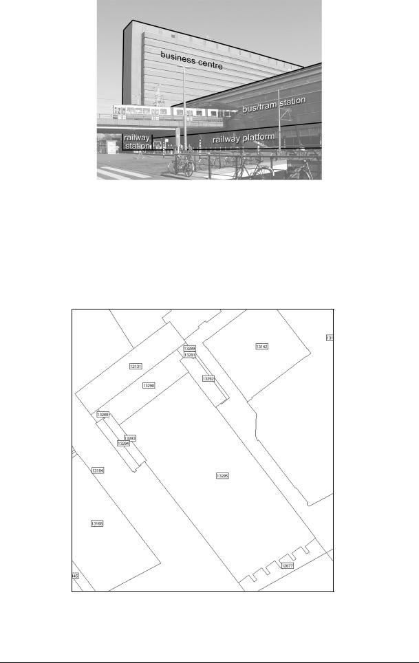
“Den Haag Centraal” is a building complex in the city centre of The Hague. It is a combination of a multi-floor public transport interchange (bus/tram station and railway station), an office centre and shops (see figure 1). All parts of this complex are owned by different companies. This is achieved by dividing the high building (office and railway station) in apartments rights, and the establishment of a right of superficies for the bus/tram station.
The use of apartment rights will be discussed in more detail in the second case. Here we take a closer look at the right of superficies (opstalrecht). A right of superficies is a limited real right that entitles its holder to build and have a building (or an other type of construction) in, on or above the land owned by another. As a limited real right it restricts the landowner in his use: he has to tolerate the existence of the building. On the other hand, the holder of the right of superficies is the full owner of the erected building. In the case of Den Haag Centraal, the holder of the right of superficies is entitled to build the tram and bus station on top of the railway platforms.
© UDMS 2002 |
I.3 |
Session I |
The Third Dimension |
Figure 1: Den Haag Centraal. Combination of a business centre, a railway station and a bus/tram station.
The cadastral map of this complex is shown in figure 2. The bus/tram station on top of the railway platform is erected on parcel ‘13295’, the business center is on top of the railway station on parcel ‘12131’.
Figure 2: The cadastral map of ‘Den Haag Centraal’.
© UDMS 2002 |
I.4 |
Session I |
The Third Dimension |
According to the cadastral DBMS, the right of the concerning parcels are as follows:
PARCEL KIND_OF_RIGHT RIGHT_OWNER
------- ------------- |
------------ |
||
12131 |
|
VE |
VERENIGING VAN EIGENAREN STICHTHAGE TE ’S-GRAVENHAGE |
|
|
--(divided into two apartments: 12205A0001 and 12205A0002) |
|
12205A0002 |
VE |
STICHTHAGE TRUST B.V. GEV. TE'S-GRAVENHAGE |
|
12205A0001 |
VE |
NS VASTGOED BV |
|
13288 |
|
VE |
NS VASTGOED BV |
13289 |
|
VE |
NS VASTGOED BV |
13290 |
|
VE |
NS VASTGOED BV |
13291 |
|
EVOS |
NS VASTGOED BV |
13291 |
|
OS |
Gemeente Den Haag |
13292 |
|
EVOS |
NS VASTGOED BV |
13292 |
|
OS |
Gemeente Den Haag |
13293 |
|
EVOS |
NS VASTGOED BV |
13293 |
|
OS |
Gemeente Den Haag |
13294 |
|
EVOS |
NS VASTGOED BV |
13294 |
|
OS |
Gemeente Den Haag |
13295 |
|
EVOS |
NS Railinfratrust BV |
13295 |
|
OS |
Gemeente Den Haag |
VE |
= full right of ownership |
||
OS |
= right of superficies |
||
EVOS = right of ownership, restricted by a right of superficies
Analyzing these data, it is clear which persons have a right on the concerning parcels. So, for instance for the parcel 13295 it shows that “NS Railinfratrust BV” is owner of the land (with the railway platforms), and that the municipality of The Hague (in Dutch: gemeente Den Haag) is holder of the right of superficies (tram/bus station). However, neither these data nor the cadastral map give insight how on every single parcel the rights are divided in the vertical dimension. Even there is no indication in the cadastre that the municipality is the full owner of the bus/tram station. A study in the Public Registers did not reveal much more information. Except for parcel 12131 (divided in apartment rights), the concerning deeds do not contain a spatial description or a (clear) drawing to clarify the division in ownerships rights on every parcel.
Case 2: Apartment complex
A typical form of multiple use of space, known in Dutch law since 1953, is apartment ownership (condominium ownership).
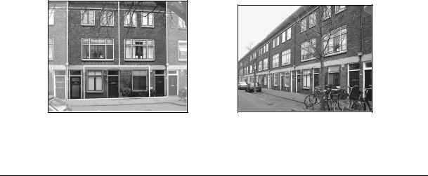
For this case, we used a ‘simple’ apartment complex, consisting of one ground parcel and three apartments. One apartment is located on the ground floor, and the two other apartments are located on the second and third floor, next to each other, with an entrance on groundlevel (see figure 3).
Figure 3: Example of an apartment complex (left) and an overview of the whole street (right).
© UDMS 2002 |
I.5 |
Session I |
The Third Dimension |
In Germany, France and the most other European countries the legislation on apartment ownership is based on the so-called “dual system” (Van Velten and Aldrigde, 1996). Every apartment owner has the full ownership of a part of the building (apartment). The communal areas of the building, such as staircases and elevators are held in co-ownership. This can be described as compulsory co-ownership, or an accessory restricted co-ownership. “Accessory” because it cannot be separated from the ownership of the apartment, “restricted” because during the time the building is divided into apartments, the separation and division of the common areas is not possible.
Three European countries have adopted the “unitary system”: Austria, Swiss and the Netherlands (Van Velten and Aldridge, 1996). It is important to notice that in this system the apartment ownership is based on co-ownership of the whole complex. As we shall see this is reflected in the way apartment ownership is registered in the Netherlands’ Kadaster.
Article 106 of Book 5 of the Dutch Civil Code (1992) describes apartment ownership (or apartment right (apartemensrecht) as follows:
“3. An apartment right means a share in the property involved in the division which comprises the right to exclusive use certain parts of the building which, as indicated by their lay-out, are intended to be used as separate units. The share can also include the right to exclusive use of certain parts of the land pertaining to the building.
4.An apartment owner means a person entitled to an apartment right.“
So the owners are joint owners of the entire building and the underlying ground. This coownership includes the right to have the exclusive use of a certain part of the building, the apartment.
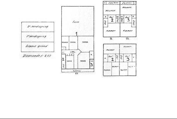
The division in apartment rights is based on a notarial deed, the so-called “deed of division” (splitsingsakte). A (scanned or analogue) plan is obliged in this deed. This plan gives an overview of the building and a detailed plan of each floor. Thick dark lines indicate the borders of every apartment, that is the area of exclusive use. The individual apartments are numbered (see figure 4).
(A) |
(B) |
(C) |
Figure 4: Drawing belonging to the deed of division of the apartment complex in figure 3, with A: cross-section, B: first floor, C upper: second floor and C lower: third floor.
The individual apartments are indicated by ‘1’,’2’ and ‘3’.
© UDMS 2002 |
I.6 |

Session I |
The Third Dimension |
The rights on the parcel and the apartments according to the cadastral registration system are as follows:
PARCEL KIND_OF_RIGHT RIGHT_OWNER
------------------- ---------------------- --------------------
5238 |
G0 |
VE |
VERENIGING VAN EIGENAREN HOORNBEEKSTRAAT 51,55, DELFT |
6408 |
A3 |
VE |
BALLERING |
6408 |
A2 |
VE |
JANSSEN |
6408 |
A1 |
VE |
STOTER |
VE = full right of ownership
At a first glance it seems that there are four owners, the “vereniging van eigenaren” (association of owners) and the holders of each of the three apartments. But this conclusion is not correct. The parcel 5238 G0 refers to the ground parcel. This parcel, with the apartment complex erected on it, is co-owned by all the holders of apartments rights. In practise the Kadaster names the “vereniging van eigenaren” (the association of owners) as owner. From a legal point of view this is not correct. The complex is co-owned by all the apartment owners, not by the association. In Dutch law this association of co-owners is merely a legal body entrusted with the day-to-day administration and management of the complex. All the coowners of the complex are members of this association.
Apart from the (co-owned) ground parcel, we find the individual apartments, each indicated by a unique number (6408 A1, 6408 A2, 6408 A3). The suffix A shows that this number refers to an apartment right. The last digit is the same as the apartment number in the deed of division.
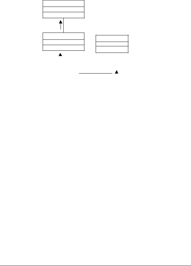
Most important is to realize that the individual apartments, the areas of exclusive use, cannot be found on the cadastral map (see figure 5). The Public Registers have to be queried to find the plan of division. Another disadvantage of this way of registration is that the plans in the notarial deed are drawn in a local coordinate system (in 2D layers). When coordinates were defined in the national reference system they could be combined with the cadastral map or other geo-data (e.g. topographic data). However, the addition of 3D information on the individual apartments in the cadastral system itself would especially enhance insight.
Figure 5: The cadastral map of the apartment complex in figure 3.
The concerning parcel is indicated. The front of the building is indicated with an arrow. Note that the parcel is larger than the footprint of the building.
© UDMS 2002 |
I.7 |

Session I |
The Third Dimension |
NEED FOR A 3D CADASTRAL REGISTRATION
These two cases illustrate the main problem that arises with 3D situations in urban areas in the current cadastral registration: that spatial information in the vertical dimension is unavailable. The Public Registers need to be consulted to get insight in the actual 3D situation in the case of apartment rights. For other cases (e.g. horizontal division of ownership by establishing a right of superficies) adding plans to deeds is voluntary, so consulting the Public Registers does not necessary yield significantly more information.
DESCRIPTION OF A PROTOTYPE OF A 3D CADASTRE
Before we came to a feasible approach for a 3D cadastre for the medium-term feature we started with the concepts of three possible alternative solutions (Stoter et al., 2002):
-Full 3D cadastre, in which 3D parcels and hence 3D rights are supported;
-Hybrid solution, which means preservation of the 2D cadastre and the registration of the situation in 3D within the 2D cadastral registration when this is required from a legal point of view;
-2D classical registration with references, which means preservation of the 2D cadastre with external references to representations of 3D situations (which is current practice).
In Stoter et al. (2002) we concluded that a hybrid approach for a 3D cadastre offers the best possibilities to meet the complications sketched above, both from a legal and technical point of view.
The hybrid approach consists of a registration of the 3D situation in addition to the existing 2D parcel registration. This concept of a 3D cadastre is translated into prototype implementations in the geo-DBMS. For the implementation we use Oracle Spatial 9i. The prototype has been implemented in two ways: using spatial data types and using a topological model. For technical details of the implementation see (Stoter and Van Oosterom, 2002).
For the registration of 2D parcels and 3D situations in one system, we start with a relative simple solution: an extension of the current cadastral registration system, which implies the registration of rights concerning 3D situations in 3D. This implementation is seen as a tool to get insight in the 3D aspect of rights (‘visualization of rights in 3D’): it is not an exact representation on which conclusions with juridical consequences can be drawn.
The registration of 3D right-objects
A 3D right-object is a 3D representation of a right that is established on a 2D parcel and concerns a 3D situation, for example a right of superficies that is limited in the third dimension. The boundary of this 3D representation starts with the parcel boundary and is extended into 3D by means of defining the upper and lower limits. When more detail is required, e.g. in case only a part of a parcel deals with a complex situation, a new (2D) parcel boundary needs to be generated.
The 3D right-objects that are maintained are associated with a registered right and contain a reference to the whole spatial object (physical objects). Spatial and non-spatial characteristics of these physical objects might also be maintained in the DBMS. All 3D right-objects belonging to one 3D physical object can be derived, because they all refer to the same 3D physical object. The registration of a 3D physical object consists of several rights belonging to this particular 3D physical object (right of superficies, condominium right etc). In this way a physical object, e.g. a tunnel, is subdivided into parts according to the ground parcels.
© UDMS 2002 |
I.8 |

Session I |
The Third Dimension |
It can be queried which parcels contain a right or limited right related to a specific 3D physical object. To identify this, a record with at least the identification (the id) of this 3D physical object has to be present within the system. This query cannot be performed in the current cadastral system, as there are no physical objects available. Neither can the 3D extent of a right be queried at the moment (to what height or depth extends the right of superficies?). A 3D right-object associated with a right on a parcel is only registered, when this is juridically required. That is in the case a limited real right is established. In other cases it is voluntary. For that reason it is possible that the 3D physical object is not completely known in the cadastral registration system. This can be illustrated by the example of a railway tunnel. This tunnel is built in the underground of six parcels. The owner of the tunnel (the company “T”) is also the owner of two of these parcels. The other four parcels are owned by respectively A, B, C and D. For each of these parcels a right of superficies is established. In this case the 3D physical object is registered for four surface parcels. Not necessarily for the two parcels owned by T. Therefore the uniformity of the registrations of 3D physical objects and with this insight in the 3D situation can run a risk.
The registration of 3D physical objects
A more advanced solution would also include the registering of 3D physical objects apart from (in addition to) 2D parcels. However, this solution requires considerable adjustments of the current cadastral registration system, technically as well as juridically. A registration of 3D physical objects needs to be organised and maintained and this registration could become a cadastral task. For the implementation of this registration a finite list of objects that need to be registered has to be made. It has to be decided whether this list can include ‘empty space’ objects or not. For this it is interesting to look to similar international experiences: ‘air space parcels’ are known in British Columbia (Gerremo and Hansson, 1998) while ‘construction properties’ in Norway (Onsrud, 2001) and ‘3D property units’ in Sweden (Julstad and Ericsson, 2001) have to consist of actually built constructions. The last two will get legal force in the coming years. When 3D physical objects (as they are defined on the finite list) are realised, they have to be registered. To make the registration indisputable, a law is needed to make the registration compulsory. From a technical point of view 3D physical objects are more difficult to maintain since the geometry of physical objects is more complex than the geometry of 3D right-objects (generating data, implementing data structures and spatial analyses are more complex).
When 3D physical objects are maintained, a 3D physical object can be queried (spatially and administratively) as a whole (e.g. which parcels are intersecting with (the projection of) a 3D physical object?; which rights are established on these parcels; who are the right-owners?).
Prototype implementation
In this research we are looking for a feasible solution in the medium-term future. Therefore we first focus on the registration of rights in 3D (3D right-objects). Figure 6 depicts the needed extension of the current cadastral data model in UML (Warmer and Kleppe, 1998).
To describe the rights concerning complex situations in 3D we introduce a table (3D righttable) that contains for every parcel the different height-levels of ownership (z-list). The z-list contains n z-values corresponding to n-1 consecutive ranges associated with the parcel. Redundancy is avoided since only the z-levels are stored in addition to the currently stored data (boundary of parcels). This information is sufficient to generate the representation of 3D right-objects based on the geometry of parcel boundaries. The 3D right-objects are identified by unique numbers that are based on the concerning parcel number.
© UDMS 2002 |
I.9 |
Session I |
The Third Dimension |
Holders of a 3D right-object can be obtained by the right to which the 3D right-object is associated (e.g. a right of superficies). The right-owner of this right (subject) is the holder of the 3D right-object. For this moment the height-levels are invariant for every 3D right-object, which means that the upper and lower boundaries of 3D right-objects are defined by horizontal planes.
3D Physical Object
1
has a reference to
1..*
3D Right Object |
Object |
|
is associated with |
|
* |
|
|
1..* |
|
||
|
|
|
||||||
|
|
|
|
|||||
|
1 |
|
|
|
||||
|
|
|
1 |
|
|
|
|
|
|
Right |
|
|
has a right on |
||||
|
|
|
|
|
|
|||
|
|
|
|
|
|
|
|
|
|
|
|
|
|
|
|
|
|
|
|
|
|
|
|
|
|
|
|
|
|
|
|
|
1..* |
|
|
|
|
|
|
|
|
|
||
|
|
|
|
|
Subject |
|
||
|
|
|
|
|
|
|
|
|
|
|
|
|
|
|
|
|
|
|
|
|
|
|
|
|
|
|
Figure 6: UML class diagram for the cadastral data model including the registration of 3D right-objects: An object is a parcel or a condominium right and a subject is a person who has a right on an object.
PROTOTYPE APPLIED TO CASES
Case “Den Haag Centraal”
For the building complex “Den Haag Centraal” the 3D right-table looks as follows:
PARCEL |
Z_LIST |
------ |
-------------- |
12131 |
Z_ARRAY(0, 12, 40) |
13290 |
Z_ARRAY(0, 12) |
13288 |
Z_ARRAY(0, 12) |
13289 |
Z_ARRAY(0, 12) |
13294 |
Z_ARRAY(0, 3, 12) |
13291 |
Z_ARRAY(0, 3, 12) |
13293 |
Z_ARRAY(0, 3, 12) |
13292 |
Z_ARRAY(0, 3, 12) |
13295 |
Z_ARRAY(0, 6, 12) |
For every parcel a z-list is stored, that defines the upper and lower limits of rights established on the parcel. For example, the vertical extents of the rights on the parcel that contains the tram and bus station and the railway platform (parcel ‘13295’), are as follows:
-railway platform (owned by “NS Vastgoed”): 0 to 6 m
-tram/bus station (right of superficies, holder Municipality of Den Haag): 6m to 12 m.
© UDMS 2002 |
I.10 |