

Экзамен зачет учебный год 2023 / Stoter, Ploeger, Multiple Use of Space. Current practice of Registration and Development of a 3d Cadastre
.pdfSession I |
The Third Dimension |
While in this case the notarial deed gives no information about the boundaries of the established right of superficies in the third dimension, the levels were obtained by measuring the building ourselves.
The legal status of the space above and under the building complex is not explicitly registered. However according to the legal rule the owner of the parcel is owner of the space under the complex and the subject who has a right of superficies on the parcel is owner of the space above the construction. In this case the limits of the 3D right-objects are related to the construction as built. If the limits of the rights are defined in the deeds these can be used to construct the 3D right-objects. In that case it can happen that the visualization of the 3D rightobjects is different than the actual built construction (e.g. when a right of superficies exceeds the actual construction).
The visualization of the generated 3D right-objects is shown in figure 7.
Figure 7: Visualization of 3D right-objects that were generated in the DBMS (“Den Haag Centraal”).
This visualization gives a clear insight of the various rights in the building complex. Not only it gives an indication of the spatial component of the property rights on each of the concerned parcels, it also shows the relation between the rights established on adjacent parcels. The 3D map of Den Haag Centraal clearly shows that the Municipality of Den Haag is not only holding the right of superficies on parcel 13295 (the big parcel in the center, with the railway platforms on ground level), but also of the parcels 13291, 13292, 13293 and 13294. At a glance one can see that the Municipality is owner of the bus/tram station on the second floor, with the adjacent entrances at left and right hand side of the railway station. This is a great advantage compared to the traditional 2D cadastral map.
However it must be noticed that the 3D map only shows the 3D right-objects and not the physical object (in this case the whole complex) itself. The physical object is only used to determine and visualize the vertical limits of the right of the landowner and the limited real rights. Also it is important to notice that it is possible that a part of the structure is not visualized because it is in full ownership with the owner of the land. In the previous section
© UDMS 2002 |
I.11 |
Session I |
The Third Dimension |
we illustrated this by the example of a railway tunnel. In figure 7 this is the case with parcel 12677: the small parcel just in front of the railway platforms and bus station. In fact the railway platforms are also erected on this parcel. However this part of the complex is not visualized because “NS Railinfratrust BV” holds it in full ownership. Generally speaking, every part of a complex that is erected on a parcel that is in full ownership will not be shown on the 3D map.
Apartment building
The case of the apartment building is more complicated, since on the first floor there we find three apartment owners and on the second and third floor two owners, all established on one parcel. Furthermore not the whole parcel is covered with the building. This is quite common for apartment complexes.
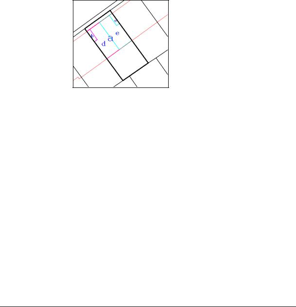
To be able to apply the z-list introduced earlier, the 2D boundaries of the properties (individual apartments) are generated, which gives the 2D objects as shown in figure 8, with object a (whole building minus b and c), b and c defined for the first floor and object d and e (both half of the building) defined for the second and third floor.
Figure 8: The generated 2D objects: footprints of individual apartments on every floor.
The 3D right-table for the whole apartment complex looks as follows:
PARCEL Z_LIST
------ ----
6408_a Z_ARRAY(0,3)
6408_b Z_ARRAY(0,3)
6408_c Z_ARRAY(0,3)
6408_d Z_ARRAY(3, 6, 10)
6408_e Z_ARRAY(3, 6, 10)
Note that these are not parcel numbers but objects generated to define the inner boundaries of the apartments in order to extract them in 3D. This case shows two complications. First not only a horizontal division is needed to define the 3D right-objects but also a vertical division (dividing the parcel in smaller parts). This is obviously required when defining these 3D right-objects but the generation of the smaller parts is a big change in the concept if they get a legal status. Second there is overlap in the 3D right-objects when projecting them on the surface, which means that there is not a 2D parcel defining the 2D boundaries of the 3D rightobjects. These two drawbacks could be solved when a full 3D approach would be used.
The visualization of the generated 3D right-objects is shown in figure 9.
© UDMS 2002 |
I.12 |
Session I |
|
The Third Dimension |
||
|
|
|
|
|
|
|
|
|
|
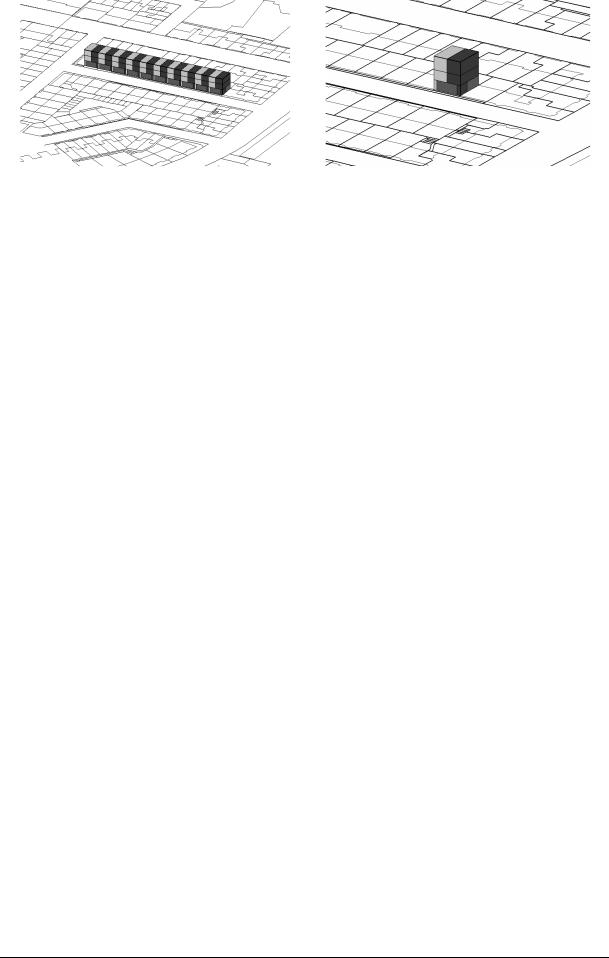
Figure 9: Visualization of 3D right-objects (apartment rights) that were generated in the DBMS (left all apartments in the street and right the apartment complex of the case study which is the second complex from right).
CONCLUSION
The objective of every cadastral registration system is to give insight in rights on land. In this paper we analyzed two cases of multiple use of space: a building complex and a small apartment complex. We found that the use of 2D parcels as the only basis for registration has important limitations. The main problem is that the cadastral registration system cannot reflect the vertical component of ownership rights and real limited rights concerning complex situations.
In our research to find a solution we introduced 3D right-objects. These 3D representations of rights improve insight in spatially complex situation considerably, as was illustrated by applying this solution to the described cases. The 3D right-object starts with the 2D parcel boundary on which the right is established. This is extended into 3D by means of defining upper and lower limits of the right. This approach yielded some complications in case of the apartment complex, which have to be studied further.
In conclusion, inserting 3D right-objects on the cadastral map gives an overview of the horizontal division of ownership, which is a significant enhancement of the current system. Incorporation of 3D right-objects in the cadastral registration system provides information on the vertical component of rights without having to consult the Public Registers. Furthermore, since references are maintained to the whole spatial object, all parcels can be found that are intersecting with one particular physical object (e.g. a tunnel). On the other hand, a drawback of the proposed prototype is that such objects above or below several 2D parcels have to be subdivided in as many 3D right-objects as there are parcels on the surface.
Based on the experiences in the case studies, the concept of a 3D cadastre as well as the prototype implementations will be improved to come to an optimal solution. Future research will also focus on spatially defining 3D right-objects more precisely (topologically and geometrically), as well as on the study if the approach of 3D right-objects suffices or a more advanced solution is required: the registration of 3D physical objects (as they occur in reality). This will require more drastic changes in the current cadastral registration system.
ACKNOWLEDGEMENTS
We would like to thank the Netherlands’ Kadaster for their support and for using their data during this research. We are grateful to Oracle and Bentley for using their software and for their support. Finally we would like to thank professor Peter van Oosterom and Elfriede M. Fendel for their review on earlier versions of this paper and for their suggestions for improvements
© UDMS 2002 |
I.13 |

Session I The Third Dimension
REFERENCES
Civil Code (Burgerlijk Wetboek) (1992): Boek 5: Zakelijke Rechten, 1992. (In Dutch)
Gerremo J. and J. Hannson (1998): Ownership and real property in British Colombia: a legal study, MSc thesis (nr. 48), Royal Institute of Technology, Stockholm, Department of Real Estate and Construction Management, Division of Real Estate Planning and Land Law.
Julstad, B. and A. Ericsson (2001): property formation and three-dimensional property units in Sweden, Proceedings of the international workshop on 3D-Cadastres - registration of properties in strata, pp.173-190, Delft, November 28-30, FIG, Frederiksberg, Denmark. ISBN 87-90907- 15-9.
Kleyn, D.G. and A. Borraine (1992): The Law of Property, 3rd edition, Butterworths, Durban, 1992. ISBN 0-409-05314-7.
Lemmen, C.H.J., E.P. Oosterbroek and P.M.J. van Oosterom (1998): New spatial data management developments in the Netherlands Cadastre, FIG XXI International Congress, Brighton UK, Commission 3, Land Information Systems, pp. 398-409, 19-25 July 1998.
Nieper, F and H.D. Ploeger (1999): Sachenrecht in Europa, Niederlande (Christian von Bar, ed.), Universitätsverlag Rash, Osnabrück 1999. ISBN 3-934005-31-4.
Onsrud, H. (2001): Making laws for 3D cadastre in Norway. Proceedings of the international workshop on 3D-Cadastres - registration of properties in strata, pp.191-199, Delft, November 28-30, FIG, Frederiksberg, Denmark. ISBN 87-90907-15-9.
Oosterom, P.J.M. van and C.H.J. Lemmen (2001): Spatial data management on a very large cadastral database, Computers, Environments and Urban Systems (CEUS), volume 25, number 4-5, pp. 509-528.
Oosterom,. P.J.M. van, J.E. Stoter, S. Zlatanova, W.C. Quak (2002): The balance between Geometry and Topology, Spatial Data Handling 2002 Symposium, Ottowa, Canada, 9-12 July 2002.
Stoter, J.E. (2000): Needs, possibilities and constraints to develop a 3D cadastral registration system, UDMS 2000, Delft, the Netherlands, 11-15 September 2000.
Stoter, J.E., M.A. Salzmann, P.J.M. van Oosterom and P. van der Molen (2002): Towards a 3D Cadastre, FIG XXII/ACSM-ASPRS, 19 – 26 April, 2002, Washington, USA.
Stoter, J.E., and P.J.M. van Oosterom (2002): 3D data modelling in a geo-DBMS, GIScience 2002, Boulder, Colorado, 25-28 September, 2002, USA.
Snijders, H.J. and E.B. Rank-Berenschot (2001): Goederenrecht, 3rd edition, Kluwer, Deventer 2001. ISBN 90-268-3446-2. (in Dutch).
Van Velten, A.A. and T.M. Aldridge (1996): Copropriété and commonhold, Apartment ownership in the European Union, Union Internationale du Notariat Latin, Amsterdam 1996.
J. Warmer and A. Kleppe (1998) The Object Constraint Language: Precise Modeling with UML, Addison-Wesley, 1998.
© UDMS 2002 |
I.14 |

Session I |
The Third Dimension |
CV OF THE AUTHORS
Jantien Stoter (MSc) graduated in Physical Geography in 1994. She started her career as a GIS specialist/consultant, with the District Water Board of Amsterdam and Surroundings (1995-1997). From 1997 till 1999 she worked as a GIS specialist/consultant at the Engineering Office Holland Rail Consult. Since 1999 she is an assistant professor in GIS applications, section GIS technology, Department of Geodesy, Delft University of Technology. Also doing a PhD on 3D cadastres. In this research the needs, possibilities, and constraints are studied for 3D cadastral registrations. The emphasis of the research is the implementation of the facility to incorporate 3D real estate objects (geo-objects) in the current 2D geo-DBMS of the Netherlands’ Kadaster.
Dr. Hendrik Ploeger studied Dutch Law at Leiden University and Notary Law at the Free University of Amsterdam. In 1997 he finished his thesis on the subject of the horizontal division of ownership (Horizontale splitsing van eigendom, Leiden 1997). At the E.M. Meijers-Institute of Legal Studies he did research on the rights of land owners and the building of drilled tunnels (publication: Civielrechtelijke aspecten van de aanleg van boortunnels, Kluwer 1997). From 1997 until 2001 he was assistant professor in Civil and Notary Law, Department of Civil Law, Leiden University. He is now assistant-professor at the Delft University of Technology, Department of Geodesy, section Geoinformation and Land Development
CO-ORDINATES
J.E. Stoter and H.D. Ploeger Department of Geodesy
Faculty of Civil Engineering and Geosciences Delft University of Technology
P.O. Box 5030
2600 GA Delft
The Netherlands
Tel. +31-15-2788136/2782557 Fax +31-15-2782745
E-mail j.e.stoter@citg.tudelft.nl h.d.ploeger@citg.tudelft.nl
Website www.geo.tudelft.nl
© UDMS 2002 |
I.15 |

Session I |
The Third Dimension |
© UDMS 2002 |
I.16 |