

Учебное пособие 2131
.pdfIssue № 1(33), 2017 |
|
|
|
|
ISSN 2542-0526 |
||
|
|
|
|
|
|
End of Table |
|
1 |
2 |
3 |
4 |
5 |
6 |
7 |
|
Wales – 22 ATUs |
20.7 |
1 |
5.0 (24 %) |
3.0 |
0.7 (25 %) |
144 |
|
11 ATUs |
|
South Wales |
5.0 |
|
0.7 |
140 |
|
Scotland –– 32 |
78.0 |
4 |
4.4 (6 %) |
5.3 |
0.5 (10 %) |
68 |
|
ATUs |
|||||||
|
|
|
|
|
|
||
1county: Fife–– |
1.3 |
1 |
0.5 (38 %) |
0.36 |
0.05 (13 %) |
272 |
|
1 ATU |
|||||||
|
|
|
|
|
|
||
1 ATU |
|
Fife |
0.5 |
|
0.05 |
100 |
|
GERMANY |
357.0 |
13 |
9.3 (2.6 %) |
81.2 |
no data |
227 |
|
North Rhine- |
|
|
|
|
|
|
|
Westphalia –– |
|
|
|
|
|
|
|
5 ATUs at the re- |
|
|
|
|
|
|
|
gional level: Düs- |
34.1 |
2 |
8 (23 %) |
17.5 |
5.0 (15 %) |
513 |
|
seldorf, Münster, |
|
|
|
|
|
|
|
Arnsberg, Co- |
|
|
|
|
|
|
|
logne, Detmold |
|
|
|
|
|
|
|
25 ATUs at the |
4.4 |
Rhine-Westphalia |
7.2 |
|
5.0 |
694 |
|
local level |
(Ruhr) |
|
|||||
|
|
|
|
|
|||
Saarland –– 6 |
|
|
|
|
|
|
|
ATUs at the local |
2.5 |
1 |
1.2 (50 %) |
1.0 |
0.7 (70 %) |
389 |
|
level |
|
|
|
|
|
|
|
6 ATUs at the |
|
Saar |
1.2 |
|
0.7 |
580 |
|
local level |
|
|
|||||
|
|
|
|
|
|
||
FRANCE |
547.0 |
2 |
0.5 (0 %) |
64.0 |
6 (9 %) |
116 |
|
1department: |
|
|
|
|
|
|
|
Alsace, |
|
|
|
|
|
|
|
Champagne- |
57.4 |
1 |
0.3 (0.5 %) |
5.5 |
2.3 (42 %) |
97 |
|
Ardenne, Lorraine |
|
|
|
|
|
|
|
––10 ATUs |
|
|
|
|
|
|
|
4 ATU |
23.5 |
Lorraine (part of |
0.3 |
3.3 |
2.3 |
140 |
|
the Saar region) |
|||||||
|
|
|
|
|
|
||
POLAND |
312.6 |
1 |
5.5 (2 %) |
37.9 |
4.8 (13 %) |
124 |
|
3 voivodeships: |
|
|
|
|
|
|
|
Silesia –– 36 |
|
|
|
|
|
|
|
ATUs, Lesser –– |
|
|
|
|
|
|
|
22 ATUs, |
36.9 |
1 |
5.5 (15 %) |
8.9 |
4.8 (54 %) |
392 |
|
|
|||||||
Opole –– 12 ATUs, including in total 70 ATUs at the local level
81

|
Russian journal of building construction and architecture |
|
|
||||
|
|
|
|
|
|
End of Table |
|
1 |
2 |
3 |
4 |
5 |
6 |
7 |
|
34 ATUs at the |
|
Górnośląskie or |
|
|
|
|
|
|
Ostrava-Karviná |
5.5 |
|
4.8 |
872 |
||
local level |
|
|
|||||
|
(Katowice) |
|
|
|
|
||
|
|
|
|
|
|
||
CZECH |
78.8 |
5 |
no data |
10.5 |
no data |
133 |
|
REPUBLIC |
|||||||
|
|
|
|
|
|
||
Moravskoslezský |
5.4 |
|
0.95 (18 %) |
1.2 |
0.5 (42 %) |
222 |
|
kraj –– 6 АТUs |
|
||||||
|
|
|
|
|
|
||
|
|
Górnośląskie or |
|
|
|
|
|
no data |
|
Ostrava-Karviná |
0.95 |
|
0.5 |
526 |
|
|
|
(Ostrava) |
|
|
|
|
|
UKRAINE |
576.6 |
2 |
50 (9 %) |
42.5 |
3.8 (9 %) |
73 |
|
|
|||||||
2 oblasts: Donetsk |
|
|
|
|
|
|
|
–– 18 ATUs, Lu- |
53.1 |
1 |
10 (19 %) |
6.4 |
2.6 (40 %) |
120 |
|
gansk ––18 ATUs |
|
|
|
|
|
|
|
no data |
|
Donbass |
10.0 |
|
2.6 |
260 |
|
|
(Western part) |
|
|||||
|
|
|
|
|
|
||
RUSSIA |
17125.1 |
27 |
about 2500 |
146.5 |
3.5 (2 %) |
8 |
|
(15 %) |
|||||||
|
|
|
|
|
|
||
Rostov region –– |
100.0 |
1 |
13 (13 %) |
4.2 |
0.6 (14 %) |
42 |
|
55 ATUs |
|||||||
|
|
|
|
|
|
||
8 ATUs |
|
Donbass |
13.0 |
|
0.6 |
46 |
|
|
(Eastern part) |
|
|||||
|
|
|
|
|
|
||
Kemerovo region |
95.5 |
2 |
26.7 (28 %) |
2.7 |
2 (74 %) |
28 |
|
–– 39 ATUs |
|||||||
|
|
|
|
|
|
||
24 ATUs |
|
Kuzbass |
26.7 |
|
2 |
74 |
|
|
|
|
|
||||
3. Comparative analysis of old industrial coal mining regions in Europe and Russia. The comparative statistical and cartographic studies of the selected old industrial coal regions where coal has been mined for more than 150 years, has resulted in establishing that:
1. In European old industrial coal regions: Yorkshire, Wales, Fife (United Kingdom), Ruhr (Germany), Saarland (parts of the coal basin in Germany and France), Górnośląski (parts of the coal basin in Poland and the Czech Republic), Donbass (parts of the coal basin in Ukraine and Russia), Kuzbass (Russia), the value of population density per 1 sq. m. corresponds to the mean country value (or its major part within the established boundaries of ATUs), and in most cases is higher than this value.
82
Issue № 1(33), 2017 |
ISSN 2542-0526 |
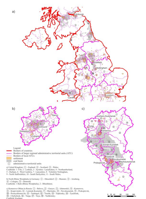
Fig. The current urban development situation in old-developed coalfields in Europe and Russia: а) the territory of coalfields in the United Kingdom, b) the territory of coalfields basins in North Rhine Westphalia, Germany, c) the territory of coalfields in the Kemerovo region of Russia
83

Russian journal of building construction and architecture
The average value of the density of population per 1 sq. km in the UK is 266 (Yorkshire –– 384, Fife –– 272), in the large part of the United Kingdom –– Wales is 144 (South Wales –– 140); in Germany the value is 227, in its major parts of the Land of North Rhine-Westphalia is 513 (Ruhr –– 694), in Saarland is 389 (Saarland –– 580); in France this value is 116 (French part of the Saar coal basin –– Lorraine –– 140); in Poland this indicator is 124 (Górnośląski –– 392); in the Czech Republic this value equals 133 (Górnośląski –– 526); in Ukraine this figure is 73 (Donbass –– 260).
2.In Russia in old industrial coal regions –– Donbass (a part of the coal basin in territory Rostov Oblast), Kuzbass –– the value of population density per1 sq. m is higher than the average for the country (or its large part within the established boundaries of ATUs).
The average value of the density in Russia is 8 thousand people per 1 square km, and in the coal basins of Donbass and Kuzbass the values of this index is 46 and 74 respectively.
3.In European old industrial coal regions: Yorkshire, Wales, Fife (United Kingdom), Ruhr (Germany), Saarland (parts of the coal basin in Germany and France), Górnośląski (parts of the coal basin in Poland and the Czech Republic), Donbass (parts of the coal basin in Ukraine and Russia), Kuzbass (Russia), despite the location of coalfields within several ATUs of different management levels, the population densityis higher than this value for non-coal regions.
4.Despite the fact that the share of coal districts in the total area of the countries (their major parts in ATUs), is not more than a quarter of the territory, the proportion of the population located in these areas in European countries is not smaller than the share of the area of such coal regions in the country. In particular: in the UK the coal mining area is 8 % and the population portion in this region is 9 %, respectively; in Germany this figure is 3 % (more than 15 %); in Poland –– this value is 2 % (13 %) in Ukraine this indicator equals 9 % (9 %) (Note 6).
5.The proportion of coal districts in the total area of Russia is not more than 15 % of the territory, and the proportion of the population located in the main coal mining regions is about 2 %. Moreover, in relation to large parts within the borders of administrative territorial units of the regional level, the proportion of Donbass in Rostov Oblast is 13 %, and the proportion of the population located in the of coal mining area is 14 % of the total oblast population; the share of Kuzbass in Kemerovo Oblast 28 % and 74 %, respectively.
Importance of the obtained results
The results of mapping and statistical analysis show that there is uncertainty due to the influence of environmental, geological and economic processes in the consideration of various old industrial coal mining areas, as well as the proposed analytical tools. None of the models is actually a complete representation of reality. However, there are objective evidence-based
84

Issue № 1(33), 2017 |
ISSN 2542-0526 |
patterns of development of old industrial coal areas located in major coalfields which do not disappear without trace, are not massively converted in the "ghost towns", and acquire new urban more complex forms.
Patterns and relationships, reflecting the current town planning situation are determined by the population density, the concentration of settlements and the ratio of the coal mining land area and the total area of the country and its large parts within the boundaries of administra- tive-territorial units. This is confirmed by scientists: "the vital settlement factors are the long rivers by which you can judge the geodynamics of active areas of the Earth's surface (to which mineral deposit zones belong)" [5], as well as "about 1/3 of all the cities of the world emerged on the basis of certain natural resources"[9].
The proposed cartographic analysis of the current urban situation in the first phase of the urban development project at interregional and international levels for the coal mining areas provides urban planners and researchers with another example of the use of GIS technologies, expanding the range of the previously known theoretical and practical studies with the use of GIS, e.g., to link remote sensing and regional census data, to use multiscale spatial and statistical analysis to assess the impact of re-developed areas on adjacent residential property [55]. Knowledge and timely assessment of the urban development potential taking into account the specific conditions and characteristics of land use will be useful for the old industrial, existing and new (potential) areas of coal mining around the world. Use of the urban development potential of the coal mining areas is important for Russia which does not have a high population density. Within the country it is advisable to overcome the centripetal direction of the Moscow megalopolis development with shrinking of the rest of the country's urban space.
The results can be used to improve energy sustainable policies and to deal with redevelopment of the territories disturbed by coal mining activities in various countries around the world that have minerals (coal), at other, previously non-applicable, inter-regional and international levels of urban planning of coal mining areas.
The proposed comparative analysis allows to investigate into similar phenomena for the lignite coal mining areas, to which Mosbass and Kizelbass belong in the territory of Russia, coal mining in which is fully completed.
Research in this direction with the use of modern information technology tools with the inclusion of a greater number of indicators and data can be continued.
Conclusions
The results of the comparative analysis evidences regularities of statistical relative indicators. The spatial arrangement of European and Russian old industrial coal mining areas, deter-
85

Russian journal of building construction and architecture
mined by the high concentration of settlements, characterizes a significant urban development potential of their areas.
There is an urban development potential of such areas both for the coal mining period and after its completion, despite the fact that the territories disturbed as a result of coal mining are formed in the coal mining areas. The territories are provided with infrastructure in the existing settlement system after the full exhaustion of commercial coal reserves (in the UK) and in case of incomplete exhaustion due to changes in the technical and economic coal needs (in Germany).
The proposed statistical analysis is quite simple, because it uses publicly available data, knowledge of which is necessary and sufficient for the initial stage of preparation of an urban development project.
Notes
Note 1. The list of the basic scientific research [electronic resource] // RAASN: [web-site] [2015]. URL: http://www.raasn.ru/contests/6_1.pdf (reference data: 01.07.2016)
Note 2. The coal mining area is the territory where direct coal mining activities are carried out in the form of: mine preparation works, coal mining, enrichment and processing of coal and its by-products к land reclamation and associated livelihoods of people, including the use of various material facilities, including residential, sociocultural and communal, engineering and transport infrastructure [2].
Note 3. Prospective Russia's largest coal basins: Tunguska, Lena, Taimyr, Zyriansky, South Yakutia, Irkutsk. Note 4. Rosstat [Electronic resource] [web-site] [2016] URL: http://www.gks.ru/ (reference data: 01.03.2016) Note 5. Non-commercial web mapping site map of the world [Electronic resource] // OpenStreetMap: [web-site] [2016] URL: http://openstreetmap.ru (reference date: 01.03.2016)
Note 6. For France and the Czech Republic, in the territory of which insignificant parts of old developed coal mining areas of the Saar and Górnośląski are located, the most parts of which are located within the modern borders of Germany and Poland, respectively, due to the lack of complete and reliable data, quantitative information about the fractions of the area of the coal basin in the country's total area and share of population of the coal mining areas in the total population of the country is not given.
Note to the table. Donbass coal basin area is about 60 square kilometers. For calculations Table 1 uses the value of 23 square kilometers –– an area of the old developed part of Donbass, including in Russia –– 13 square kilometers, in the Ukraine –– 10 square kilometers.
References
1.Alekseev Yu. V., Samoylova N. A. The approach to organizing the city planning and forming the urban coal-mining area border. Architecture and building in Russia, 2015, no. 8, pp. 30––39.
2.Belokon Iu. N. Regional planning (theory and practice). Kyiv, Logos Publ., 2003. 259 p.
86

Issue № 1(33), 2017 |
ISSN 2542-0526 |
3.Gorkina T. I. The world's coal industry. The regional aspects of the development. ID "First of September" [Electronic resource]. Journal "Geography", 2009, no. 18. Available at: http://geo.1september.ru/articles/2009/18/06 (accessed 01.12.2014).
4.Koniukhov D. S. Underground spapce use. Moscow, Arkhitektura-С Publ., 2004. 296 p.
5.Lazareva I. V. URBI ET ORBI: The fifth dimension of the city. Theoretical urban development grounds. Moscow, LENAND Publ., 2006. 80 p.
6.Lazareva I. V. The history of practical and scientific works for reclamation of disturbed areas –– the way of Russian innovations. Collection of materials of the International Scientific Conference (June 10––15, 2013, Novosibirsk –– Novokuznetsk , 2013). Natural-technological complexes: reclamation and sustainable functioning. Novosibirsk, Publishing House Okarina, 2013, pp. 24––27.
7.Liubovyi V. Ya. Problems of regulation of development of cities and city agglomerations under the coal industry restructuring conditions (foreign and domestic experience). Moscow, Publishing House "Ekon-Inform", 2015. 168 p.
8.Nayfeld L. P. The development of inconvenient lands for urban planning. Translated from English. Moscow, Stroiizdat Publ., 1968. 224 p.
9.Pertsik E. N. Geography of cities (geo-urbanistics). Moscow, Vysshaia Shkola Publ., 1991. 319 p.
10.Pinde Fu. Web GIS: Principles and Applications. Translated from Chinese, translated from English –– Esri Press, USA, Redlands, California, 2013. 356 p.
11.Popov А. А. Rise and fall os "Silesian eldorado": the role of the coal industry in the history of Poland in the second half of the twentieth century. Scientific Bulletin of the Chelyabinsk State University, 2015, no. 24 (379), iss. 66. pp. 168––172.
12.Wallwork K. Disturbed lands. Translated from English. Moscow, Progress Publ., 1979. 269 p.
13.Hall P. Urban and regional planning. Translated from English. Moscow, Stroiizdat Publ., 1993. 247 p.
14.Alexandrescu F., Bleicher A., Weiss V. Transdisciplinarity in practice: The emergence and resolution of dissonances in collaborative research on brownfield regeneration. Interdisciplinary Science, 2014, no. 39 (4), pp. 307––322.
15.Alexandrescu F., Martinát S., Klusáček P., Bartke S. The Path From Passivity Toward Entrepreneurship: Public Sector Actors in Brownfield Regeneration Processes in Central and Eastern Europe. Organization and Environment, 2014, no. 27 (2), pp. 181––201.
16.Bartke S., Schwarze R. No perfect tools: Trade-offs of sustainability principles and user requirements in designing support tools for land-use decisions between greenfields and brownfields. Journal of Environmental Management, 2015, no. 153, pp. 11––24.
17.Bastida F., Guillamón M., Benito B. Municipal Spending in Spain: Spatial Approach. Journal of Urban Planning and Development, 2013, no. 10.1061(ASCE), pр. 79––93.
18.Burke H., Hough E., Morgan D. J. R., Hughes L., Lawrence D. J. Approaches to inform redevelopment of brownfield sites: An example from the Leeds area of the West Yorkshire coalfield, UK. Land Use Policy, 2015, vol. 47, pр. 321––331.
19.Cała M., Ostrȩga A. Geotechnical aspects of revitalisation of post-mining areas - An example of the adaptation of katowice hard coal mine for the new silesian museum. Archives of Mining Sciences, 2013, vol. 58, iss. 2, pр. 361––374.
87

Russian journal of building construction and architecture
20.Chang Y.-Z., Dong S.-C. Evaluation of Sustainable Development of Resources-Based Cities in Shanxi Province Based on Unascertained Measure. Sustainability, 2016, no. 8, 585, pр. 1––18.
21.Chapman G. R., Highley D. E ., Camelot D. G., Norton G. E., Taylorand L. E., Lusty P. A. Summary of information on coal for land-use planning purposes. Commissoned Report CR/06/114N British Geological Survey Natural Enveronment research concil Departament for Communitees and Local Go vernment. Nottingham British Geological Survey, 2006, 35 p. Coal Mine Methane Country Profiles, June 2015. "U. S. Environmental Protection Agency, Coalbed Methane Outreach Program (CMOP)" In support of the Glo bal Methane Initiative. Available at: https://www3.epa.gov/cmop/international/cmm-country-profiles.html
22.Colantonio A., Dixon T. Urban Regeneration & Social Sustainability: Best Practice from European Cities. Wiley-Blackwell, Chichester, 2011. 317 p.
23.Ćopić S., Dordević J., Lukić T., Stojanović V., Dukičin S., Besermenji S., Stamenković I., Tumarić A. Transformation of industrial heritage –– an example of tourism industry development in the Ruhr area (Germany). Geographica Pannonica, 2014, vol. 18, iss. 2, pp. 43––50.
24. Danel R., Neustupa Z., Stalm achová B. Best practices in design of database of Brownfield revitalization projects. 12th International Multidisciplinary Scientific GeoConference and EXPO –– Modern Management of Mine Producing, Geology and Environmental Protection, 17 June 2012 through 23 June 2012, SGEM 2012. Varna, Bulgari, 2012, no. 3, pp. 49––56.
25. Doleželová L., Hadlač M., Kadlecová M., Martinát S., Polednik M. Redevelopment potential of brownfields: A-B-C model and its pracctical application. E & M Ekonomie a Management, 2014, no. 18 (2), pp. 33––44.
26.Frantál B., Greer-Wootten B., Klusáček P., Krejčí T., Kunc J., Martinát S. Exploring spatial patterns of urban brownfields regeneration: The case of Brno, Czech Republic. Cities, 2015, no. 44, pp. 9––18.
27.Frantál B., Kunc J., Klusáček P., Martinát S. Assessing success factors of brownfields regeneration: International and inter-stakeholder perspective. Transylvanian Review of Administrative Sciences, 2015, no. 44, pp. 91––107.
28.Frantál B., Kunc J., Nováková E., Klusáček P., Martinát S., Osman R. Location matters! exploring brownfields regeneration in aspatial context (acase study of the South Moravian Region, Czech Republic). Moravian Geographical Reports, 2013, no. 21 (2), pp. 5––19.
29. Frantál B., Nováková E. A. Сurse of coal? exploring unintended regional consequences of coal energy in the Czech Republic. Moravian Geog raphical Reports, 2014, no. 22 (2), pp. 55––65.
30.Greenhalgh P., Helen H. Developing an Indicator of Property Market Resilience-Inv estigating the Potential of GIS to Analyse Business Occupier Displacement and Property Market Filtering: A Case Study of Tyne and Wear. Urban Studies, 2013, no. 50 (2), pр. 372––390.
31.Kowalska J. I. Challenges for long-term industry restructuring in the Upper Silesian Coal Basin: What has
Polish coal mining achieved and failed from a twenty-year perspective? Resources Policy, 2015, no. 44, pр. 135––149.
32.Kretschmann J. Challenges of the post-mining era in Germany. Eurasian mining, 2015, no. 2, pp. 52––56.
33.Kretschmann J. Stakehloder orientated sustainable land management: The Ruhr Area as a role model for urban areas. Internationale Journal of Mining Science and Technology, 2013, no. 23, pp. 659––663.
88

Issue № 1(33), 2017 |
ISSN 2542-0526 |
34.Kunc J., Klusáček P., Martinát S. Percepce a lokalizace urbánních brownfields: Podobnosti a rozdíly na příkladu Brna a Ostravy. Urbanismus a územní rozvoj, 2011, no. 14 (1), pp. 13––17.
35.Lamich D., Marschalko M., Yilmaz I., Bednářová P., Niemiec D., Kubečka K., Mikulenka V. Subsidence measurements in roads and implementation in land use plan optimisation in areas affected by deep coal mining. Environmental Earth Sciences, 2016, no. 75 (1), pp. 1––11.
36.Leifchild J. R. Our Coal and Coal Pits (Published in the year 1968, Our Coal and Coal Pits is a valuable contribution to the field of Economics). Cass Library of Industrial Classics, 2012, no. 23, pp. 1––243.
37.Limonov L. E., Nesena M. V. Structural and economic typology of large Russian cities. Regional Research of Russia, 2016, no. 6, pp. 144––155.
38.Margalit H. Energy, Cities and Sustainability: An Historical Approach. University of New South Wales, Australia, 2016. 196 p.
39.Marschalko M., Yilmaz I., Bednárik M., Kubečka K., Lahuta H. Relevance of building site categories implementation into the land use plan in undergroundmining area in the region of Petrvald (Czech Republic). Environmental Earth Sciences, 2014, no. 72(9), pр. 3443––3456.
40.Marschalko M., Yilmaz I., Bednárik M., Kubečka K., Bouchal T., Závada J. Subsidence map of underground mining influence for urban planning: An example from the Czech Republic. Quarterly Journal of Engineering Geology and Hydrogeology, 2012, no. 45 (2), pp. 231––241.
41.Marschalko M., Yilmaz I., Lamich D., Drusa M., Kubečková D., Peňaz T., Burkotová T., Sochorková A. Unique documentation, analysis of origin and development of an undrained depression in a subsidence basin
caused by underground coal mining (Kozinec, Czech Republic). Environmental Earth Sciences, 2014, no. 72 (1), pp. 11––20.
42.Martinát S., Dvořák P., Klusáček P., Kunc J., Havlíček M. Hybné síly dlouhodobých proměn industrializované krajiny (případová studie Hrušov). Acta Pruhoniciana, 2014, no. 106 (1), рp. 35––44.
43.Martinát S., Kunc J., Klusáče k P., Krejčí T., Navrátil J., Vnenková J., Černík J. Sp atial relations and perception of brownfields in old industrial region: Case study of Svinov (Ostrava, Czech Republic). Geographia Technica, 2015, no. 10 (2), pp. 66––77.
44.Martinat S., Dvorak P., Frant al B., Klusacek P., Kunc J., Navratil J., Osman R., T ureckova K., Reed M. Sustainable urban development in a city affected by heavy industry and mining? Case study of brownfields in Karvina, Czech Republic. Journal of Cleaner Production, 2016, no. 118 (1), pр. 78––87.
45.Martinát S., Navrátil J., Dvořák P., Klusáček P., Kulla M., Kunc J., Havlíček M. The expansion of coal mining in the depression areas –– A way to development? Human Geographies, 2014, no. 8 (1), pp. 5––15.
46.Minner J. Revealing Synergies, Tensions, and Silences Between Preservation and Planning. Journal of the American Planning Association, 2016, no. 82 (2), pр. 72––87.
47.Morio M., Schädler S., Finkel M. Applying a multi-criteria genetic algorithm framework for brownfield reuse optimization: Improving redevelopment options based on stakeholder preferences. Journal of Environmental Management, 2013, no. 130, pp. 331––346.
48.Osman R., Frantál B., Klusáček P., Kunc J., Martinát S. Factors affecting brownfield regeneration in postsocialist space: The case of the Czech Republic. Land Use Policy, 2015, no. 48, pp. 309––316.
49.Parent T. Das Ruhrgebiet: vo m "goldenen" Mittelalter zur Industriekultur. DuMont Reiseverlag, 2000.
351р.
89

Russian journal of building construction and architecture
50.Rall E. L., Haase D. Creative intervention in a dynamic city: A sustainability assessment of an interim use strategy for brownfields in Leipzig, Germany. Landscape and Urban Planning, 2011, no. 100 (3), pp. 189––201.
51.Rewers E. Post-polis. Wstęp do filozofii ponowoczesnego miasta. Kraków, Universitas, 2005. 380 p.
52.Schurr S. H., Netschert B. C., Eliasberg V. F., Lerner J., Landsberg H. H. Energy in the American economy, 1850––1975: an economic study of its history and prospects. Washington, United States, 1960. 774 p.
53.Silhankova V. Urban Spatial Structures and their Economical Sustainability. Journal of Biourbanism, 2013, no. 3 (1––2), рp. 81––104.
54.Smith R. G., Doel M. A. Questioning the Theoretical Basis of Current Global-City Research: Structures,
Networks and Actor-Networks. International Journal of Urban and Regional Research, 2011, no. 35 (1), pр. 24––39.
55.Sun W., Jones B. Using multi-scale spatial and statistical analysis to assess the effects of brownfield redevelopment on surrounding residential property values in milwaukee county, USA. Moravian Geographical Reports, 2013, no. 21 (2), pp. 56––64.
56.Wang Y. H., Deng X. M., Marcucci D. J., Le Y. E. Sustainable development planning of protected areas near cities: Case study in China. Journal of Urban Planning and Development, 2013, no. 139, pр. 133––143.
57.Woodworth M. D. OrdosMuniicipality: A market-era resource boomtown. Cities, 2015, no. 43, pр. 115––132.
58.Wrigley E. A., Schofield R. S. The Population History of England 1541––1871. Cambridge University Press, Cambridge, UK, 1989. 779 p.
59.Wrigley E. A. Continuity, Chance and Change: The Character of the Industrial Revolution in England. Cambridge University Press, New York, 1988. 146 p.
60.Xue C. Q. L., Wang Y., Tsai L. Building new towns in China –– A case study of Zhengdong New District. Cities, 2013, no. 30 (1), pp. 223––232.
61.Zabel G. Peak People: The Interrelationship between Population Growth and Energy Resources. Energy Bulletin. 20 April 2009. Available at: energybulletin.net/node/48677
62.Coal Mine Methane Country Profiles, June 2015. U.S. Environmental Protection Agency, Coalbed Methane Outreach Program (CMO P). In support of the Global Methane Initiative. Available at: https://www3.epa.gov/cmop/international/cmm-country-profiles.html
63.Seredin Pavel, Goloshchapov Dmitry, Kashkarov Vladimir, etc. The investigations of changes in mineralorganic and carbon-phosphate ratios in the mixed saliva by synchrotron infrared spectroscopy. Results in Physics, 2016, vol. 6, pp. 315––321.
90