


Sector 8. West Indian Ocean—The Seychelles Islands to the Chagos Archipelago |
135 |
charted depth at Seagull Shoal of 9.1m, lies 10 miles farther SSW. Owen Bank is the farthest SW of Seychelles Bank.
From Owen Bank, Seychelles Bank trends in a general ESE for about 95 miles to a position about 28 miles SSW of Mahe Island, the entrance to the S approach to that island. Seychelles Bank is steep-to in this sector, with many depths less than 18.3m. In the entrance to the S approach there are reported depths of 33m and a 22m depth is reported to lie close E of the entrance. These shoal patches may be seen on the chart.
The Amirante Islands Group
8.20The Amirante Islands Group, centered in position 5°35'S, 53°15'E, consists of a chain of small islands lying mostly on the E side of the extensive bank located SW of Seychelles Bank. It is very dangerous to make a passage between them when heading on a course more than 180°. In the daytime, they may be seen at distances of 8 miles, but at night they may be invisible even to a vessel on the E portion of the reef from which the islands rise.
The Amirante Islands Group consists of Desroches, Desnoeufs, Boudeuse, Poivre, Sand Cay, Saint Joseph, and Remire, as well as North Island and South Island on African Islands.
African Islands, comprised of North Island (4°53'S., 53°24'E.) and South Island, lies 1.75 miles SSW. North Island is marked by a light.
In the Southeast Trade Winds, the swell breaks violently on the SE side of the bank surrounding the islands and the sea is often rough at its N extremity because of currents.
Anchorage may be taken, in 14m, 0.8 mile W of North Island Light; the anchorage is sheltered from the SE swell. There is also anchorage 1 mile NW of South Island, in a depth of 10m; this anchorage is preferred.
Lady Denison-Pender Shoal (4°49'S., 53°20'E.) has a charted depth of 14.6m.
Remire Reef (5°05'S., 53°21'E.) dries in patches at LW and extends about 3.5 miles SSW.
Remire Island (5°07'S., 53°19'E.), marked by a light, lies
1.5miles W of the S extremity of Remire Reef. The trees on Remire Island are 15.2m high to their tops and are usually visible up to 12 miles distant. Anchorage has been taken, in 14m, about 0.2 mile N of the island with its E extremity bearing 137° and its W extremity bearing 186°.
Caution.—Navigation in the area between North Island and Remire Island should be avoided except during daylight and in good weather; the bottom is foul in places throughout the entire area. In favorable conditions the bottom may be plainly seen in depths of 22m.
The area between Remire Island and D’Arros Island, 28 miles S, is similarly encumbered.
8.21D’Arros Island (5°25'S., 53°18'E.) is of the usual coral type, flat, and nowhere more than 3m high; the tops of the trees are about 27m high. The island lies on a detached reef and a shallow spit extends 0.5 mile NE from it. The most convenient anchorage is 0.3 mile N of D’Arros Island, in a depth of about 45m, sand and coral, sheltered from the SE trades winds. Vessels in this area should always anchor for the night weather and sea permitting, otherwise, an offing from the bank should
be made.
The tidal currents set with considerable strength through the channel between the reef and the spit extending NE from D’Arros Island. Unless the sun is in a favorable position, the edges of the reef are difficult to make out, and vessels proceeding through the channel must exercise more than ordinary caution.
Saint Joseph Island (5°26'S., 53°21'E.) is the largest and farthest E of a group of eight islets located on a coral atoll; the tops of the trees on the island are about 24m high. Bertaut Reef, about 14 miles SSW of Saint Joseph Island, has a small sand cay on its S part; the reef is steep-to and the sea breaks heavily over its edge.
8.22The Poivre Islands (5°46'S., 53°19'E.) are near the E edge of Amirante Bank. A settlement stands on the NE side of the N island amid a clump of trees.
At the anchorage W of the N island, the tidal currents set NNE, N, and NNW from 3 hours before HW to 3 hours after HW, at a velocity of 0.25 to 1 knot; the set is between S and W at other times, at a maximum velocity of 0.5 knot. There is a short period of SW between tides.
The best anchorage lies off the W end of the Poivre Islands, in about 22m, well sheltered from the wind and swell. Anchorage can also be taken about 0.2 mile off the reef facing the settlement, in 22 to 37m, but the sea in this area may get rough when the wind is opposed to the tide.
Marie Louise Island (6°11'S., 53°09'E.), low and sandy, is covered with palm and casuarina trees. There is a coral reef on the E side of the island which breaks.
Boudeuse Cay (6°06'S., 52°50'E.) is the farthest SW danger on Amirante Bank. The cay is 4.6m high and sandy; there is a depth of 8.2m, 1.5 miles E of it.
Etoile Cay, 4.6m high, lies 18 miles NE of Boudeuse Cay; it lies on a coral knoll about 1 mile in extent.
8.23Ile Desroches (5°41'S., 53°41'E.), which lies on the S edge of a reef of the atoll character; a light is situated on the NE end of the island. The island is fringed by a drying reef which extends 1 mile offshore from the NE extremity and 0.5 mile from the SW extremity. The island is low and is covered with coconut palms and tall hardwood trees. On the N side of the island, a white cross stands about 2 miles WSW of the lighthouse. A deep channel, about 1 mile wide, leads into the lagoon from seaward. The least depth in the channel is 18.3m, and it crosses the atoll in a position about 7 miles NW of Ile Desroches. A vessel of moderate size can proceed through the channel; the drying reef shows on radar.
Anchorage may be obtained, in 22 to 24m, about 0.7 mile NW of the settlement. During the Southeast Trade Winds, this is an excellent anchorage; a slight swell may be experienced.
Ile Alphonse
8.24 Ile Alphonse (7°01'S., 52°43'E.) is separated from Bijoutier Island and Saint Francois Island by a deep channel. The reef surrounding the latter two islands is about 8 miles long. Ile Alphonse is inhabited and forms part of the Republic of Seychelles.
The tidal current in the channel S of Ile Alphonse sets be-
Pub. 171

136 Sector 8. West Indian Ocean—The Seychelles Islands to the Chagos Archipelago
tween W and SW on the falling tide and between E and NE on the rising tide; at neaps the current attains rates from 0.5 to 2.5 knots. There is no SW current and a vessel swings to the new tidal current in about 5 minutes. Small tide rips pass through the channel once every hour; a heavy tide rip marks the change of the current.
Bijoutier Island is located 3.2 miles S of Ile Alphonse, on the W side of the S reef; it is covered with coconut palms. Saint Francois Island is located on the reef, 5.2 miles S of Bijoutier Island; it is a mere ridge, covered with coconut palms. Both islands are visible at a distance of about 12 miles.
The Agalega Islands
8.25 The Agalega Islands (10°24'S., 56°38'E.), two in number, appear as one small island when approached from the SE or NW. North Island is about 7.6m high and South Island is about 4.5m high. They are covered with coconut palm and casuarina trees, which are visible at distances up to 15 miles. The Agalega Islands are fringed by a reef which is steep-to; there are boat passages through the reefs.
The main settlement of the dependency is at Port Sainte Rita, on the NE side of South Island. The islands are a dependency of Mauritius.
The Chagos Archipelago
8.26The Chagos Archipelago consists of a number of islands, banks, and reefs lying between 4°44'S and 7°39'S, and 70°50'E and 72°47'E.
Caution.—It is said that the deeper parts of the banks within the Chagos Archipelago may be crossed when there is not much swell. However, the uncertainty regarding the depths over areas that have been only partially examined, the changeable character of coral reefs, and the unexpected manner in which the sea sometimes breaks all emphasize the advisability of avoiding the banks. Moreover, it is possible to proceed from island to island without crossing over any of the banks.
8.27Speakers Bank (4°55'S., 72°20'E.), the farthest N of banks in the archipelago, extends 24 miles SSW from its N extremity; it is steep-to. The bottom of the bank consists of coral, sand, and some rock.
The depths at the edge of the bank are from 5.5 to 14.5m; they increase to a depth of 42m near the center of the bank. Near its SW edge, where the depths are least, the sea breaks heavily over it during the Southeast Trade Winds; the area should be avoided.
Colvocoresses Reef (4°54'S., 72°37'E.), with a least charted depth of 9m, lies 8 miles E of the E extremity of Speakers Reef; it has not been closely examined. A SE current of 1.5 knots has been observed on the reef in January.
Blenheim Reef (5°12'S., 72°28'E.) is steep-to; it covers nearly everywhere at HW except at its S extremity. The lagoon of the reef is encumbered with rock.
8.28The Salomon Islands (5°22'S., 72°13'E.) lie on an atoll reef, which encloses a lagoon. The entrance to the lagoon is through a passage on the NW side of the atoll. A least depth of 5.8m may be carried through it, but the bar is impassable
during the Northwest Monsoon.
Tides—Currents.—The tidal currents at the anchorage outside the lagoon entrance set between NNE and E at a velocity of about 0.5 knot when the tide is rising, and between NW and W while it is falling, at a velocity of 0.5 to 1.25 knots. There is no period of slack water and each current was at its greatest strength at the beginning of its course, gradually slackening. The current on the bar sets with considerable strength, sometimes attaining a velocity of 2.5 knots on the rising tide shortly after springs. The tidal currents are not felt at the anchorage off Ile Takamaka.
Anchorage.—During the Southeast Trade Winds, anchorage may be found outside the entrance of the lagoon, in 18m.
Small vessels with local knowledge visiting the atoll find anchorage off the settlement on the E side of Ile Boddam.
8.29 Peros Banhos (5°20'S., 71°51'E.), which comprises a group of islets, is the largest of the Chagos Archipelago and are atoll-shaped. These islets are all low, the highest is only 3.7m high, but the coconut palms rise to about 30m and have been seen at distances up to 15 miles.
Tides—Currents.—At the anchorage off Ile du Coin, the tidal current sets NW, while the tide is rising, attaining a maximum velocity of about 0.5 knot; it is scarcely felt during the falling tide. At the anchorage off Ile Fouquet, the currents are barely appreciable during either tides. At the entrances to the lagoon, the tidal current sets between NNW and W, while the tide is falling, at a velocity from 0.75 to 1 knot, or more at springs; the other current is less strong, and sets toward the SE quadrant at a velocity of about 0.5 knot, while the tide is rising. These observations were made during the Southeast Trade Winds, and the result may be very different in other seasons.
Depths—Limitations.—The existence of a shoal, with a depth of 2.7m, lies about 1.5 miles E of Ile Anglaise.
Anchorage.—Peros Banhos Atoll, being so open and having wide entrances to the lagoon, possesses no completely sheltered anchorage. The quietest anchorage is off Ile Fouquet, 1.7 miles E of Ile du Coin.
The usual anchorage during the Southeast Trade Winds is off the E side of the N end of Ile due Coin, in 22m, with the N extremity of the islet bearing 274° and the E extremity bearing 128°; this position is moderately well sheltered from this wind, and is reported to be also sheltered from the Northwest Monsoon.
During the Northwest Monsoon, the anchorage off Ile Diamant is preferred; the best berth, in depths from 26 to 31m, is with the center of the islet bearing 310°, distant 0.5 mile.
Caution.—These islets undergo considerable alteration; one monsoon washes away portions of them and the next monsoon piles up new land masses.
It is an offense to approach, land, or anchor within 200m of all islands E of a line drawn between Moresby Island and the easternmost point of Ile Fouquet.
Benares Shoals (5°15'S., 71°40'E.), an isolated patch with a least charted depth of 4.6m, lies 5.5 miles W of Ile Diamant, off the NW extremity of Peros Banhos.
Victory Bank (5°32'S., 72°14'E.) lies about 18 miles SE of Peros Banhos and rises steeply from great depths; there are depths of 5.5m around the edge of the reef and depths up to
Pub. 171

Sector 8. West Indian Ocean—The Seychelles Islands to the Chagos Archipelago |
137 |
33m in the interior.
8.30Great Chagos Bank (6°13'S., 72°05'E.), which occupies the central part of the Chagos Archipelago, consists of a submerged atoll supporting several islands on the N and W sides. The bank extends about 60 miles in a N and S direction, and about 90 miles from E to W. A narrow coral ridge around the edges of the bank has a least depth of 5.5m; within the ridge the depths increase to 88m. A dangerous submerged rock lies in approximate position 6°17'S, 72°15'E. There are known to be a number of uncharted shoals on the bank.
Vessels should not cross Great Chagos Bank when there is much swell, and then only in case of necessity; if necessary to cross it, the passage should be made in daytime.
Caution.—The profiles of the islands beaches change considerable at each monsoon.
8.31Nelsons Island (5°41'S., 72°19'E.), an uninhabited island, lies on the N edge of Great Chagos Bank. A deep channel close E of Nelsons Island leads to an anchorage, in depths of 29 to 31m, inside the outer ridge of Great Chagos Bank.
Three Brothers (6°09'S., 71°31'E.), comprised of three islands, lie on the W side of Great Chagos Bank. Reefs fringe these islands and a bank, with a least depth of 7.0m, extends 11 miles ESE from the farthest E of these islands. A rocky islet lies between the middle and E island.
Close SW of Three Brothers, a break in the coral ridge forms a deep channel, with a least width of 1.5 miles; some shoals, with a least depth of 5.5m, lie on the S side of the channel.
The Eagle Islands (6°12'S., 71°19'E.) are located on the edge of the bank 10 miles WSW of Three Brothers. The N island is covered with tall coconut palms; a reef extends 0.5 mile SW from this island.
The S island, nearly 2 miles SSW from the N island, is low and covered with trees. Anchorage may be obtained between the two islands, in depths of 7 to 16m, sand and coral, but care must taken to keep on the bank of soundings, which is only about 1 mile broad.
Danger Island (6°23'S., 71°16'E.) lies on the W extremity of Great Chagos Bank in a position 8.7 miles SSW of S Eagle Island. The sea breaks heavily round its coast, and a reef which extends 3 miles SSE from the island breaks in places. Good anchorage, in a depth of 31m, can be taken E of the island.
Regulations.—It is an offense to approach or anchor within 3 miles of Danger Island, Eagle Islands, Three Brothers, and Nelsons Island.
8.32The Egmont Islands (6°40'S., 71°21'E.), a group of six islands, lie on the SW edge of an elliptical atoll, 16 miles SSE of Danger Island.
Anchorage.—Anchorage can be taken just outside the entrance channel. The tidal currents at the anchorage are felt only slightly; they set NNW with a maximum velocity of 0.5 knot during the falling tide. The current during the rising tide is inappreciable. It should be noted that the above anchorage position plots inside the encircling reef.
Caution.—It was reported (1986) that all the islets except Ile des Rats, the farthest NW, were connected by sand banks which dry at LW, breakers were observed along the SW side of the bank. The lagoon can be entered by way of a shallow chan-
nel through the N portion of the encircling reef.
8.33 Pitt Bank (7°05'S., 71°20'E.) lies SSE to SW of the Egmont Islands. Vessels are advised not to cross over Pitt Bank, especially at night. Pitt Bank extends 35 miles SE and is steep-to on all sides.
Wight Bank (7°25'S, 71°31'E) has a least charted depth of 8.5m. It is possible that lesser depths than those charted exist on Wight Bank; mariners should navigate in this vicinity with caution.
Ganges Bank (7°23'S., 70°58'E.) is small, about 3.8 miles in distant from SE to NW, and steep-to. A least depth of 12m is charted in its SW side. A buoy, fitted with a radar reflector, is moored on Ganges Bank.
Centurion Bank (7°39'S., 70°50'E.), the farthest SW of the Chagos Archipelago, has a least charted depth of 11m. This bank is steep-to on all sides, but heavy rollers have been observed to break over its NE end. A buoy is moored on the W side of the bank.
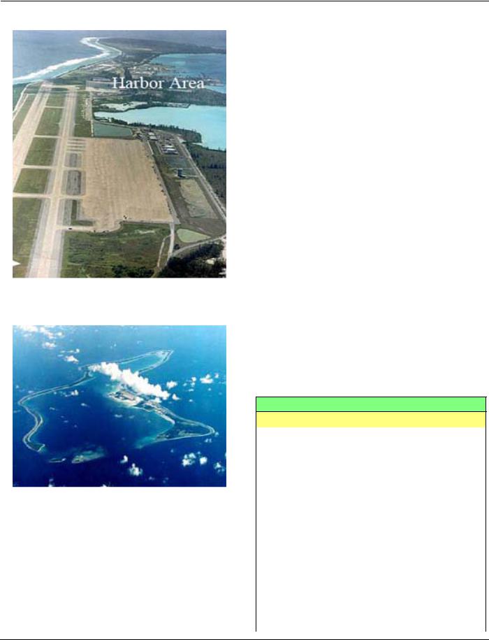
Diego Garcia (7°17'S., 72°24'E.)
World Port Index No. 47800
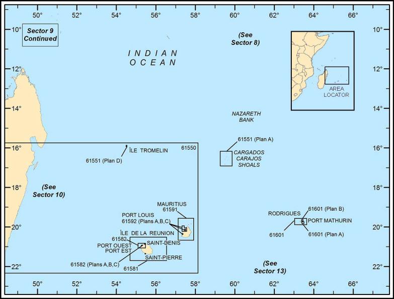
8.34 Diego Garcia is the farthest S of the islands of the Chagos Archipelago. It lies on an atoll, which is steep-to on its seaward side, and forms a natural harbor in an extensive lagoon which is entered from the NW side.
Diego Garcia is part of the British Indian Ocean Territory and is the site of a U.S. Communications Relay Station for military traffic that is run jointly with the United Kingdom.
Winds—Weather.—Because of the strength of the Southeast Trade Winds, a fresh to strong (force 5 to 6) breeze may be experienced at the anchorage with rough seas and an uncomfortable swell at the deep-draft wharf and the Supply and POL Pier.
Rain falls on most days, but is often limited to a short shower; droughts, however, sometimes last for a month. Frequent rain squalls occur at night.
Earthquake shocks are felt at times. Tides—Currents.—The tidal range at springs is 0.2m at
MLW to 1.9m at MHW.
In the approaches to the Main Pass, there is an E flow of about 1.5 knots about 2 hours before HW, and on the falling tide a W flow of about 1 knot. Rates of up to 4 and 2 knots, respectively, have been reported; the effect of this flow may be felt up to 8 miles seaward.
In the Entrance Channel, the tidal current sets SE on a rising tide and NW on the falling tide, with spring rates of 1.5 and 1.25 knots, respectively. In 1985, an outbound vessel experienced a sudden heavy E set about 0.3 mile before the sea buoys. The effect of the tidal current is barely perceptible 2 miles within the entrance.
When arriving, it is recommended that a long approach to the Entrance Channel be planned, in order to assess the effect of the set before entering the channel. The tidal current is reported to be unpredictable.
Depths—Limitations.—The Entrance Channel, formed between Spur Reef and West Island, is the recommended passage for entering the lagoon. A fairway, marked by buoys, has been
Pub. 171
138 Sector 8. West Indian Ocean—The Seychelles Islands to the Chagos Archipelago
Diego Garcia Harbor
Diego Garcia
dredged and swept.
The deep-draft wharf, 62.5m long, lies about 2 miles SSE of Eclipse Point and has a minimum depth alongside of 10.9m. The L-shaped Supply and POL Pier, about 0.8 mile SE of the deep-draft wharf, has a minimum depth alongside of 13m. The POL Pier has a berthing length, including dolphins, of 280m. Vessels with a maximum loa of 243.8m and a maximum draft of 10.97m can be accommodated.
Aspect.—From a short distance Diego Garcia appears to be covered with a bright green vegetation, fringed by a white sandy beach. The principal trees are coconut palms, which are
50m high in places; there are several clumps of casuarina trees on both sides of the island. The general height of the land is from 1 to 1.5m. The land is subject to alteration, being carried away at one part and raised at another by the seasonal monsoons. Eclipse Point is sparsely covered with trees, interspersed with buildings, and is easily identified. West Island, Middle Island, and East Island, lying on the reefs in the entrance to the lagoon, may be clearly distinguished at a distance of 5 miles. A radio tower stands 0.2 mile SSW of Eclipse Point, and a conspicuous tank is situated 0.5 mile SSW of the point; a radio tower, situated 0.3 mile NNE was not easily seen until within 8 miles from the island. There is a control tower situated at the root of the causeway, about 3 miles SSE of Eclipse Point, but it was reported to be surrounded by taller buildings and was not seen.
Pilotage.—Diego Garcia is a daylight port, although vessels may be taken in at night through prior arrangement with Diego Garcia Port Control. Pilots are compulsory on the vessel’s initial visit for both entry and departure. The boarding ground is located 2 miles NW of the channel entrance.
Regulations.—Access to the British Indian Ocean Territory is restricted and a permit is required. There are no commercial airline flights to the territory and permits are only issued to yachts in safe passage. The territory is not a tourist destination.
Access to Diego Garcia is only permitted to those with connections to the military facility. The British Indian Ocean Territory Administration in the United Kingdom Foreign and Commonwealth Office in London (http://www.fco.gov.uk) is responsible for issuing permits.
The are no medical facilities in the territory. Search and rescue facilities are limited. Comprehensive travel insurance, to include medical evacuation to the value of $100,000, and yacht insurance, to include wreck clean up and disposal, should be obtained before traveling.
Contact Information.—See the table titled Diego Garcia— Contact Information.
Diego Garcia—Contact Information
Port Control
Call sign |
Diego Garcia Port Control |
|
|
|
|
VHF |
VHF channels 12, 13, 14, 16, and 65 |
|
|
|
|
Radio |
2182 kHz |
|
|
|
|
Telephone |
246-370-4301 |
|
|
|
|
Facsimile |
246-370-3028 |
|
|
|
|
Hours |
24 hours |
|
|
|
|
chotoc@dg.navy.mil |
||
|
||
mathew.griffin@fe.navy.mil |
||
|
||
|
|
|
Web site |
http://www.cnic.navy.mil/regions/cnrj/ |
|
installations/nsf_diego_garcia.html |
||
|
||
|
|
|
|
Pilots |
|
|
|
|
Telephone |
246-370-4300 |
|
|
||
246-380-2218 |
||
|
||
|
|
|
gerald.partridge@kbr.com |
||
|
|
Pub. 171

Sector 8. West Indian Ocean—The Seychelles Islands to the Chagos Archipelago |
139 |
|
Diego Garcia—Contact Information |
|
|
|
|
|
|
Pilot Vessel |
|
|
|
VHF |
|
VHF channels 12, 14, and 65 |
|
|
|
|
|
Tugs |
|
|
|
VHF |
|
VHF channels 12, 14, and 65 |
|
|
|
Anchorage.—During the Northwest Monsoon, from the beginning or middle of December until the beginning or end of April, vessels should anchor on the W side of the lagoon under the lee of the land. Eclipse Bay, S of Eclipse Point, affords the
smoothest water during the monsoon, being protected by the point and the reef connecting it with West Island.
A vessel can anchor about 1 mile E of Point Marianne, in 16 to 18m, broken coral, good holding ground.
Anchorage is available in Orient Bay, Rambler Bay, and off East Point, as seen on the chart, but restrictions on access apply. For further details, consult the local authorities.
Caution.—A depth of 29m is located 0.7 mile ESE of Horsburgh Point. A depth of 18m is charted 1 mile SSW of South Point; its position is approximate.
Mariners are advised to use caution when navigating within the lagoon as there may be less water than charted and uncharted dangers may exist.
Pub. 171
171 .Pub
Additional chart coverage may be found in NGA/DLIS Catalog of Maps, Charts, and Related Products (Unlimited Distribution).
SECTOR 9 — CHART INFORMATION
141
Pub |
142 |
171 . |
|
Additional chart coverage may be found in NGA/DLIS Catalog of Maps, Charts, and Related Products (Unlimited Distribution).
SECTOR 9 — CHART INFORMATION
143
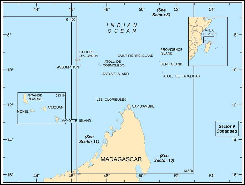
SECTOR 9
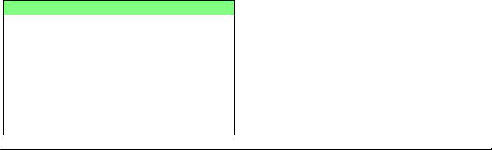
ISLANDS AND BANKS NORTH AND EAST OF MADAGASCAR
Plan.—This sector describes the Mascarene Ridge, Ile Tromelin, Ile de la Reunion, Mauritius, Cargados Carajos Shoals, and Rodrigues (Rodriguez Island). It then describes the Aldabra Islands, Assumption Island, Providence Island, the Farquhar Group, the Comoros Islands, and Iles Glorieuses.
The Mascarene Ridge
9.1 The Mascarene Abyssal Plain lies off the E coast of Madagascar where the continental slope drops to a depth of 5,914m. The Mascarene Basin rises NE and E of Madagascar between the Mascarene Abyssal Plain and the Mascarene Ridge. The depths in the Mascarene Basin range from 4,000 to 4,363m.
The Mascarene Ridge encumbers the Mascarene Basin on the NE and E side and contains a chain of detached plateaus. This formation of the Mascarene Ridge curves around the Mascarene Basin from Seychelles Bank, leads SSE to Agalega Island, continues SSW towards the Cargados Carajos Islands, continues on to Mauritius, and then extends to the detached rise where Reunion Island forms, a total distance of about 850 miles.
The banks and shoals on Mascarene Ridge, from N to S, are Fortune Bank, Poydenot Shoal, Soudan Bank, Nazareth Bank, Saya de Malha Bank, Souden Bank, and Cargados Carajos Shoals.
Caution.—Fishing vessels, with lengths of 10 to 35m, are active year-round on the Mascarene Ridge.
Vessels engaged in seismic surveys may also be encountered on Seychelles Bank and around the Madagascar coast; they should be given a wide berth.
Ile Tromelin
9.2 Ile Tromelin (15°53'S., 54°31'E.), a small low and sandy islet with bushes scattered about, is fringed by a narrow reef. The islet is part of the French Republic and is administratively attached to Reunion Island.
Ile Tromelin—Contact Information
|
|
Port |
|
VHF |
VHF channels 10 and 16 |
|
|
|
|
Radio |
14420 kHz |
|
||
|
|
|
|
Telephone |
870-764-593-241 (Inmarsat) |
|
|
|
|
881-631-41409 (Iridium) |
|
|
|
|
|
|
|
|
Facsimile |
870-764-593-243 (Inmarsat) |
|
|
|
|
dg-tromelin@skyfile.com |
|
|
|
|
|
Web site |
http://www.taaf.com |
|
|
|
Two shoals, with a depth of 10m, lie 0.75 mile NW of the NW extremity of the islet. A light is situated at the weather station which stands on this NW point.
During the Southeast Monsoon, anchorage can be taken in the lee of Ile Tromelin with the weather station bearing 113°, about 0.7 mile distant, in a depth of 13m, sand and coral; the holding ground is indifferent.
Strong overfalls may be seen off the NW side of Ile Tromelin, where the general current flowing W encounters the ebb current; the resulting breakers can be dangerous for small boats as far as 0.25 mile offshore.
Contact Information.—See the table titled Ile Tromelin— Contact Information.
Ile de la Reunion
9.3 Ile de la Reunion (21°06'S., 55°34'E.) is composed of a very narrow coastal plain, which is succeeded by hilly ground, which in turn rises inland to mountain masses and tableland. It is of volcanic formation, with many extinct craters. The mountain peaks are often visible at a distance of 100 miles or more. The island is a French possession.
La Perause Seamount, with a depth of 54m, lies 100 miles NW of Ile de la Reunion.
Volcan (Piton de la Fournaise) is an active volcano, 2,632m high, in the SE part of Ile de la Reunion; it frequently emits ashes. Slight earthquakes are frequent, however, the general volcanic nature of the island is clearly shown by the many extinct craters on the island.
Les Salazes, a mountain mass, rises near the middle of the island and during portions of nearly every winter, Piton des Neiges, 3,069m high, is snow-capped. Petites Salazes form three needle-pointed peaks, each about 2,286m high.
A mark for the SE end of the island is a black wavelike formation, formed by lava flow that solidified, that flowed toward the sea; it is nearly devoid of vegetation.
The roadsteads off the N side of the island are safer than those off the other sides. With gales from the N, a very violent sea beats upon the N coast of Ile de la Reunion from Saint-Paul to Sante-Rose.
Merchant vessels from abroad must first call at Sainte-Pierre, Saint-Paul, Le Port (Port des Galets), or Saint-Denis; permits are granted at these places to visit other places on the island. It is necessary to clear through one of these ports before leaving the island.
Winds—Weather.—Rainfall on the island varies greatly, not only from coast to coast, but from year to year; it is at maximum in summer. On Ile de la Reunion it reaches an annual average of 4,300mm at Saint-Benoit, on the E coast, and 990mm at Saint-Pierre, on the SW coast.
Rainfall tends to reach a maximum in the afternoon, except when the trade wind is well-established when it is more common at night.
Pub. 171

144 |
Sector 9. Islands and Banks North and East of Madagascar |
|
|
Regulations.—Vessels over 25m in length can only anchor in authorized or regulated anchorages areas. For further information, see Pub. 160, Sailing Directions (Planning Guide) South Atlantic Ocean and Indian Ocean.
Caution.—Fish aggregating devices, marked by orange, red, or yellow buoys equipped with radar reflectors, may be found up to 15 miles off the coast. A good lookout should be kept for these buoys; vessels should keep at least 1 mile clear of them.
9.4 Pointe des Jardins (20°52'S., 55°28'E.) is the N extremity of Ile de la Reunion. The Riviere Saint Denis flows into the sea through a deep ravine close W of Pointe des Jardins; a bridge spans the river near its mouth.
Saint-Denis (20°52'S., 55°28'E.) (World Port Index No. 47680), situated at Pointe des Jardins, is the capital and the most important town on the island.
The town, surrounded by vegetation, can be seen from a considerable distance; the high tower of the church is prominent.
Anchorage.—Anchorage off Saint-Denis is practically no longer used. From November to April, the stormy season, anchorage is possible, in depths of 18 to 31m, NW of Saint-De- nis. Vessels should be prepared to get underway at the first sign of stormy weather.
Between April and November, the fair season, vessels may approach land and anchor, in 24m, sand and broken shell, with the church steeple bearing 174°, 0.4 mile from the shore. A better anchorage is found a little farther SW, in 13m; this site is better sheltered from the swell.
Le Cousin, a dangerous sunken rock, lies about 0.2 mile offshore in a position about 1 mile E of Pointe de Sainte Marie. Cap Bernard, bearing 274°, and seen open N of the cathedral at Saint-Denis, leads N of Le Cousin.
Sainte-Suzanne is a village situated about 0.5 mile SE of Pointe de Bel-Air (20°53'S., 55°37'E.); the point is marked by a light.
Anchorage can be taken, in about 24m, 1 mile E of the light on Pointe de Bel-Air, but it is not recommended because of the bad holding ground and the difficulty of communicating with the shore.
There are storehouses on Pointe du Bourbier (21°01'S., 55°43'E.) that are visible from seaward. Anchorage can be taken off the point in a position about 1.3 miles ESE of the point, but is not recommended because of the bad holding ground and the difficulty of communicating with the shore. A church may be seen in the town of Saint-Benoit, which is situated about 1 mile SE of Pointe du Bourbier.
Sainte-Rose is a town with a small harbor protected by a breakwater situated about 6 miles SE Saint-Benoit. Anchorage is not recommended due to bad holding ground, unsurveyed areas, and the difficulty of communicating with the shore.
Caution.—A restricted area has been established along the coast between Saint-Denis and Port Est while a new coastal route is constructed. It is expected to be completed in 2018.
9.5 Pointe de la Table (21°19'S., 55°49'E.), the SE extremity of Ile de la Reunion, lies about 9 miles S of Pointe du Bambou. Within the coast is a hilly, arid region, Grand Brule, which has been deforested and crevassed by solidified flows of lava from the volcano Volcan.
Pointe de Bel-Air Light
Vessels should give the coast between Pointe du Bambou and Pointe de la Table a wide berth. A light is shown at Pointe de la Table.
From Pointe de la Table, the coast of Ile de la Reunion trends SW to Pointe de la Mare d’Arzule, 3 miles distant. The coast then trends in a general W direction to Pointe de Langevin (21°23'S., 55°39'E.), a distance of 7.3 miles, the S extremity of the island.
Pointe de Saint-Joseph is located 2 miles W of Pointe de Langevin and Pointe Riviere d’Abord is located 7.3 miles farther WNW; the 200m curve lies up to 1.3 miles offshore along this part of the coast.
9.6 Saint-Pierre (21°20'S., 55°29'E.) (World Port Index No. 47700) is situated on the S coast of Ile de le Reunion at the foot of the mountains on the W bank of Rivierre d’Abord; the port is very small and consists of a town, an artificial basin protected by breakwaters with lights, and an outer roadstead. Saint-Pierre can be identified from a considerable distance by its white buildings and church belfry. Lights, in line bearing 018°, lead into the inner harbor, which is no longer used because of silting.
Vessels may anchor with the church steeple bearing 018° and Pointe Riviere d’Abord bearing about 063°, in depths of 37 to
Pub. 171
Sector 9. Islands and Banks North and East of Madagascar |
145 |
42m, sand. A heavy swell sometimes occurs from May to September; a vessel must be ready to weigh anchor at any time of the year.
Pointe des Avirons (21°14'S., 55°20'E.) lies NW of SaintPierre; a light stands on the coast 1 mile SE of the point, and an aero beacon is situated 1.3 miles farther SE. Anchorage can be taken, in about 37m, about 0.8 mile SW of the point, but it is not recommended.
The villages of Saint-Leu and Saint-Gilles les Bain are situated near the coast, 5.3and 13 miles NNW, respectively, of Pointe des Avirons; a light is situated on the coast near each village.
Baie de Saint-Paul is entered between Cap la Houssaye (21°00'S., 55°14'E.) and Pointe de la Riviere des Galets. Baie de Saint-Paul is the best roadstead of Ile de la Reunion. Vessels at anchor here are usually sheltered when rollers are setting in at Saint-Denis.
Saint-Pierre—North Jetty Light
The roadstead at Saint-Paul is utilized as a waiting anchorage by vessels prior to entering Port de la Pointe de Galets (Port Ouest). Vessels are informed when they can enter port by the harbormaster’s office on VHF channel 16.
During the good season, anchorage can be taken with the signal mast bearing 124°, in 26m, muddy sand.
A wreck, with a depth of 39m, lies about 0.5 mile NNW of Saint-Paul Light. A wreck, with a depth of 22m, lies about 0.9 mile W of Saint-Paul Light.
Good anchorage can be taken with the signal mast bearing 240°; where the depths are 20m and the bottom is black sand. A mooring buoy is anchored about 0.7 mile W of the lighthouse.
During the good season, from about the middle of April to the middle of November, the wind is usually SW as a result of an eddy around this mountainous island. During the winter the
winds are usually NE and vessels should anchor farther offshore than mentioned above; depths of 37m are recommended in position NNW of the signal mast.
Caution.—A firing practice area lies SW of Saint-Pierre.
A seaplane operating area, best seen on the chart, lies in Baie de Saint-Paul, W of Saint-Paul.
A prohibited anchorage area, best seen on the chart, lies within Baie de Saint-Paul. A foul ground area lies adjacent to the NE of the prohibited anchorage area. Afish haven lies within the foul ground area.
Submarine cables, best seen on the chart, lie in Baie de Saint-Paul from the shoreline extending NW to 1.6 miles offshore near a prohibited anchoring area.
Port Reunion (Port de la Pointe des Galets) (20°55'S., 55°18'E.)
World Port Index No. 47690 (Port Est), 47695 (Port Ouest)
9.7 Port Reunion (Port de la Pointe des Galets) is comprised of Port Ouest (West Port or the “Old Port”), which is about 0.8 mile S of Pointe de Galets, and Port Est (East Port or the “New Port”), which is in Baie de la Possession.
Port Ouest is further subdivided into a N basin and a S basin.
Port Reunion Home Page
http://www.reunion.port.fr
Winds—Weather.—The port is subject to “rollers,” which are ocean waves which occur between April and October; their frequency is about 2 days per month. They occur in any weather and during perfect calm, unaccompanied by any change in atmosphere or other indication. The first appearance is a long swell not assuming the shape of a wave until it reaches the shore where it will break, with great violence, often causing damage to installations; they sometimes assume greater proportions than during a cyclone. This phenomenon usually lasts 24 hours, but can sometimes continue for 4 or 5 consecutive days. Masters would be advised to discontinue cargo operations and vacate the berth before the swell reaches severe proportions. From June to September, the S swell can cause a heavy undertow in Port Ouest.
Tides—Currents.—Generally, on the approaches to Ile de la Reunion, the current flows W when N of the island. West of the island the current is extremely variable. Offshore, about 3 miles from Pointe des Galets, the current sometimes reaches 3 knots. Nearer the coast it flows most often to the N at a speed not in excess of 0.8 knot.
There is a cross current in the entrance passes; in front of Port Ouest, it flows most often N, but does sometimes flow S. Its average speed is 1 knot, but can be as fast as 2 knots. In front of Port Est it flows W, and its speed does not exceed 1 knot.
A vessel should keep to the axis of the channel at a speed of 3 or 4 knots. When a vessel of great length passes between the mole heads, the bow will be held in still water while the stern is deflected by a current, which may have a rate up to 2 knots.
Depths—Limitations.—Port Ouest can accommodate vessels up to 14,000 gross tons, with a maximum length of 175m,
Pub. 171

146 |
Sector 9. Islands and Banks North and East of Madagascar |
|
|
Port Reunion
and drafts of less than 9m. Ship movements take place during daylight hours only.
Berthing details are shown in the accompanying table titled
Port Reunion—Berth Information.
The channel to Port Est is dredged to a depth of 13.1m over a width of 130m. The W arm of the basin is dredged to 12.8m.
Aspect.—The entrance to Port Est is protected by two jetties, the ends of which are each equipped with a light. Range lights, in line bearing 162°, lead through the channel.
The main lighthouse is situated on top of a cement silo; the large towers of which constitute a good landmark. A tower, with its red and white bands, 2 miles S of the harbor, serves as
a good landmark. It displays aerial obstruction lights which are occasionally visible from a distance of 28 miles.
Pilotage.—Pilotage is compulsory for all vessels over 50m in length and is available 24 hours for Port Est and from sunrise to sunset for Port Ouest. Vessels are requested to wait 2 miles from the entrance to either port. The pilot will call the vessel 10 minutes prior to boarding on VHF channel 12. Pilot boarding locations can be found in table titled Port Reunion
—Pilot Boarding Locations.
Regulations.—Vessels send their ETA via their agent and confirm it when within VHF range.
Vessels greater than 120m long are required to use a tug.
Port Reunion—Berth Information
|
Berth |
Length |
Depth |
|
Maximum Vessel |
|
Remarks |
||
|
|
|
|
|
|
||||
|
LOA |
Draft |
Beam |
|
Size |
||||
|
|
|
|
|
|
||||
|
|
|
|
|
|
|
|
|
|
|
|
|
|
|
|
West Port |
|
|
|
|
|
|
|
|
|
|
|
|
|
|
No. 1 |
160m |
8.0m |
— |
— |
— |
|
— |
Breakbulk |
|
|
|
|
|
|
|
|
|
|
|
No. 2 |
210m |
10.0m |
160m |
— |
— |
|
— |
Vegetable oils, fishing, multipurpose, and |
|
|
||||||||
|
|
breakbulk, |
|||||||
|
|
|
|
|
|
|
|
|
|
|
|
|
|
|
|
|
|
|
|
|
No. 3 |
100m |
— |
— |
— |
— |
|
— |
Navy berth. |
|
|
||||||||
|
|
|
|
|
|
|
|
|
|
|
No. 4 |
58m |
8.5m |
— |
— |
— |
|
— |
Navy berth. |
|
|
||||||||
|
|
|
|
|
|
|
|
|
|
|
No. 5 |
160m |
7.5m |
— |
— |
— |
|
— |
Navy berth. |
|
|
||||||||
|
|
|
|
|
|
|
|
|
|
|
No. 7 |
210m |
8.5m |
— |
— |
— |
|
— |
Sugar. |
|
|
||||||||
|
|
|
|
|
|
|
|
|
|
|
No. 8 |
190m |
10.0m |
175m |
8.65m |
24m |
|
— |
Clean products, dirty products, scrap metal, |
|
|
||||||||
|
|
cruise, multipurpose, and bunkers. |
|||||||
|
|
|
|
|
|
|
|
|
|
|
|
|
|
|
|
|
|
|
|
Pub. 171
|
|
|
|
Sector 9. Islands and Banks North and East of Madagascar |
147 |
||||||||
|
|
|
|
|
|
|
|
|
|
|
|
|
|
|
|
|
|
|
|
|
|
|
|
|
|
|
|
|
|
|
|
|
|
Port Reunion—Berth Information |
|
|
|
||||
|
|
|
|
|
|
|
|
|
|
|
|
|
|
|
|
Berth |
Length |
Depth |
|
Maximum Vessel |
|
|
Remarks |
|
|
||
|
|
|
|
|
|
|
|
|
|
||||
|
|
LOA |
Draft |
Beam |
|
Size |
|
|
|
||||
|
|
|
|
|
|
|
|
|
|
||||
|
|
|
|
|
|
|
|
|
|
|
|
|
|
|
|
No. 9 |
175m |
8.0m |
175m |
— |
24m |
|
21,336 dwt |
|
Animal feeds, grain, others, and bunkers. |
|
|
|
|
|
|
|
|
||||||||
|
|
|
|
|
|
|
|
|
|
|
|
|
|
|
|
Pier H |
75m |
8.0m |
145m |
7.8m |
22m |
|
21,366 dwt |
|
Aviation fuel, clean products, LPG, multi- |
|
|
|
|
|
|
|
|
||||||||
|
|
|
|
purpose, and cement. |
|
|
|||||||
|
|
|
|
|
|
|
|
|
|
|
|
|
|
|
|
|
|
|
|
|
|
|
|
|
|
|
|
|
|
TS |
45m |
8.5m |
— |
— |
— |
|
— |
|
Fishing vessels and bunkers. |
|
|
|
|
|
|
|
|
||||||||
|
|
|
|
|
|
|
|
|
|
|
|
|
|
|
|
|
|
|
|
|
East Port |
|
|
|
|||
|
|
|
|
|
|
|
|
|
|
|
|
|
|
|
|
No. 10 |
255m |
12.0m |
215m |
12.0m |
34m |
|
45,000 dwt |
|
Containers, clean products, ro-ro freight, |
|
|
|
|
|
|
|
|
||||||||
|
|
|
|
and multipurpose. |
|
|
|||||||
|
|
|
|
|
|
|
|
|
|
|
|
|
|
|
|
|
|
|
|
|
|
|
|
|
|
|
|
|
|
No. 11 |
255m |
12.0m |
215m |
12.0m |
— |
|
— |
|
Ro-ro freight and containers. |
|
|
|
|
|
|
|
|
||||||||
|
|
|
|
|
|
|
|
|
|
|
|
|
|
|
|
No. 14 |
255m |
12.0m |
215m |
12.0m |
— |
|
— |
|
PCC, beakbulk and containers. |
|
|
|
|
|
|
|
|
||||||||
|
|
|
|
|
|
|
|
|
|
|
|
|
|
|
|
No. 15 |
255m |
12.0m |
215m |
12.0m |
— |
|
— |
|
Cruise vessels, PCC, containers, and break- |
|
|
|
|
|
|
|
|||||||||
|
|
|
|
bulk. |
|
|
|||||||
|
|
|
|
|
|
|
|
|
|
|
|
|
|
|
|
|
|
|
|
|
|
|
|
|
|
|
|
|
|
No. 20 |
615m |
— |
— |
— |
— |
|
— |
|
Dirty products, multipurpose, and bulk car- |
|
|
|
|
|
|
|
|||||||||
|
|
|
|
|
|
|
|
|
|
go. |
|
|
|
|
|
No. 21 |
— |
— |
— |
— |
|
— |
|
|
|
||
|
|
|
|
|
|
|
|||||||
|
|
|
|
|
|
|
|
|
|
|
|
|
|
Port Reunion —Pilot Boarding Locations
|
Port Est |
20°53'42.0''S, 55°18'33.6''E |
|
|
|
|
Port Quest |
20°55'45.6''S, 55°15'29.4'’E |
|
||
|
|
|
Vessels should send an Offshore Advance Report to the harbormaster at least 24 hours prior to arrival, stating the following information:
1.Vessel name and type.
2.Last port and port of loading.
3.ETA at Reunion (Port Ouest or Port Est).
4.Draft.
5.Length overall.
6.Beam.
7.Summer draft.
8.Air draft.
9.Gross tons and net tons.
10.Port of registry, flag, and year built.
11.Call sign.
12.MMSI.
13.IMO Number.
14.Classification.
15.Ship security level.
16.Bow thruster.
17.Name and address of owners.
18.Cargo to be discharged at Reunion.
19.Dangerous cargo on board to be discharged and transit at Reunion.
20.Defects, if any.
21.Master’s name.
Signals.—The following signals are displayed for the regulation of traffic into Port Ouest:
1.Red flag—Entry prohibited.
2.Green flag—Departure prohibited.
3.Red flag over green flag—Entry and departure prohibited.
Contact Information.—See the table titled Reunion— Contact Information.
|
Reunion—Contact Information |
|
|
|
Port Authority |
|
|
|
Telephone |
|
262-2-6242-9000 |
|
|
|
Facsimile |
|
262-2-6242-4790 |
|
|
|
Web site |
|
http://www.reunion.port.fr |
|
|
|
|
Harbormaster |
|
|
|
|
Call sign |
Capitainerie Port Reunion |
|
|
||
Reunion Port Control |
||
|
||
|
|
|
VHF |
VHF channels 12 and 16 |
|
|
|
|
Telephone |
262-2-6271-1470 |
|
|
||
262-2-6271-1474 (East Port) |
||
|
||
|
|
|
Facsimile |
262-2-6271-1477 |
|
|
|
|
off-port@reunion.port.fr |
||
|
|
|
Pilots |
|
|
VHF |
VHF channel 12 |
|
|
Telephone |
262-2-6242-0314 |
|
|
secretariat@sppmr.re |
|
|
|
|
Marina |
|
|
VHF |
VHF channel 9 (0800-1500) |
|
|
Telephone |
262-2-6232-3192 |
|
|
Web site |
http://www.tco.re/plaisance |
|
|
Anchorage.—There is restricted anchorage 0.4 mile SW of the entrance of Le Port, in a depth of 40m, black sand bottom.
Pub. 171
148 |
Sector 9. Islands and Banks North and East of Madagascar |
|
|
Anchorage may not be taken without prior authorization by the Port Authority. For the protection of submarine cables, anchoring is prohibited within two areas, best seen on the chart, that lie close E and W of Port Est.
Directions.—The best maneuvering conditions are met at dawn or in the evening, because of the calm usually prevalent at these hours. When entering, large vessels must take into account the crosscurrent, the direction and speed of which are difficult to predict. At times vessels may find their bow in calm water while the stern is still subject to strong current.
Caution.—FAD buoys are located along the coast of Port Reunion. Caution is advised as fishing vessel traffic is heavy in this area.
Submarine cable, best seen on the chart, lies close E of Point des Galets, extending from the shore N to 0.5 miles offshore.
during disturbed weather in summer.
The W and N coasts of the islands are more sheltered and are dryer than the E and S coasts.
There are many streams and rivers, generally flowing through deep ravines, but none is navigable beyond a short distance from the sea; in dry season they are little more than brooks, but become raging torrents during heavy rains.
Tides—Currents.—The tidal currents around the islets on the bank extending NE from the NE side of Mauritius attain rates of 4 to 5 knots during springs, and form dangerous races. The rate at neaps seldom exceeds 2 knots. The currents at night are stronger than those during the day; the strongest occur 2 days after full and change of the moon.
The flood, or E current, begins 5 hours before the moon’s meridian passage and continues for 6 hours; the ebb, or W current, then sets in immediately and continues for 6 hours; there
9.8Pointe des Galets (20°54'S., 55°16'E.) is located 1 is no interval of SW. The E current sets with great strength over
mile N of the entrance to Port de Galets. This low point forms the NW extremity of an arid plain; Port des Galets is situated on the edge of this plain. Between Pointe de Galets and Cap de la Possession, 3.3 miles E, the coast is low.
From Cap de la Possession (20°55'S., 55°21'E.) to Pointe du Gouffre, the coast is high, steep, and broken by ravines; there are several cascades which fall to the sea from an elevation of 91m or more. Pointe de la Ravine a Malheur, 0.75 mile NE of Cap de la Possession, is a prominent headland.
From Pointe du Gouffre, the coast trends nearly 2 miles ENE to Pointe des Chiendents, then 1.4 miles farther ENE to Pointe des Jardins, the N extremity of Ile de la Reunion. The 20m curve lies up to 0.4 mile off this part of the coast.
Port Sainte-Marie (20°54'S., 55°32'E.) lies 15 miles E of Port Reunion. A prohibited anchorage area, best seen on the chart, a lies close N of Port Sainte-Marie.
Mauritius
9.9 Mauritius (20°15'S., 57°35'E.) is mostly fringed with coral reefs and is steep-to except on the NE side; depths of more than 180m are found from 1 to 1.5 miles offshore.
Winds—Weather.—The Southeast Trade Wind prevails throughout the year, with brief interruptions as described below; it is strongest and most regular in winter, from June to September, when it gives pleasant weather with sunshine predominating.
The trade wind is less dominant in summer when the weather may temporarily become unsettled. This occurs when the high pressure area over the South Indian Ocean becomes weaker; small depressions appear S of these islands and equatorial air reaches them. The air becomes hot and humid, with light winds, mainly from the N; blue sky at dawn soon gives way to heavy cumulonimbus clouds, with outbreaks of rain, especially in the afternoon. The sky clears at dusk. A warning sign of the onset of this type of weather is the deep blue appearance of mountain ridges and of distant vegetation.
As pressure rises and the trade wind returns, there may be a period of disturbed weather, with rain or drizzle and very low clouds on exposed coasts; the SE wind increases to Force 5 or 6 over the land and may reach Force 7 over the sea. This weather is very unpleasant if it occurs in April or May.
At Rodriguez, the trade wind may back to NE for a few days
The Carpenters and The Blacksmiths, and causes dangerous races as far as 3 miles off Gunner’s Quoin. Vessels should not pass this islet at distances of less than 1 mile.
The E current sets strongly onto Cannoniers Point, then sweeps through Quoin Channel and around the N end of Mauritius at a high rate. West winds cause an increase in the velocity; strong S winds deflect the current to the NE.
The tidal currents separate at LW off Piment Point, the N point of the entrance to Arsenal Bay, on the NW shore of Mauritius; the line of separation works toward Rocky Point, which lies about 2.3 miles NNE of Piment Point, and reaches Rocky Point by the time of HW. When the E current is setting around the N part of Mauritius, a weaker current sets S along the W shore of the island.
The so-called W current actually sets generally about WNW past the N end of the island, but is felt very little off the W shore of the island between Cannoniers Point and Caves Point. The inshore current turns 2 hours before the current in the offing, and during the last half of the flood sets E at a rate near Gunner’s Quoin of 4 knots. At the 20m curve skirting Mauritius, the W current has a rate of 3 knots.
Aspect.—The central and W parts of the island are mountainous. Piton de la Petite Riviere Noire (Piton Riviere Noire) rises in a position about 6.8 miles NE of the SW extremity of the island; it is pointed, and appears dark in clear weather, when it is visible for 50 miles. Pieter Both, a remarkable mountain, rises about 15.5 miles NNE of Piton de la Petite Riviere Noire; it has a huge knob on its summit. Piton du Milieu, near the middle of Mauritius, is a steep-sided cone. Mount Rempart, about 6.5 miles N of Piton de la Petite Riviere Noire, shows three needle-pointed peaks. All these mountains are useful marks for the island, but the summits are often enveloped in mist; among the summits are many extinct craters and extensive caves.
Caution.—A bank extends about 16 miles NE from the N extremity of Mauritius; several islands and lesser banks are located in this area.
A dangerous wreck, best seen on the chart, lies along the NE coast of Mauritius 2 miles SE of Grand Pointe (20°02'22.2''S., 57°42'43.2''E).
9.10 Serpent Island (19°49'S., 57°48'E.), the farthest NE of the dangers off Mauritius, lies near the NE extremity of the
Pub. 171
Sector 9. Islands and Banks North and East of Madagascar |
149 |
bank; it is 162m high. The SE and NW sides of the island are foul to a distance of 0.2 mile.
The sea breaks over Nab Reef, about 1 mile WSW of Serpent Island.
Round Island (19°51'S., 57°47'E.), 1.5 miles SSW of Serpent Island, is 322m high; it is the highest islet in this group.
In the channel between Serpent Island and Round Island, the tidal current attains a rate from 3 to 4 knots.
The Blinder is a submerged reef, which breaks occasionally, lying 0.25 mile W of the NW extremity of Round Island. Both the E and W tidal currents run with great strength over both The Blinder and Nab Reef.
La Caille Bank lies 2.8 miles SSW of Round Island; Abbe Bank lies 1 mile farther SSW. The sea occasionally breaks over these two banks in bad weather and Abbe Bank will occasionally break in good weather.
Flat Island (19°53'S., 57°39'E.) is the farthest NW of the islets N of Mauritius; it is generally flat, but the SW extremity rises to a hill, 102m high. Pigeon House Rock lies close N of Flat Island; it is 52m high. The N side of Pigeon House Rock is steep-to and may be safely passed as close as 0.3 mile; the current N of the rock flows E and W at rates of 2 to 4 knots; there may be tide rips encountered in this area.
Gabriel Island lies on the reef, about 0.4 mile SE of Flat Island, and Sandringham Reef extends 0.5 mile farther SE; the tidal currents set with great force over the reef, and it should be given a wide berth.
Vessels can anchor off the S end of Flat Island, with the light situated on the SW end of the islet bearing 315°, about 1 mile distant, and the summit of Serpent Island bearing 060°, in a depth of 16m. The holding ground of sand and coral is not good; moreover, the sea rises quickly with S winds so that vessels should proceed to sea at the first indication of bad weather. If a pilot is required, one will be sent from Port Louis.
Rip Bank, about 0.9 mile SE of Gabriel Island, has a least charted depth of 13m.
The NE extremities of Flat Island and Gabriel Island, in line bearing 316°, lead NE of Sandringham Reef and NE of Rip Bank; the disused light tower on Cannoniers Point, the NW extremity of Mauritius, bearing not less than 235°, and well open S of the S extremity of Gunner’s Quoin, leads S of Rip Bank.
Low-powered vessels arriving off Round Island during the E current should pass N of Serpent Island and should give Pigeon House Rock a berth of at least 1 mile.
Gunner’s Quoin (19°56'S., 57°37'E.) is an islet 3.5 miles SSW of Flat Island; it is separated from Mauritius by Quoin Channel, which is 0.9 mile wide between the 20m curves.
The Blacksmiths are a group of rocks which extend 0.3 mile NE of Gunner’s Quoin and The Carpenters are a group of rocks, awash, which extend 0.2 mile SE from the island; the sea breaks heavily over them.
The tidal current runs with great force N and S of Gunner’s Quoin, causing dangerous races up to 3 miles off the island. Vessels should not pass within 1 mile of this island.
Mapu Patch (19°59'S., 57°40'E.), with a depth of 13m, lies 3.5 miles SE of Gunner’s Quoin and 1.3 miles NE of Mauritius.
9.11 Cannoniers Point (20°00'S., 57°33'E.), the NW extremity of Mauritius, has a tower, formerly a lighthouse, situated on its
NW extremity; there is a dangerous set toward the point, which should be kept in mind.
Whale Rock (19°59'S., 57°33'E.), on the edge of the coastal reef, 0.5 mile NNW of Cannoniers Point, has a depth of 1.2m. The summit of Serpent Island, in line with the W extremity of Gunner’s Quoin bearing 056°, leads N of Whale Rock.
Rocky Point (20°03'S., 57°32'E.) lies about 3.3 miles SSW of Cannoniers Point; the fringing reef lies up to 0.8 miles off this part of the coast. From this vicinity, a gap in the trees on Cannoniers Point is conspicuous.
Balaclava Marine Park, best seen on the chart, lies in the vicinity of Pointe Piments (20°05'S., 57°31'E.). Entry is affected by numerous restrictions and prohibitions. Consult the local authorities for further information.
An anchorage prohibited area, best seen on the chart extends seaward from Tombeau Bay. Submarine cables lie in the vicinity.
Port Louis (20°10'S., 57°30'E.)
World Port Index No. 47720
9.12 Port Louis is of medium size and consists of a city, an outer roadstead, and an inner and outer harbor; it is the principal harbor of Mauritius. There are facilities for general cargo vessels and tankers and is the site of a bulk sugar terminal.
Mauritius Port Authority
http://www.mauport.com
Winds—Weather.—The harbor is sheltered from all winds except NW, which seldom blow with any strength, except in the cyclone season from December 1 to April 30.
When a cyclone is expected to pass within 300 miles of the island, a weather forecast is delivered daily to each vessel in port; more frequent forecasts are delivered or signaled during cyclone emergencies. Ships can expect at least 24 hours notice of a cyclone; about 3 day’s warning is normally given.
The most critical time during a cyclone is when the wind is on the beam. Provided the vessel is not too high out of water, there is a good chance of riding out the storm if the following procedure is complied with:
1.No attempt should be made to keep the ship broadside to the wind by holding on to windward cable and heaving the headlines taut; the headlines should be slacked down and the windward cable payed out, to allow the ship’s head to fall off the wind, even if this is towards and the side of the channel. Since the sides of the channel are steep-to, the bow will come to rest against the side of the channel with any surging to cease, and the stern moorings will not be disturbed.
2.Should the wind shift from one side of the ship to the other, as the cyclone passes over the island, the slack in the cable should be taken in and the other cable payed out, to allow the ship to fall off the wind as before.
3.No outside assistance can be given until the weather moderates; pilots are placed on the more vulnerable vessels.
4.Any vessel remaining in Port Louis more than 48 hours in the cyclone season should obtain special moorings from the port authorities.
Pub. 171

150 |
Sector 9. Islands and Banks North and East of Madagascar |
|
|
Tides—Currents.—At the entrance, the ebb current flows SW and the flood current flows NE. Tidal range is 0.5m.
Depths—Limitations.—Port Louis is a very simple harbor to navigate. The harbor entrance is well marked by navigation aids. Two maintained depth areas are located in the channel; the outer area is maintained to 13.5m, while the inner area is
dredged to 12.5m (2017). A turning basin, maintained to 12.5m, is located in the vicinity of the Ro-Ro Terminal, and is best seen on the chart.
English Channel, maintained to a depth of 16.5m, leads to the Mauritius Container Terminal. A turning basin, with a maintained depth of 16.5m, is best seen on the chart.
Port Louis—Berth Information
|
Berth |
Length |
Depth |
|
|
Maximum Vessel |
Remarks |
||
|
|
|
|
|
|
||||
|
|
LOA |
|
Draft |
Size |
||||
|
|
|
|
|
|
|
|||
|
|
|
|
|
|
|
|
|
|
|
|
|
|
|
Terminal 1 |
|
|
||
|
|
|
|
|
|
|
|
|
|
|
Friod de Mascareignes No. 1 |
60m |
— |
|
— |
|
8.5m |
— |
Fishing and reefer. Continuous berth |
|
|
|
|||||||
|
|
|
|
|
|
|
|
|
length 120m. |
|
Friod de Mascareignes No. 2 |
60m |
— |
|
— |
|
8.5m |
— |
|
|
|
|
|
|
|
|
|
|
|
|
Friod de Mascareignes No. 3 |
40m |
— |
|
— |
|
5.0m |
— |
Fishing vessels. |
|
|
|
|||||||
|
|
|
|
|
|
|
|
|
|
|
Friod de Mascareignes No. 4 |
50m |
— |
|
— |
|
2.5m |
— |
Fishing vessels. |
|
|
|
|||||||
|
|
|
|
|
|
|
|
|
|
|
Friod de Mascareignes No. 5 |
55m |
— |
|
— |
|
6.5m |
— |
Fishing vessels. Continuous berth |
|
|
|
|||||||
|
|
|
|
|
|
|
|
|
length 110m. |
|
Friod de Mascareignes No. 6 |
55m |
— |
|
— |
|
6.5m |
— |
|
|
|
|
|
||||||
|
|
|
|
|
|
|
|
|
|
|
Quay A |
210m |
12.2m |
|
— |
|
— |
— |
Dirty products, vegetable oils, grain, |
|
|
|
|
|
|
|
|
|
others, fast ferries, fishing, break- |
|
|
|
|
|
|
|
|
|
|
|
Quay D |
170m |
12.2m |
|
200m |
|
10.4m |
40,000 dwt |
bulk, multipurpose, and bunkers. |
|
|
|
|||||||
|
|
|
|
|
|
|
|
|
Continuous berth length 380m. |
|
|
|
|
|
|
|
|
|
|
|
|
|
|
|
|
|
|
|
|
|
Quay E |
135m |
9.0m |
|
— |
|
— |
— |
Fast ferry, breakbulk, multipurpose, |
|
|
|
|
|
|
and livestock. |
|||
|
|
|
|
|
|
|
|
|
|
|
|
|
|
|
|
|
|
|
|
|
|
|
|
|
Terminal 2 |
|
|
||
|
|
|
|
|
|
|
|
|
|
|
|
|
|
|
|
|
|
|
Clean products, dirty products, coal, |
|
No. 1 Quay |
123m |
13.5m |
|
183m |
|
11.0m |
40,000 dwt |
fertilizer, multipurpose, and bunkers. |
|
|
|
Berth length 171m (including dol- |
||||||
|
|
|
|
|
|
|
|
|
|
|
|
|
|
|
|
|
|
|
phins). |
|
|
|
|
|
|
|
|
|
|
|
|
|
|
|
|
|
|
|
Cement, coal, containers, and break- |
|
No. 2 Quay |
180m |
12.5m |
|
— |
|
— |
— |
bulk. Berth length 224m (including |
|
|
|
|
|
|
|
|
|
dolphins). |
|
|
|
|
|
|
|
|
|
|
|
No. 3 Quay |
185m |
12.5m |
|
— |
|
— |
— |
Cement, container, and breakbulk. |
|
|
|
|
|
|
|
|
|
|
|
No. 4 Quay |
185m |
12.2m |
|
— |
|
11.0m |
— |
Dirty products, LPG, containers, |
|
|
|
breakbulk, and bunkers. |
||||||
|
|
|
|
|
|
|
|
|
|
|
|
|
|
|
|
|
|
||
|
Note.—No. 2 Quay, No. 3 Quay, and No. 4 Quay have a continuous berthing length of 550m. |
||||||||
|
|
|
|
|
|
|
|
|
|
|
Mauritius Freeport |
118m |
7.0m |
|
— |
|
— |
— |
Fishing vessels and reefer. |
|
|
|
|
|
|
|
|
|
|
|
|
|
|
Bulk Sugar Terminal |
|
||||
|
|
|
|
|
|
|
|
|
|
|
|
|
|
|
|
|
|
|
Dirty products, sugar, and multipur- |
|
BST Jetty |
210m |
12.5m |
|
— |
|
11.0m |
— |
pose. Berth length 344m (including |
|
|
|
|
|
|
|
|
|
dolphins). |
|
|
|
|
|
|
|
|
||
|
|
|
Christian Decotter Cruise Terminal |
|
|||||
|
|
|
|
|
|
|
|
|
|
|
Cruise Jetty |
124m |
12.5m |
|
— |
|
— |
— |
Passengers. |
|
|
|
|
|
|
|
|
||
|
|
Terminal 3 (Mauritius Container Terminal) |
|
||||||
|
|
|
|
|
|
|
|
|
|
|
MCT1 |
400m |
16.5m |
|
366m |
|
15.5m |
— |
Containers. Continuous berth length |
|
|
|
|
|
|
|
|
|
807m. |
|
MCT2 |
400m |
16.5m |
|
366m |
|
15.5m |
— |
|
|
|
|
|
|
|
|
|
|
|
Pub. 171

|
|
Sector 9. Islands and Banks North and East of Madagascar |
151 |
||||||||
|
|
|
|
|
|
|
|
|
|
|
|
|
|
|
|
|
|
|
|
|
|
|
|
|
|
|
|
Port Louis—Berth Information |
|
|
|
||||
|
|
|
|
|
|
|
|
|
|
|
|
|
Berth |
|
Length |
Depth |
|
Maximum Vessel |
Remarks |
|
|
||
|
|
|
|
|
|
|
|
||||
|
|
LOA |
|
Draft |
Size |
|
|
||||
|
|
|
|
|
|
|
|
|
|||
|
|
|
|
|
|
|
|
|
|
|
|
|
|
|
|
|
Tanker Terminal |
|
|
|
|
||
|
|
|
|
|
|
|
|
|
|
|
|
|
|
|
|
|
|
|
|
|
Aviation fuel, clean products, dirty |
|
|
|
Oil Jetty |
|
70m |
16.0m |
— |
|
13.0m |
75,000 dwt |
products, and LPG. Berthing length |
|
|
|
|
|
of 270m (including dolphins). Gas |
|
|
||||||
|
|
|
|
|
|
|
|
|
|
|
|
|
|
|
|
|
|
|
|
|
capacity 84,000m3. |
|
|
Berthing details are shown in the accompanying table titled
Port Louis—Berth Information.
A platform, best seen on the chart, is located seaward of the cruise terminal and is reported to be used for secure mooring lines.
Aspect.—The cement silos situated near Berth No. 2 are conspicuous and make a good mark, as do the tanks 230m NW of the silos.
Port Louis Harbor
Port Louis—Bulk Sugar Terminal
The Citadel, situated near the range line 1.2 miles SE of the
cement silos, has a mast, with an elevation of 106m, situated at its SE corner and Signal Mountain are conspicuous.
Other good marks from seaward are Le Pouce (20°12'S., 57°31'E.), 811m high, which resembles a thumb held upright, and Pieter Both (20°11'S., 57°35'E.), 811m, high which is surmounted by a knob-like formation.
A lighted beacon with a racon stands 0.36 mile NW of the oil jetty.
It has been reported (2015) that the lighted range is easily visible on the inbound transit, with the front light on a skeleton tower and the rear light on the “MCB” building in the city.
Pilotage.—Pilotage is compulsory for all merchant vessels over 100 gt and is available 24 hours. The pilot boards about 1.8 miles NW of the entrance buoys.
Regulations.—Vessels should send their ETA to the harbormaster via the agent 24 hours in advance, stating length, draft, and tonnage (gt or nrt), confirming these details 2 hours in advance on VHF channel 12 or 16.
Arriving vessels should have both anchors ready for letting go, and two hawsers and two wires ready aft, before the pilot embarks.
Signals.—The conspicuous signal tower at the signal station at Fort William, on the S side of the entrance, is 21.3m high and painted in black and yellow checkers; there is a white iron flagstaff on a tripod.
Contact Information.—See the table titled Port Louis—
Contact Information
Anchorage.—There is anchorage in the outer roadstead, about 1.3 miles NW of Fort George, in depths of 27 to 33m, sand and coral. An uncharted dolphin has been reported (2015) to lie N of the anchorage.
Port Louis—Contact Information
|
Port Authority |
Telephone |
230-206-5400 |
|
|
Facsimile |
230-240-0856 |
|
|
info@mauport.com |
|
|
|
Web site |
http://www.mauport.com |
|
|
|
Harbor Radio |
|
|
|
|
Call sign |
Port Louis Harbor Radio |
|
|
|
|
VHF |
VHF channels 12, 14, and 16 |
|
|
|
|
Telephone |
230-216-9074 |
|
|
||
230-216-9081 |
||
|
||
|
|
Pub. 171
152 |
Sector 9. Islands and Banks North and East of Madagascar |
|
|
Port Louis—Contact Information
Facsimile |
230-216-9078 |
|
|
harbourradio@mauport.com |
|
|
|
|
Pilots |
|
|
VHF |
VHF channels 12, 14, and 16 |
|
|
Telephone |
230-242-0458 |
|
|
Facsimile |
230-216-3253 |
|
|
|
Tugs |
|
|
VHF |
VHF channels 12 and 14 |
|
|
The quarantine anchorage, whose position may be seen on the chart, is situated on the SW side of the entrance range, NW of the signal station.
Anchorage is prohibited in an area W of the signal station, in an area of submarine cables.
For vessels anchoring in the outer roadstead, the following is the advice of a former experienced harbormaster:
When anchoring in the outer roadstead, from the moment of anchoring, vessels should be ready to weigh anchor and put to sea if necessary. Use chain for a buoy rope. If the signal is made to put to sea, do so at once, and never attempt to ride out the storm. When leaving the anchorage from stress of weather, note the direction in which the wind shifts, and run the vessel in the opposite direction until clear of the land, when an E course will take its into good weather. Never heave-to with the vessels head toward the shore; in bad weather, local currents are often very strong and uncertain in direction; many vessels, in the belief that they had made a sufficient offing, have been hazarded, and some lost, through neglecting this precaution.
Directions.—Vessels approaching Port Louis at night from the SW should pass from 1 to 1.5 miles off Pointe Aux Caves Light on a course of 040°, until the entrance range lights are in range bearing 127°. The aft range light is conspicuous on the mountain behind the city, but the forward range is a white square on top of a building that is more difficult to see. Then alter course to 127° and take up anchorage in the outer anchorage.
Vessels approaching Port Louis from the NE should pass about 5 miles W of Flat Island Light (19°53'S., 57°39'E.); when that light bears 090°, a course of 205° should be steered. Pointe Aux Caves Light should be picked up on that course. When the entrance range lights are in line bearing 127°, alter course to that bearing and take up anchorage in the outer anchorage area.
By day, local knowledge is recommended, as the entrance range marks are difficult to identify.
Caution.—A works in progress area (2013), marked by buoys, lies approximately 0.5 mile W of the port entrance.
It has been reported (2015) that large numbers of small fishing boats moored to Buoys 5-10 abreast create obstructions in the vicinity of the Bulk Sugar Terminal and Quays A and D.
9.13 Grand River Bay (20°10'S., 57°28'E.) on the W side is formed at the mouth of the Grand River, where it enters the sea through a gap in the reef; the reef extends 0.7 miles offshore in this area. Martello Tower, which is conspicuous,
stands on the SW shore of the bay.
Pointe aux Caves (20°11'S., 57°24'E.) is marked by a light; the 20m curve lies 0.2 mile off the point.
Pointe Petite Riviere, 0.7 mile SW of Pointe au Caves Light, is the N entrance point of Petite Riviere Bay, which is almost filled by a reef.
Baie du Tamarin (20°19'S., 57°22'E.) has depths convenient for anchoring, but the holding ground is bad.
Grande Riviere Noire Bay is entered about 2.3 miles SSW of Baie du Tamarin. The bay is easily identified by a tower situated on the N entrance point, and by Tamarin Mountain (20°21'S., 57°23'E.), which rises from the NE shore to a height of 548m.
Anchorage.—Anchorage can be taken in Grand Riviere Noire Bay. After obtaining pratique at Port Louis, a mid-chan- nel course between the reefs flanking the entrance should be steered; the reefs are easily seen.
Anchorage can be taken as convenient, in 10m to 28m. The anchorage is good, but with W winds a heavy swell sets in; the swell is felt less in positions toward the N side of the bay. Vessels should be prepared to leave the anchorage on short notice.
Pointe Sud Ouest (20°28'S., 57°18'E.) is the SW extremity of Mauritius. Pointe Sud Ouest is low and rises to a height of 556m at Le Morne Brabant, an isolated flat-topped hill 1.2 miles NE; the hill is an excellent landmark.
Tides—Currents.—During springs, the currents run over the bank W of Pointe Sud Ouest at rates from 3 to 5 knots causing considerable rips. The flood current runs ESE and the ebb current WNW along the S coast, but immediately N of the point the currents follow the coastline, the flood running NNE and the ebb running SSW at a rate of 2 to 3 knots.
Flinders Bank (20°35'S., 57°09'E.), about 1 mile in diameter, has a least charted depth of 101m.
9.14 South side.—From Pointe Sud Ouest, the S coast of the island trends ESE to the mouth of the River Savanne, which enters the sea close W of the S extremity of Mauritius.
Bel Ombre (20°31'S., 57°24'E.) is a narrow opening in the barrier reef about 5.5 miles E of Pointe Sud Ouest; a beacon stands on the reef on the E side of the entrance.
Bay Jacotet is an indentation abreast an opening in the reef, 3 miles E of Bel Ombre. The S extremity of Mauritius lies 5 miles ESE of Bay Jacotet, and Souffleur Point (20°29'S., 57°40'E.) lies 9 miles ENE of the S extremity.
Blue Bay Marine Park, best seen on the chart, lies about 2 miles SW of Pointe d’Ensy. Entry is affected by numerous restrictions and prohibitions. Consult the local authorities for further information.
Grand Port (20°24'S., 57°42'E.) is entered E of Pointe d’Esny (20°25'S., 57°44'E.); it is an extensive harbor and extends about 8.3 miles NNE. The three entrances to the bay are exposed to the full force of the Southeast Trade Wind and to the ocean swell. Reefs and banks border the shoreline and it is unapproachable.
Pointe Laverdure (20°25'S., 57°46'E.), which dries, lies at the edge of a reef, extending just over 2 miles E of Pointe D’Esny. Heavy rollers form nearly all the time over Laverdure Spit, 0.5 mile ESE of the point. Ile de la Passe, 11.6m high, lies 1 mile N of Point Laverdure; the ruins of a fort are situated on the islet.
Pub. 171

Sector 9. Islands and Banks North and East of Madagascar |
153 |
The S entrance to Grand Port is formed S of Ile de la Passa and Danish Entrance, which is not recommended, and is formed at the N extremity of a reef, which dries in places, extending about 4.5 miles NNE from Ile de la Passe.
Ile aux Fouquets (20°24'S., 57°47'E.) lies on the edge of the reef 0.6 mile ENE of Ile de la Passe; a prominent disused light stands on the islet.
Ile aux Oiseaux (20°20'S., 57°49'E.) stands on the SW part of the reef, on the N side of Danish Entrance. The reef extends 1.2 miles NNE from the islet. Great South Point is the spit extending NNE from the reef; it breaks heavily at all times.
Ilot de Roches, on the N side of the North Entrance, lies just over 1 mile NNW of Great South Point; a beacon stands on the islet. Ilot de Roches marks the E edge of the reef, which extends 2 miles from the N entrance point of Grand Port.
Tides—Currents.—The tides are much influenced by the winds. During strong SE winds, the HW stand sometimes last for several hours at and near Mahebourg, in the SW corner of the port.
In the South Entrance, the flow of water is nearly always out; the ebb may attain a velocity of 0.5 knot during a strong wind. The water may stand still during a flood tide.
In the North Entrance, both flood and ebb currents are regular and, though never strong, vary a good deal in velocity.
Aspect.—The Bambou Mountains rise over the NE part of Grand Port; the most conspicuous peaks on the range include:
1.Grand Port Mountain, near the SW extremity of the range, 4 miles N of Pointe D’Esny (20°25'S., 57°44'E.).
2.The outline including Lions Head, 0.4 mile SE, resembling the Sphinx facing inland.
3.Mount Bambou, 2.7 miles NNE of Lions Head.
The Thumb is a conspicuous upright column of stone, 0.1 mile E of Mount Bambou.
Point Bambou lies about 1 mile SSW of Pointe du Diable (20°20'S., 57°47'E.). Piton Rouge, just within Pointe Bambou, is a useful mark for vessels entering Grand Port by way of North Entrance. Mount Chat, 0.2 mile NNE of The Thumb, is distinctive from N and E of Pointe du Diable. A conspicuous white bungalow, with a black roof, stands just over 1 mile SW of Piton Rouge.
Anchorage.—Anchorage can be taken in Horseshoe Bight, close within Southern Entrance, with the SW extremity of Ile de la Passe bearing 161°, 0.3 mile distant, and Ile aux Fouquets disused lighthouse bearing 102°. This anchorage is on Annanas Bank and has depths of 10 to 14m.
The next most frequented anchorage is N of Petit Pate (20°23'S., 57°44'E.), 2 miles farther WNW of Annanas Bank, in a clear space 0.3 mile wide, with depths of 12 to 16m, mud.
Anse d’Hercule, 1.5 miles NNE of Petit Pate, affords anchorage, in a depth of 20m, mud.
Directions.—Three entrance channels, South Entrance, Danish Entrance, and North Entrance, lead through the reefs lying off the bay. Danish Entrance is not considered a safe channel.
All of these entrances are exposed to the Southeast Trade Wind, and swells from this source are often of considerable size.
Other problems met with by deep-draft vessels proceeding to and from Grand Port are the narrow fairways, rocks, and shoals in the inner anchorage areas.
Caution.—A stranded wreck, best seen on the chart, lies 1 miles ESE of Pointe d’Esny.
9.15 Northeast side.—From Ilot de Roches (Ile des Roche) (20°18'S., 57°49'E.) to Cape Malheureaux, the N extremity of Mauritius, a reef extends up to 2.5 miles from the coast. The reef has some openings, suitable only for boats, and encloses a number of bays, where several small rivers enter the sea.
There are no anchorages of any significance along this coast; the boats which enter the breaks in the barrier reef should have local knowledge.
Cargados Carajos Shoals
9.16Cargados Carajos Shoals (16°38'S., 59°36'E.) is an extensive group of reefs, islets, and shoals. They have been reported to lie about 3 miles further SW than charted. The E side of the reef has not been closely examined, because it is almost impossible to approach it from the E; in addition to the tremendous sea always breaking over it, is reported to be steep-to, and, therefore, most dangerous to approach under any circumstance. Several small islets and rocks rise from the long central reef of Cargados Carajos Shoals, and others lie off its N end and its W side. All of them are low; many are subject to being submerged in heavy weather.
Albatross Island (16°15'S., 59°35'E.) is about 3m high and is marked by a light. When viewed from the N, the light may be obscured by trees.
North Island, surrounded by coral reefs, lies 2.5 miles NNE from the main reef; depths off its W side are about 12.8m, but the E side is unsurveyed. Breakers are charted 1.8 miles NNE of North Island and isolated depths of 2.1m lie 1 and 1.3 miles SSE, respectively, of the island.
Ile Raphael (16°27'S., 59°37'E.) is a group of three islets visible at a distance of about 10 miles. There are fishermen’s huts and a meteorological station on the islets; they are situated in the N part of the extensive shoal.
Siren Island lies 1.8 miles SW of Ile Raphael. Pearl Rock lies 3.8 miles SSW of Siren Island.
Pearl Island (16°33'S., 59°31'E.) lies 2.3 miles SSW of Pearl Rock; it is bare of vegetation, except for a conspicuous clump of trees on its NE end.
Frigate Island lies about 5.3 miles W of the extensive shoal area in a position 3 miles S of Pearl Island.
Mapare Island and Avocare Island lie about 10 miles SSE and 9.5 miles S, respectively, of Ile Raphael. Trees grow on both islands and are visible from a distance. Avocare Island can be approached from the W by small vessels with local knowledge, although such approach is difficult because of numerous coral heads and other dangers.
9.17Baleine Rocks (16°41'S., 59°31'E.), an isolated group of rocks. The swell usually breaks over these rocks, but in good weather, with a calm sea, the position of the rocks, which is approximate, can be seen by discoloration of the water.
Coco Island (16°49'S., 59°31'E.) is located close within the S extremity of the primary reef, 8 miles SSW of Baliene Rocks.
Tides—Currents.—At the anchorage of Ile Raphael, the tidal
Pub. 171

154 |
Sector 9. Islands and Banks North and East of Madagascar |
|
|
currents are felt strongly in both directions; the N current is the stronger. Off Frigate Island they are very slight; the S current only is distinguishable. At the anchorage off Coco Island, the tidal current sets N when the tide is rising, at a velocity of about 0.5 knot. Here, the S current is barely perceptible.
In the month of August, a strong current setting W was experienced off the S side of Cargados Carajos Shoals.
Cargados Carajos Shoals should not be approached at night. A vessel approaching during the daytime from the S should steer for the long central reef. The SW extremity of this reef may be rounded at a distance of 1 mile. Vessels approaching from the N during the daytime should make for Albatross Island.
Anchorage.—There are several anchorages in Cargados Carajos Shoals; all them should be approached from the W. There is an anchorage about 0.4 mile WNW of Ile Raphael, in a depth of 18m, one about 1.5 miles SSW of that islet, and 0.75 miles E of Siren Island in a depth of 20m. There is an anchorage, in 22 to 26m, 0.3 mile N of Frigate Island.
There is anchorage in the bight NE of Coco Island, at a distance of 2, 3, and 4.3 miles NNE of the light; vessels should not anchor in less than 20m in these berths.
Rodrigues
9.18 Rodrigues (Rodrigues Island) (19°42'S., 63°25'E.) is of volcanic formation and a dependency of Mauritius. A mountain range extending E and W across the island reaches a height of 396m in Mount Limon. Rows of peaks, separated by deep ravines, connect the central range to the N and S coasts of the island. The island is composed principally of basalt, but at either end is some upraised coral. It is hilly throughout; a central ridge trends ENE and WSW through the middle of the island along nearly its entire length. Spurs from the central ridge extend to the N and S coasts of the island; between the spurs are deep ravines. The W portion of the island is more or less broken into isolated hills and is generally lower than the E portion.
Rodriguez is connected with the general submarine cable system and has periodic communication by sea with Mauritius and Madagascar.
Tides—Currents.—During the Southeast Trade Winds, there is a constant W current at a velocity of 0.2 to 0.6 knots.
An extensive coral bank, with a least known depth of 42m, lies 90 miles W of Rodrigues. The limit of the bank, as defined by the 180m curve, appears to be about 10 miles in extent. The general depths over the bank are from 70 to 73m; the E limit of the bank has not been determined. The bottom for about 15 miles around the bank is most irregular; depths from 366 to 549m are found in close proximity to those from 1,829 to 3,658m.
Rodrigues is surrounded by a coral reef which projects about 0.1 mile off the NE side, 4.5 miles off the NW side.
The reef, which is flat, partially uncovers and bares numerous islets; during LWS, some parts may have 0.3 or 0.6m over them. The reef is steep-to, but with the swell that rolls in, the sea often breaks in depths of 18.3m more than 0.1 mile outside the actual reef. The heaviest breakers may be found on the SW extremity of the encircling reef. In light winds a vessel can anchor almost anywhere outside the reef, in depths of 18 to 37m.
There are many islets on the reef, which may be seen on the
chart; Crab Islet, 46m high, lying 0.6 mile W off the S extremity of the island, is the highest of these islands.
Pilotage.—Pilotage for the island is not compulsory; a local boatman is always available for vessels that need advice as to the channels.
9.19 Port Mathurin (19°41'S., 63°25'E.) (World Port Index No. 47750) is situated on the N coast of Rodrigues; it consists of a large village situated on a mud bank, and is the principal settlement and administrative center of the island.
Port Mathurin
Quay at Port Mathurin
Depths—Limitations.—Mathurin Bay is the only harbor of Rodrigues available to deep-draft vessels.
It was reported (1978) that a depth of 18.3m was indicated by depth meter in position 19°37.28'S, 63°24.30'E. A depth of 35m is charted in this position.
The channel leading to Port Mathurin was reported to have been dredged to 8.8m in 1990.
Aspect.—Mont Piton shows as a rounded cone and is quite unmistakable from the vicinity of Mathurin Bay, but when seen
Pub. 171