


Chapter 3
Geology and Geomorphology of Azokh Caves
Patricio Domínguez-Alonso, Enrique Aracil, Jose Angel Porres, Peter Andrews, Edward P. Lynch, and John Murray
Abstract Azokh Cave is located in the Lesser Caucasus and is hosted in Mesozoic limestone. It comprises a series of karstic cavities, chambers and passageways that interconnect to form a larger cave network, the trend of which appears to have been influenced by fracture patterns in the bedrock. The geomorphology of the currently accessible areas of the cave is presented, with many of its speleological features described in detail for the first time. Electrical resistivity tomography is used to examine variation in thickness of sediments infilling the inner chambers of the cave. This information, coupled with data relating to the surface topography of the cave infill, sheds light on patterns of sediment deposition within the cave system. It remains unclear whether the cave formed from epigenic or hypogenic speleological processes (or a combination of the two). This question is further hampered by the presence of a
Patricio Domínguez-Alonso – Deceased
P. Domínguez-Alonso
Departamento de Paleontología, Facultad de Ciencias Geologicas & Instituto de Geociencias (IGEO-CSIC), Universidad Complutense de Madrid (UCM), Madrid, Spain
E. Aracil
Análisis y Gestión del Subsuelo, S.L. (AGS), c/Luxemburgo, 4; Oficina 3; E-28224-Pozuelo de Alarcón, Madrid, Spain
e-mail: e.aracil@ags-geofisica.com
E. Aracil J.A. Porres
Departamento de Geodinámica. Facultad Ciencias Geológicas., Universidad Complutense de Madrid (UCM), c/ José Antonio Novais n. 12, 28040 Madrid, Spain
e-mail: japorres@ubu.es
P. Andrews
Natural History Museum, Cromwell Road, London, SW7 5BD, UK
e-mail: pjandrews@uwclub.net
E.P. Lynch J. Murray (&)
Earth & Ocean Sciences, School of Natural Sciences, National University of Ireland, Galway, University Road, Galway, Ireland e-mail: john.murray@nuigalway.ie
E.P. Lynch
e-mail: Edward.lynch@nuigalway.ie
large bat population in the interior of the cave, the guano deposits of which have modified the inner galleries.
Резюме Полное и детальное описание геоморфологии пещерной системы Азоха представлено здесь впервые. Пещера сформировалась в богатой карстовой сети мезозойского известняка и состоит из четырех больших внутренних камер (помеченных как галереи Азоха I–IV), которые латерально связаны между собой и расположены в направлении от северо-запада на юго-восток. С внешним миром камеры связаны посредством ряда перпендикулярно выходящих проходов (Азох 1, 5 и 6). Эти пещерные каналы имеют одинаковую ориентацию с региональной особенностью соединения на уровне бедрока. В геоморфологии пещеры явно заметны признаки карстового провала. В одном из “слепых” внешних проходов (Азох 2) доступ к внутренним галереям заблокирован. Образование черта (сланца) в известняке имело обратный эффект: на местах он укреплял и поддерживал структуры потолка, помогая сохранить различные камеры пещеры. На перекрестной топографии пещеры заметна высокая центральная зона (между внутренними камерами Азох 2 и Азох 3) с уклоном в сторону двух концов пещерной системы, хотя это снижение несколько более выражено по направлению к проходу Азох 1.
Толщина седиментного слоя в различных камерах пещеры определена геофизическим методом – вычислением удельного электрического сопротивления. Этот подход позволяет картировать заполненную толщину внутри пещеры, иэтавеличинаварьируетвпределахот <1 мдо 3 м+. Максимальная толщина седимента отмечена в камере Азох 1, хотя участки с большой толщиной встречаются и у входа в Азох 2, а также в более центральных местах камер Азох 2, 3 и 4. С помощью компьютерной программы Surfer была вычислена площадь поверхности (примерно 1,390 м2) большого объема седимента (около 1,367 м3), лежащего на известняковом бедроке во внутренних галереях Азохской пещеры.
© Springer Science+Business Media Dordrecht 2016 |
55 |
Yolanda Fernández-Jalvo et al. (eds.), Azokh Cave and the Transcaucasian Corridor,
Vertebrate Paleobiology and Paleoanthropology, DOI 10.1007/978-3-319-24924-7_3
56 |
P. Domínguez-Alonso et al. |
Геофизические профили выявляют также различные аномалии внутри известняка, которые, судя по их морфологии и величинам удельного сопротивления, возможно, представляют собой полости в бедроке, заполненные, как правило, мелкозернистым материалом. Все обнаруженные полости обычно ассоциированы с аномалиями проводимости в профилях, причинами которых являются разломы. Это подтверждает взаимосвязь между развитием разлома, образованием карстового рельефа и формированием полостей.
Остается неясным, сформировалась ли Азохская пещера под воздействием поверхностных вод, уходящих в почву и растворяющих нижележащий известковый бедрок (эпигенетический спелеогенез), или альтернативно, т.е. поднимающейся снизу водой, растворяющей горную породу (гипогенетичесский спелеогенез). Возможно также сочетанное влияние этих двух процессов. Рассматриваемая проблема усложняется из-за наличия большой колонии летучих мышей в пещерной системе. Толстые отложения гуано, выработанные этими существами, в некоторых направлениях изменили (и продолжают изменять) поверхность внутренних галерей.
Keywords Lesser Caucasus Limestone Karstic Electrical resistivity Epigenic Hypogenic
Introduction
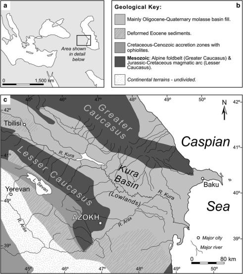
Azokh Cave is located at the southern end of the Lesser Caucasus at 39° 37.15′ north and 46° 59.32′ east (Fig. 3.1). The wider region surrounding the site effectively marks the boundary between Europe and Asia. Both the Lesser and Greater Caucasus (positioned further north; see Fig. 3.1c) run broadly parallel to each other and formed during the Himalayan-Alpine orogeny in Late Mesozoic to Cenozoic times. These two mountain ranges cross the Caucasian isthmus between the Black and Caspian seas and they are separated by the intermontane Kura Basin, which contains Paleogene to Quaternary molasse sediments.
The cave is part of a much larger karst network developed in Mesozoic limestone, which is now abandoned. It contains an appreciable amount of sediment infill and, as it is presently home to one of the largest bat populations in the Southern Caucasus, thick deposits of guano are present in the interior.
Murray et al. (2010) recently described between 11 and 12 m of sediments infilling the largest of the entrance passages to the cave [Azokh 1]. This particular passage had been extensively excavated in the past by a Soviet-Azeri team (Huseinov 1985; Ljubin and Bosinski 1995; Lioubine 2002) and the stratigraphy remaining is split between two
sedimentary sequences, which are no longer physically connected. The lower (and presumably oldest) of the two sequences is very limited in extent and has produced very few fossils; however, the upper sequence, preserved at the rear of the passage, has produced abundant fossil specimens, including numerous types of macroand micro-mammals (Fernández-- Jalvo et al. 2010). The base of the upper sequence is dated between 200 and 300 ka (i.e. Middle Pleistocene), whilst the uppermost horizon is Holocene. The actual Pleistocene-Holocene transition is apparently not preserved and is marked by an erosional disconformity (Murray et al. 2010, 2016).
Azokh Cave is significant from a paleoanthropological perspective for three reasons. Firstly, it is geographically located at an important migratory route-way between the African subcontinent and Eurasia (Fernández-Jalvo et al. 2010); secondly, middle-Pleistocene hominin remains were recovered from Azokh 1 passage during the previous phase of excavation work (Kasimova 2001); and thirdly, the presently available evidence shows that the cave contains a long sedimentary sequence recording different phases of occupation by three different hominin groups (King et al. 2016).
The purpose of this contribution is to provide a review of the geology and geomorphology of Azokh Cave. Understanding the intricacies of the cave system is crucial in helping us interpret how humans and animals may have utilized it as a shelter in the past. Both topographic and geophysical surveying techniques have been employed for this purpose. The former approach examines the shape and form of cave development between the surface of the sediment infill and the cave ceiling. This represents the space one can presently walk through and will be described first. Geophysics allows visualization of the cave system beneath ground-level and, in particular, it is quite effective at resolving the space between the surface of the infill and the rocky floor of the cave beneath, in addition to highlighting any buried (open) cavities.
Geological Background
The Caucasus Mountains were produced during tectonic collision between the Arabian and Eurasian plates, which resulted in theclosureoftheTethyanOceanduringMesozoicandCenozoic times (Saintoti et al. 2006). As a result, the regional geology is dominated by sedimentary (typically carbonates) and volcanic rocks (Fig. 3.2; see also Fig. 3.1b, c), which have subsequently been subjected to varying degrees of folding and thrusting.
Subduction of the ocean floor of, what has been termed, the Neotethys is believed to have possibly initiated during the Jurassic. Volcanic arcs and back-arc basins formed during the Late Jurassic and Cretaceous, while in the Late Cretaceous and (particularly) early Cenozoic, compressional deformation,
3 Geology and Geomorphology of Azokh Caves |
57 |
Fig. 3.1 Regional geological setting of Azokh Cave. a General geography of the wider region showing location (inset) of geological map in (c); b Key to geological map in (c); c Simplified geological map of the Southern Caucasus, with the location of Azokh Cave shown with a white star. Reproduced from Murray et al. (2010). Geographic and hydrographic information has been sourced from UN Map no. 3761, Revision 6, 2007. Geological information has been adopted and modified from that of Brunet et al. (2003)
basin inversion and subductionto collision-related magmatism were characteristic of the region (Sosson et al. 2010; Dilek et al. 2009). The compressional tectonic regime generated by this collision resulted in uplift of the Caucasian mountain ranges and these have continued to rise since Miocene times (Egan et al. 2009). Mosar et al. (2010) note that the average (annual) convergence of the Arabian and Eurasian plates is on the order of 18–23 mm, resulting in tectonic activity (earthquakes) continuing to affect the wider region (see for example Karakhanian et al. 2004; Mellors et al. 2012).
Karst development, leading to the formation of the Azokh Cave system, took place in this geomorphologically and tectonically dynamic environment, presumably in mid to late Cenozoic times. The landscape surrounding the cave-site is
mountainous (particularly towards the west) and deeply carved valleys and abandoned river terraces testify to rapid lowering of the base level in the past, which forced fluvial incision and deactivated endokarst systems.
Azokh Cave is developed in thickly bedded Mesozoic limestones, which are pale gray and commonly display a variety of textures, ranging from wackestone to grainstone. A significant level of partial or complete silicification, including development of conspicuous chert horizons, is often observed. Throughout the limestone sequence hosting the cave, these siliceous masses (which may be metric to decimetric in scale) have played an important role in controlling the formation of cavities and in the stabilization of roofs and vaults.
58 |
P. Domínguez-Alonso et al. |
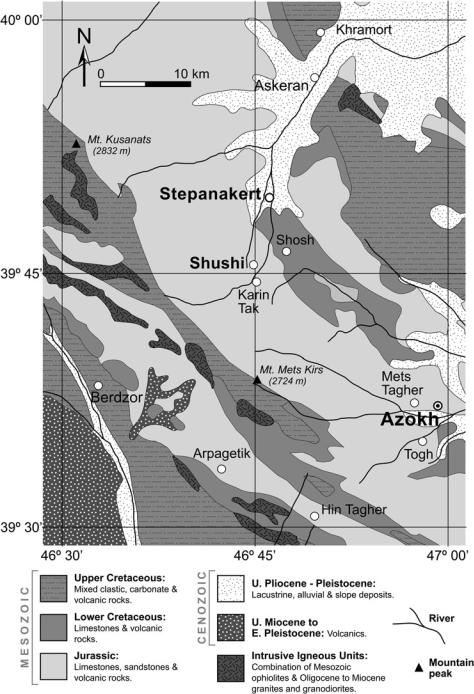
Fig. 3.2 Mesozoic to Cenozoic geology of the area surrounding Stepanakert and Azokh. Simplified from Vardanyan et al. (2010)
Marine fossils have been recovered from the limestone (Fig. 3.3a–c). Samples of silicified sponge and both open branching (dendroid) and massive scleractinian corals have been collected from outcrops in the vicinity of the cave. Very conspicuous Thalassinoides-type fossil burrows are evident in the bedrock at the main entranceway to Azokh Cave (Fig. 3.3d). This ichnofossil is characterized by a series of fairly large diameter tubes (20–40 mm at Azokh), which branch in a complex manner,
leading to development of a 3-dimensional network. These burrows typically form in reasonably shallow, open shelf settings. Crucially, the burrow network has been pervasively silicified (presumably due to the infilling sediment having a more favorable porosity for percolating silica-rich fluids), resulting in a strong interconnected barrier to karstic solution. In places along the cave wall where the host limestone has been dissolved away, sandy/silty cave-filling sediments are observed infilling the