

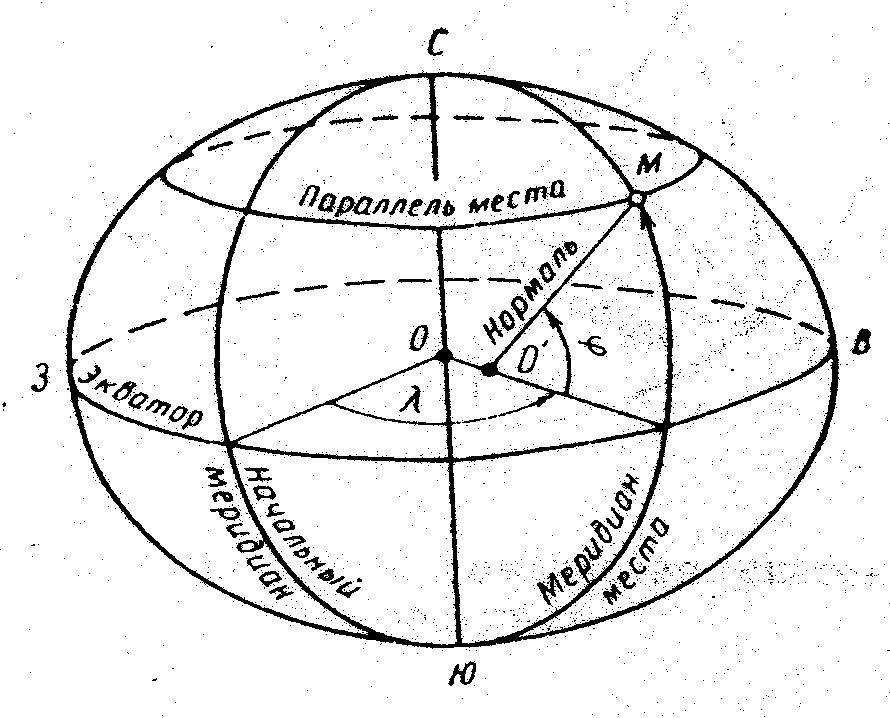
Координаты точки на поверхности сфероида (глобуса). Геодезические координаты.
Для определения положения точки на поверхности земного эллипсоида используются эллипсоидальные геодезические координаты точки
Геодезические координаты – это угловые величины, определяющие положение точки на поверхности земного эллипсоида. Координатами точки на эллипсоиде являются геодезическая широта (В) и геодезическая долгота (L).
Геодезической широтой (В) называется угол между плоскостью экватора и направлением нормали к поверхности эллипсоида в данной точке.
Нормаль - перпендикуляр к касательной плоскости, проведённой через заданную точку; не проходит через центр эллипсоида (кроме точки на полюсах и экваторе) является расчетным параметром.
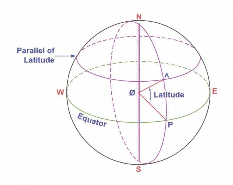
Meridians (large circle) - the line section of the surface of the Earth by a plane passing through the poles, they are called true or geographic meridians.
All points on the same meridian have the same longitude.
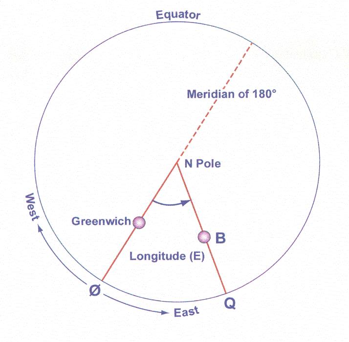
Meridian passing through astronomical observatory of Greenwich (near London), adopted by international agreement as the start and called Greenwich meridian (initial) and has a value of 0º longitude. Longitude reckoned eastward from the support - Greenwich to 180 ° is called the East and in the West to 180 ° - Western.
The prime meridian (Greenwich) divides the globe into two hemispheres Eastern (E) and West (W)
What are geometric shape cross-sectional plane of the meridian, and why?
Parallels and meridians form a grid coordinate depending on which figure it is located, formed geodetic, or spherical celestial coordinates.
3. Coordinates of points on the surface of the spheroid (globe). Geodetic coordinates.
To determine the position of a point on the surface of the earth ellipsoid used ellipsoidal geodetic coordinates of the point.
Geodetic coordinates - it's angular values, determining the position of a point on the surface of the earth ellipsoid. Coordinates of the point on the ellipsoid are the geodetic latitude (B) and geodetic longitude (L).
Geodetic latitude (B) is the angle between the plane of the equator and the direction normal to the surface of the ellipsoid at this point.
Normal is perpendicular to the tangent plane passing through a given point, does not pass through the center of the ellipsoid (except at the poles and the equator) is the basis for the calculation.
Широта измеряется в градусах, минутах секундах, или в долях минут.. Отсчет (начало отсчета) ведется от экватора к полюсам от 0 до 90. Широта отсчитываемая к северу, называется северной и считается положительной. Широта, отсчитываемая к югу, называется южной и считается отрицательной. На экваторе широта Оº на полюсах 90º. Все точки лежащие на одной параллели имеют одинаковую географическую широту.
Обозначение в сборниках с буквами N, S.
Пример: N 43 52.7 58º 24' 42 " S
|
|
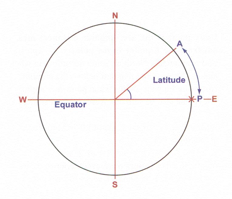
Можно ли измерить геодезическую широту дугой меридиана?
Геодезическую широту измерить дугой меридиана Нельзя, потому что поверхность эллипсоида в разных точках имеет разную кривизну.
Какова разница широт.
Latitude is measured in degrees, minutes, seconds, or fractions of minutes.
Count (the origin) is from the equator to the poles from 0° to 90°. Latitude counted toward the north, called the North and is considered positive. Latitude, measured to the south, called the South and is considered negative. At the equator the latitude 0º at the poles 90º. All the points lie on the same parallel have the same latitude.
Designation in the collections of the letters N, S.
Example: N 43 52.7 58 º 24 '42 "S

Is it possible to measure the geodetic latitude of the arc of the meridian?
Geodetic latitude measure the arc of the meridian can not, because the surface of the ellipsoid at different points have different curvatures.
What is the difference between latitudes.
|
1 |
2 |
3 |
4 |
|
Точка Х |
Вº |
40º00׳ N |
26º43׳ N |
40º00׳ N |
26º43׳ N |
Lº |
100º00E |
100º00E |
100º00E |
100º00 W |
|
Точка У |
Вº |
10º00 N |
34º22 N |
30º00 S |
34º22 S |
Lº |
100º00E |
100º00E |
100º00E |
100º00 W |
|
∆ Вº |
30º |
7º39 |
70º |
61º05 |
|
Геодезической долготой (L) называется двугранный угол между плоскостью начального (Гринвичского) меридиана и плоскостью меридиана данной точки М или длина дуги экватора, выраженная в градусах, между начальным меридианом и меридианом данной точки. Отсчет(начало отсчета) ведется от начального меридиана к востоку и западу от 0 до 180. Долгота отсчитываемая на восток, называется восточной и считается положительной. Долгота, отсчитываемая на запад, называется западной и считается отрицательной. Начальный меридиан, который проходит через Гринвич (Англия), является 0° долготы.
Отсчитывается в градусах, минутах секундах, или в долях минут.
Обозначение в сборниках с буквами W, E.
Пример: W 43 52.7 58º 24' 42 " E
|
|
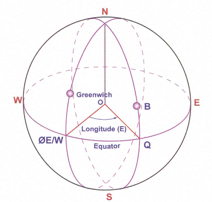
ВОПРОС: Можно ли выразить долготу центральным углом в соответствующих плоскостях экватора или параллели?
Можно, потому что экватор и параллель земного эллипсоида представляют собой окружности
Какова разница долгот.
|
1 |
2 |
3 |
4 |
|
Point Х |
Вº |
40º00׳ N |
26º43׳ N |
40º00׳ N |
26º43׳ N |
Lº |
100º00E |
100º00E |
100º00E |
100º00 W |
|
Point У |
Вº |
10º00 N |
34º22 N |
30º00 S |
34º22 S |
Lº |
100º00E |
100º00E |
100º00E |
100º00 W |
|
∆ Вº |
30º |
7º39 |
70º |
61º05 |
|
Geodetic longitude (L) is called a dihedral angle between the plane of the initial (Greenwich) meridian and the plane of the meridian of the point M, or the length of the arc of the equator, expressed in degrees, between the prime meridian and the meridian of the point. Count (the origin) is of the prime meridian east and west from 0° to 180°. Longitude reckoned to the east, called the East and is considered positive. Longitude, measured to the west is called the west and is considered negative. The prime meridian that runs through Greenwich (England) is 0° longitude.
Measured in degrees, minutes, seconds, or fractions of minutes.
Designation in the collections of the letters W, E.
Example: W 43 52.7 58 º 24 '42 "E
|
|
QUESTION: Is it possible to express longitude central angle corresponding to the equatorial plane or parallel?
It is possible, because the equator and parallel to the earth's ellipsoid are circles
What is the difference in longitude.
|
1 |
2 |
3 |
4 |
|
Точка Х |
Вº |
40º00׳ N |
40º00׳ N |
40º00׳ N |
40º00׳ S |
Lº |
030º42 E |
007º42 E |
070º00 E |
007º42 E |
|
Точка У |
Вº |
40º00 N |
40º00 N |
40º00 N |
40º00 S |
Lº |
070º00 E |
023º26 E |
030º00 W |
023º26 W |
|
∆ Lº |
40º00 |
15º44 |
100º00 |
31º08 |
|
Положение точек на земной поверхности относительно земного эллипсоида определяются по третьей координате, которая называется геодезической высотой, а сама система называется пространственной. Геодезическая высота определяет положение точки на земной поверхности относительно земного эллипсоида.