

Київський національний університет імені Тараса Шевченка
Геологічний факультет
Кафедра геології нафти і газу
Конспект лекцій
до
НАВЧАЛЬНОЇ ДИСЦИПЛІНИ
Course “Earth's Deep Underground Hydrosphere”
(ГЛИБИННА ГІДРОСФЕРА ЗЕМЛІ)
Лекція № 9
“Conceptualizing Groundwater Systems”.
для магістрів I курсу геологічного факультету
(спеціальності: геологія нафти і газу, гідрогеологія)
Київ-2013
Конспект лекцій навчальної дисципліни
Course “Earth's Deep Underground Hydrosphere”
для студентів геологічного факультету
Упорядник: доцент І.М. Байсарович
-2-
Theme 4. “Conceptualizing Groundwater Systems”.
Лекція № 9
Program:
Water table (the groundwater table);
Brittle-ductile transition;
Driving forces for groundwater flow.
Conceptualizing Groundwater Systems.
In the course of „Earth’s Deep Underground Hydrosphere” we are generally concerned with the depth range between the water table and the brittle-ductile transition in the midcrust (which might occur at approx.15 km depth in a region with a normal geothermal gradient).
Water table. The water table is defined as the surface where pressure in the liquid phase, Pw, is equivalent to atmospheric pressure, Patm (Figure 4.1). Below the water table Pw > Patm and, less obviously, above the water table Pw < Patm, because air and water coexist in the pore space. The air pressure above the water table Pair ~ Patm, requiring Pw < Patm in order to balance the surface tension acting along the curved air-water interfaces.
Under the most hydrogeologic conditions the water table is a subdued replica of the topography, as is shown schematically in Figure 4.1. Even under extreme conditions, depths to the water table from the land surface generally amount to < 500 m. Large excursions from the land surface may occur in regions of moderate to great topographic relief, high permeability, and or in arid climates. Most regional-scale groundwater flow is driven by variations in hydraulic head caused by topographic relief.
-3-
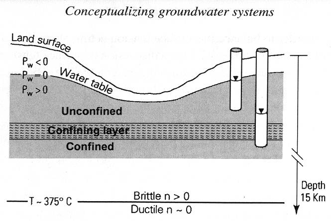
Figure 4.1 Schematic diagram of a hydrogeological system showing the domain of interest between the water table and the brittle-ductile transition and defining the water table and confined and unconfined groundwater systems. Below the brittle−ductile transition, ductile deformation presumably collapses porosity, so that n ~ 0.0.
As well drillers bore deeper into soil and rock, the samples they bring up become increasingly wet. At shallower depths, the material is unsaturated; that is, the pores contain some air and are not completely filled with water. This level is called the unsaturated zone. Below it is the saturated zone, the level in which the pores of the soil or rock are completely filled with water. The saturated and unsaturated zones can be in either unconsolidated material or bedrock (Figure 4.2). The boundary between the two zones is the groundwater table, usually shortened to the “water table». When a hole is drilled below water table, water from the saturated zone flows into the hole and fills it to the level of the water table.
-4-

Figure 4.2 The groundwater table is the boundary between the unsaturated zone and the saturated zone. The saturated and unsaturated zones can be in either unconsolidated material or bedrock.
Groundwater moves under the force of gravity, and so some of the water in the unsaturated zone may be on its way down to the water table. A fraction of the water, however, will remain in the unsaturated zone, held small pore spaces by surface tension, the attraction between the water molecules and the surfaces of the particles. Evaporation of water in pore spaces in the unsaturated zone is slowed both by the effect of surface tension and by the relative humidity of the air in the pore spaces − possibly close to 100 percent.
If we were to drill wells at several sites and measure the elevations of the water levels in the wells, we could construct a map of the water table. A cross section of the landscape might look like the one shown in Figure 4.3. The water table follows the general shape of the surface topography, but the slopes are gentler. The water table is at the surface in river and lakes beds and springs.
-5-

Figure 4.3 Dynamics of the groundwater table in permeable shallow formations in a temperate climate. Water enters the ground y infiltration of rain and melted snow and discharges at springs and rivers. The unsaturated zone varies in thickness as the water table rises in wet seasons and falls in dry seasons.
Under the influence of gravity, groundwater moves downhill from an area where water-table elevation is high − under a hill, for example − to places where the water-table elevation is low, such as a spring where groundwater exists to the surface.
The groundwater flow system immediately below the water table is an unconfined system, within which the total hydraulic head roughly coincides with the elevation of the top of the water-bearing unit. Less-permeable horizons below the water table act as confining layers, and the total hydraulic head h in the underlying confining systems is greater than the elevation at the base of the overlying confining layers (h = Pw/ρwg + z > z). The mathematical description of the unconfined groundwater systems is complicated by the fact that the water table acts as a moving upper boundary and by the fact that water flows cross this moving boundary in response to variable head gradients.
-6-
Another basic hydrogeologic concept is that the pore or voids space is saturated with (dominantly) aqueous fluids between the water table and midcrustal depths. Hydrogeologists tend to call these aqueous fluids “groundwater”, whereas geologists and geophysicists tend to call them simply “fluids”. With increasing depth there is in fact an increasing likelihood that the pore fluid will be dominated by something other than groundwater of recent meteoric origin, for example, by connate waters; metamorphic, magmatic, or mantle-derived fluids; or by hydrocarbons. However, regardless of the origin of the fluids, the “groundwater” theory is generally applicable so long as some form of Darcy’s law describes the flow.
A final basic assumption is that all nonductile geologic media have some finite ability to transmit water via Darcian flow. Since modern equipment has decreased the feasible measurement limit to perhaps 10-23 m2, nearly all geologic media have been shown to have finite permeability.