

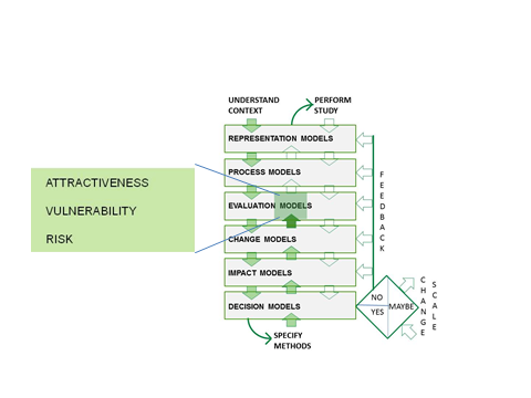
Evaluation models
The content of the evaluation models is derived from the decision models.They are based on the decision makers’ needs to assess the comparative impacts of the present state of the context geography together with its likely future state that may develop following any proposed design changes. The evaluation models will directly influence the change models by focusing the design on areas which need change as well as those which should be protected and conserved.
Questions for the evaluation models as they relate to the decision model include:
What are the measures of evaluation across distinct but relevant fields (ecology, development economics, visual preferences, politics, etc.)?
What are their spatial, temporal, qualitative and quantitative metrics?
Are they scientifically or judgmentally based?
Are they related to legal standards?
Criteria for evaluation
Geodesign relies heavily on evaluative criteria related to the geographical context of the study area. These can be conveniently grouped into three categories: site, location, and administration. Site derived criteria relate to the specific place being studied: its physical characteristics such as terrain, geology and ecology, and social characteristics such as the demographics of its people. Location derived criteria move beyond the exact location to the surrounding geography and include such spatial effects as whether it is influenced by upstream hydrology, upwind fire risks, ugly outward views, etc. Administrative criteria include such things as zoning and planning laws and regulations, and various property rights.
Evaluation criteria should be expressed as the answers to three questions:
What is important?
How is it important?
How important is it?
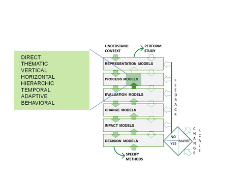
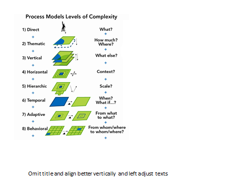
Process models
 Questions
for process models as they relate to and are linked with impact
models include the following:
Questions
for process models as they relate to and are linked with impact
models include the following:
Which models should be included?
How complex should the models be?
How shall the impacts be summarized and visualized?
Which processes models are beyond the modeling capabilities of the geodesign team?
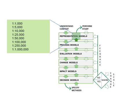
Representation models
During this second iteration through the framework, the geodesign study should be organized and specified to identify the minimumamount of data actually needed for the study. The aim then is to acquire, organize, and use only those data, avoiding the expense and effort of gathering and preparing any data unnecessary for the study. For this to occur, specifying the preceding decision, impact, change, evaluation and process models must happen first. In addition, the representation model and its visualization methods must also consider how change will be visualized.
Questions related to representation models include the following:
Which data are needed? For which geography? At what spatial scale? At which classification? For which times? From which sources? At which cost? In which mode of representation?
What are the appropriate data management technologies?
What are the appropriate visualization technologies?