

Page 23 of 23
A FRAMEWORK FOR GEODESIGN
Edited from
Steinitz, C, A Framework for Geodesign, Esri Press, 2012
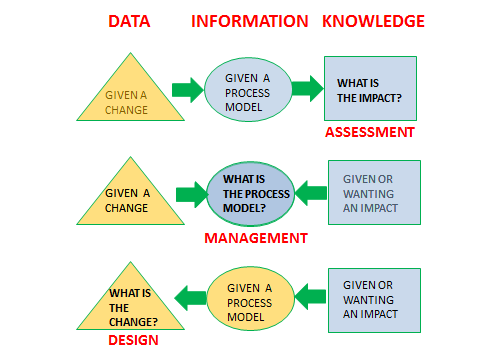
Assessment, management and design
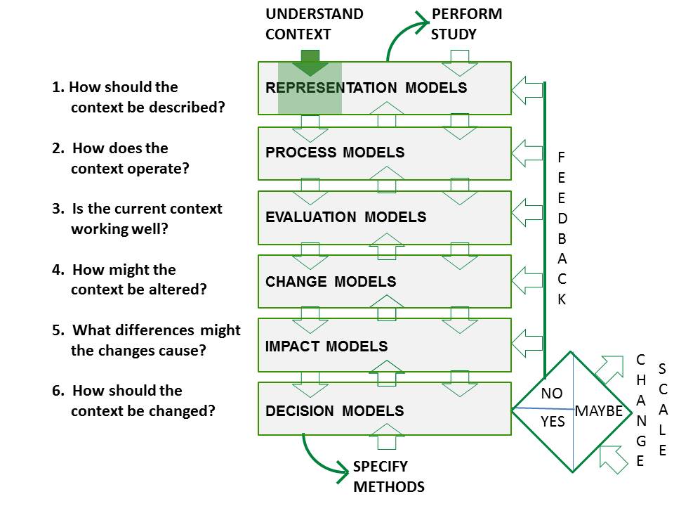
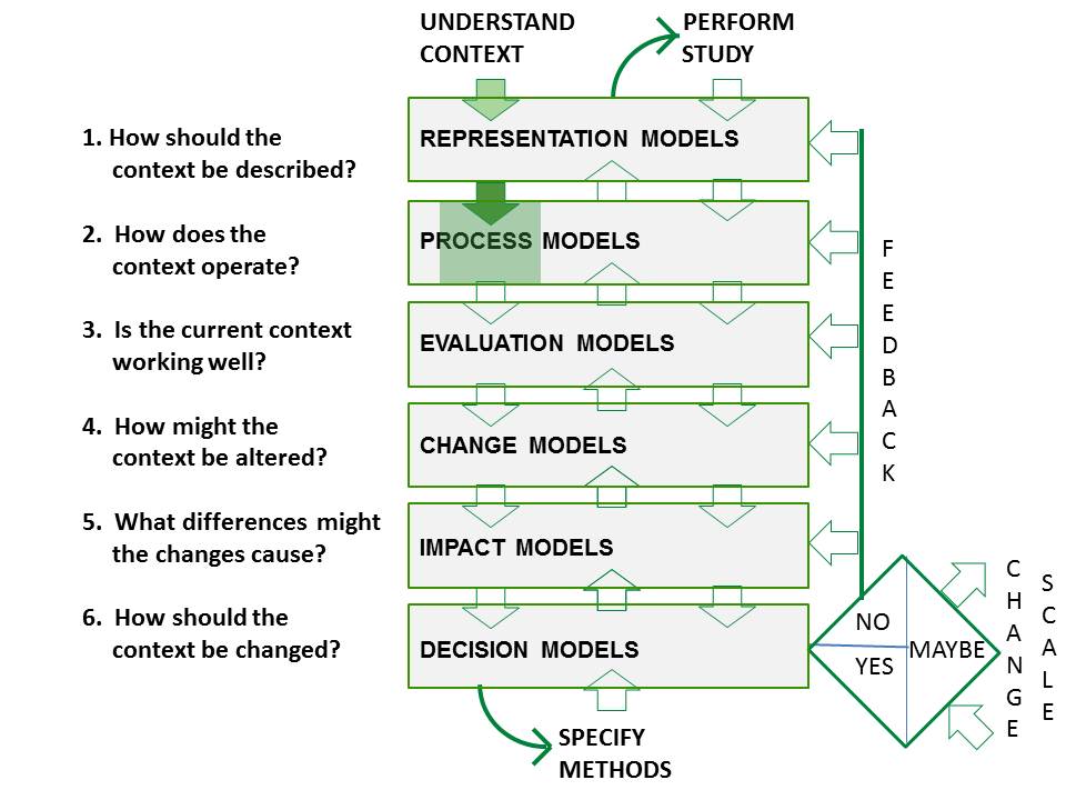
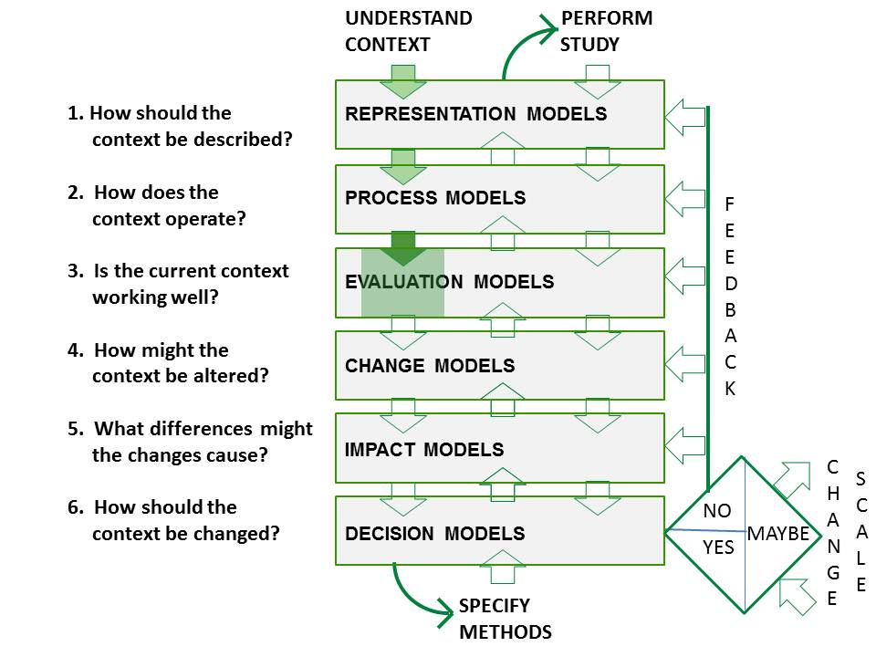
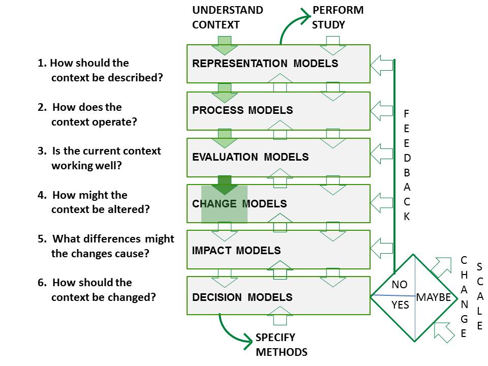
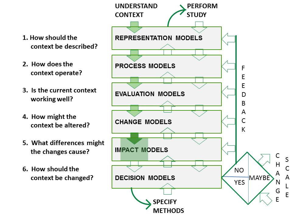
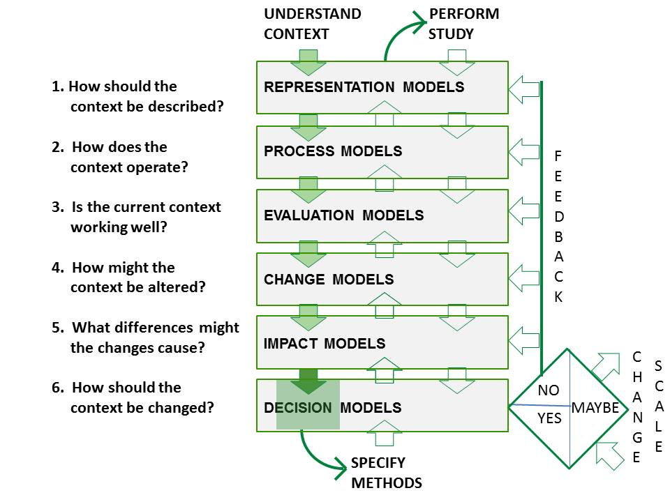
The six questions of the framework

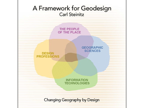
Thestakeholders, the geodesign team, and the framework forgeodesign
1. How should the study area be described in content, space, and time? This question is answered byrepresentation modelsthe data upon which the study relies.
2.How does the study area operate? What are the functional and structural relationships among its elements? This question is answered by process models, which provide information for the several assessment analyses of the study.
3.Is the current study areaworking well? This question is answered by evaluation modelswhich are dependent upon the cultural knowledge of the decision-making stakeholders.
4.How might the study area be altered? By what policies and actions, where and when? This question is answered by change models, which will be developed and compared in the geodesign study. These also generate datathat will be used to represent future conditions.
5.What difference might the changes cause? This question is answered by impact models, which are assessments produced by the process models under changed conditions.
6.How should the study area be changed? This question is answered by decision models, which, like the evaluation models, are dependent upon the cultural knowledge of the responsible decision makers.
The three iterations through the framework
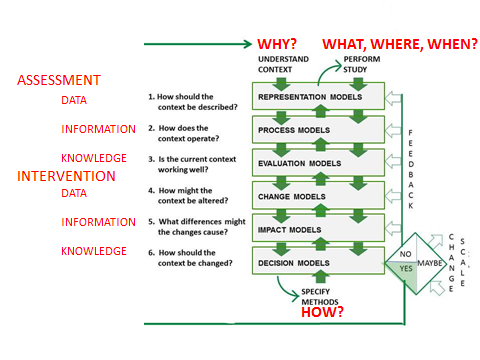
Over the course of the geodesign study, each of these six primary questions and their subsidiary questions are asked three times. In the first iteration through the sequence, they are asked rapidly, beginning with question 1 as it defines the context and scope of the work.In this first iteration we treat these as WHYquestions for the project.In the second iteration, the same six primary questions are asked in reverse order from 6 to 1. This identifies and defines the methods of study, the HOWquestions.And in the third iteration, they are asked again in the original order of 1 to 6 as we implement the study method and address the WHAT, WHERE, and WHENquestions.
It is important to emphasize that geodesign is not just proposing changes, as question 4 alone might suggest. Whether explicitly or implicitly, all six questionsmust be satisfied throughout all three iterations of the framework for a geodesign study to be complete. Decisions by the stakeholders may then lead to implementation of change.
The first iteration:
The WHYquestions
The objective of the first iterationis to understand the geographic study area and the scope of the study. So in this iteration, the six questions, asked in order from 1 to 6, are intended to answer WHYthe study is to happen.

Scoping the geodesign study:
Questions 1 through 6 and their related models:
1. How should the study area be described in content, space, and time?
Representation model questions might include the following:
Where are the boundaries of the study area’s major systems?
What is the area’s physical, economic, and social geography?
What is its physical, economic, and social history?
Are there prior plans and designs for this geographic study area?
Are there existing(digital) databases for the area? Are they accessible to the study team?
2. How does the study area operate?
Process model questions might include:
What are the area’s major physical, ecological and human geographical processes?
How are they linked to each other?
3. Is the current study area working well?
Evaluation model questions might include the following:
Is the area seen as attractive? Why? Why not?
Is the area seen as vulnerable? Why? Why not?
Are there current environmental and other “problems” in the area?
Are there groups with differing views on these questions?
4. How might the study area be altered?
Change model questions might include the following:
What major changes are foreseen for the region?
Are they related to growth or decline?
Are they related to development or conservation (or both)?
Are the pressures for change coming from the inside or outside?
5. What difference might the changes cause?
Impact model questions might include the following:
In which ways are foreseen changes seen as beneficial or harmful?
Are these impacts seen as serious? As irreversible?
6. How should the study area be changed?
Decision model questions might include the following:
Who are the major stakeholders? Are they from the public or private sector?
Are peoples’ “positions” known? Are they in conflict?
Which consequences of change are considered most important?
Are there other major concerns that would influence decisions about change?
What is the main purpose of the geodesign study? Public action? Economic profit? Scientific knowledge?
Are there legal and implementation-related aspects that must be considered?
Are there any binding limitations that must guide the activities of the geodesign study?
Scenarios of assumptions, objectives, and requirements
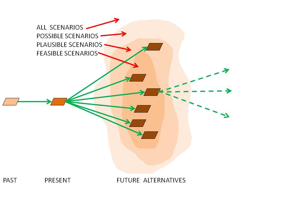
The activity of scoping a geodesign study involves the preliminary development of a scenario or scenarios. These are the assumptions, objectives, and requirements that will guide the design of the geodesign study methods, especially the change model(s). Preliminary scenarios should be concentrated as much as possible in the realm of reasonable combinations of policy and program assumptions, with the hope that they will later develop into feasible designs for the future.
Preliminary scope and budget
Meeting with stakeholders
At the end of the first iteration, the geodesign team should meet with the people of the place and those involved in making decisions, and share with them their understanding of the situation up to that point. Mutual trust between the team and the decision makers needs to be developed and evolving perceptions need to be shared. Everyone needs a common understanding of the intended scope of the study and a sense that the geodesign team can and will propose a competent and feasible methodological plan once they reach the end of the second iteration.
The second iteration:
TheHOWquestions
 The
aim of the second iteration is to choose and clearly define the
methods of the study, the HOWquestions.
In this stage, the framework is used in reverse order, working from
question 6 to question1.This reversal of the regular sequence of
conducting a study is crucial to designing a set of potentially
useful methods.In this way,geodesign becomes decision-driven rather
than data-driven.The
answers to this round of questions provide the geodesign team with an
agreed-upon methodology for the study
The
aim of the second iteration is to choose and clearly define the
methods of the study, the HOWquestions.
In this stage, the framework is used in reverse order, working from
question 6 to question1.This reversal of the regular sequence of
conducting a study is crucial to designing a set of potentially
useful methods.In this way,geodesign becomes decision-driven rather
than data-driven.The
answers to this round of questions provide the geodesign team with an
agreed-upon methodology for the study
Designing the study methodology:
Questions 6 through 1 and their related models:
The decision models require the impact models in order to assess the consequences of proposed changes. The several types of impact models and their needs for analytic complexity lead to the ways in which the change models and their resulting alternatives will be created and expressed. The change models require the evaluation models and their assessments of current and past conditions. These in turn need the process models for their understanding of the underlying functioning of the geographical context of the study. The process models require data, the ways that the study area is represented. This sequence will also influence the study’s methods and technologies for information management and visualization. When all of these models are defined and made operational, they become the methodology for the geodesign study