

IX Универ. геологич. чтения_сборник_2015
.pdfFig. 1 Ice movement during the Pripyat and Poozerye glaciations within western Belarus Legend: ice sheets and their boundaries: 1 – Sozh, 2 – Poozerye, 3 – ice divides in between
streams and lobes, 4 – ice sheds in between tongues. Directions of ice movement according to data of: 5 – erratic indicators, 6 – orientation of glacial exaration valleys, 7 – glacial structures and dislocations, 8 – textural elements of basal moraines, 9 – coarse-grained material of basal moraines. Ice streams: I – West Polesye, II – Neman, III – Riga. Glacial lobes: WP – West Polesye, UN – Upper Neman, O – Ozersk. Ice tongues of the Sozh Ice Sheet: VOL – Volkushansk, LOS – Lososna, SVI – Svisloch, ROS – Ross, ZEL – Zelva, SCHAR – Schara, MOL – Molchad; the same of the Poozerye Ice Sheet: MON – Monkovcy, BOG – Bogushevsk, ORL – Orlovsk, GAN – Ganelsk.
References
Matoshko А.V. Ehlers Ed., Gibbard J., P. L., Hughes P. D. Limits of the Pleistocene Glaciations in the Ukraine: A Closer Look // Quaternary Glaciations – Extent and Chronology. – Amsterdam, 2011. - P. 405−418.
Palaeogeography of Cenozoic of Belarus. Edited by A.V. Matveev. – Мinsk, 2002. - 164 p. (in Russ.).
Viiding H, Gaigalas A., Gudelis V., Raukas A., Tarvidas R. Crystalline indicator boulders in the East Baltic Area. - Vilnius, 1971. - 96 p.
170
UDC 567.43; 551.734.2 (476)
D. P. Plax
Belarusian National Technical University, Minsk, Belarus
LATE EMSIAN PLACODERMS OF BELARUS
Late Emsian placoderms of Belarus are well known from the published lists [Plaksa, 2007; Plax 2008a; 2008b]. However, the general information on their localities in the territory of the Republic, that is, in which particular borehole and at which depth exactly they were found, so far has hardly been given. This paper is aimed to fill in this gap. By now various skeleton elements of the Late Emsian placoderms are reliably discovered in eleven boreholes within the territory of Belarus. They are: Vilchitsy 1, Berdyzh 1, Rogachev 736, Bobruysk 691/2, Osipovichi 6, Bykhov 151, Chashniki 53, Lepel 1, Latvishi 12, Murovshchina 1 and Buda Dal’nyaya 35. The first reliable finding of the Late Emsian placoderm was made within the territory of the country more than fifty years ago. The skullcap, trunk shield, a number of separate plates from the trunk shield and endocranium of phlyctaeniid which subsequently received the species name Kartalaspis belarusica Mark-Kurik were discovered in deposits of the Vitebsk Regional Stage. The latter species has existed in literature as a nomen nudum for many years and is spelled in different ways (belorussica, byelorussica and belarussica) [Mark-Kurik, 2002]. This species is interesting in two aspects. Firstly, it was found in two distant localities, namely, in Eastern Belarus and Southeastern Estonia. In the territory of Belarus, Kartalaspis remains were found in the Vilchitsy 1 borehole in the Obol (depth 344.5 m) and Lepel (depth 327.6 m) beds of the Vitebsk Regional Stage of the Upper Emsian Substage of the Lower Devonian. In Southeastern Estonia, this species was found in deposits of the Rēzekne Formation of the Upper Emsian Substage of the Lower Devonian (Raigla 425 borehole, depth 272.2 m) [Mark-Kurik, 2002]. Secondly, it is the only phlyctaeniid from the Baltic area and Belarus with the endocrania preserved, even in two specimens.
During last ten years, the author found several more representatives of the Late Emsian placoderms. So, in the Osipovichi 6 borehole within deposits of the Lepel Beds of the Vitebsk Regional Stage the isolated small fragments of plates, fragment of the left anterior ventral plate, preorbital plates, fragment of the right paranuchal plate of cf. Diadsomaspis (depths 113.5 m, 113.8 m and 118.8 m) (Plate, Figs. 1, 2 and 3), fragment of the right paranuchal plate of Euarthrodira gen. indet. (depth 113.5 m) (Plate, Fig. 4), fragment of the left paranuchal plate of Actinolepididae gen. indet. (depth 113.8 m) (Plate, Fig. 5), small fragment plate of Ptyctodontida gen. indet. (depth 113.5 m) and the left mixilateral plate of Antiarcha gen. nov. Plax (depth 113.8 m) (Plate, Fig. 6) were found. Small fragments of plates of cf. Diadsomaspis were also found in the Bobruysk 691/2 borehole (depth 234.5 m). They were confined to deposits of the Lepel Beds of the Vitebsk Regional Stage. From the above mentioned taxa of fish, taxon cf. Diadsomaspis is the most interesting, because the plate fragment of this taxon was also found in the deposits of the Rēzekne Formation in the territory of
Lithuania (Liepkalnis 137 borehole, depth 631.2 m) [Mark-Kurik, 2002].
In deposits of the Lepel Beds of the Vitebsk Regional Stage in the Lepel 1 (depth 274.8 m), Bobruysk 691/2 (depth 233.0 m) and Bykhov 151 (depth range of 240,6-278.0 m) boreholes separate small fragments of plates of armor and small imprints of Phlyctaeniina gen. indet. were found. In the Rogachev 736 (depth 293.0 m) borehole within rocks of the Lepel Beds of the Vitebsk Regional Stage, several small and one large fragment of plate of Holonematidae gen. indet. (Plate, Fig. 7) were found. Small fragments of distal part plates of the pectoral fin of Antiarcha gen. indet. (depth 407.0 m) and isolated tubercles of Acanthothoraci gen. indet. (depth 410.0 m) were found in the Lepel Beds of the Vitebsk Regional Stage of the Berdyzh 1 borehole. In the Buda Dal'nyaya 35 (depth 233.2 m) borehole small fragments of posterior ventro-lateral plate, two anterior dorso-lateral plates of Coccosteidae gen. indet. (Plate, Figs. 8 and 9), which come from the Lepel Beds of the Vitebsk Regional Stage, were found. Interesting skeleton material on placoderms comes from deposits of the Lepel Beds of the Vitebsk Regional Stage of the Chashniki 53 (depth range of 291.0-294.4 m), Lepel 1 (depth 271.0 m) and Latvishi 12 (depth 254.0 m) boreholes. In these boreholes the left anterior lateral plate, the right interlateral plate, one anterior ventro-lateral plate and spinal plate of Ptyctodontida gen. nov. Plax (Plate, Figs. 10, 11 and 12) were found, as well as several fragments of plates which relative position on the body of the fish cannot be identified.
171

Plate – Placoderm plates from the Rogachev 732, Osipovichi
6, Buda Dal’nyaya 35, Lepel 1 and Chashniki 53 boreholes. The skeleton elements of placoderms from the Upper Emsian Substage, Lower Devonian. Scale bar of 8 сm for Fig. 7; 5 сm for Figs. 1, 4 and 5; 3.5 сm for Fig. 2; 3 сm for Fig. 11; 0.5 сm for Fig. 6; 0.4 сm for Fig. 10; 0.3 сm for Fig. 8; 0.25 сm for Fig. 3; 0.2 сm for Figs. 9 and 12:
Fig. 1 – cf. Diadsomaspis.
Specimen № 44/1-21. Osipovichi 6 borehole, depth 118.8 m, fragment of the right paranuchal plate in external view, Vitebsk Regional Stage, Lepel Beds.
Fig. 2 – cf. Diadsomaspis.
Specimen № 44/1-6. Osipovichi 6 borehole, depth 113.5 m, fragment of the left anterior ventral plate in external view, Vitebsk Regional Stage, Lepel Beds.
Fig. 3 – cf. Diadsomaspis.
Specimen № 44/1-6a. Osipovichi 6 borehole, depth 113.5 m, plate fragment in external view, Vitebsk Regional Stage, Lepel Beds.
Fig. 4 – Euarthrodira gen. indet. Specimen № 44/1-7a. Osipovichi 6 borehole, depth 113.5 m, fragment of the right paranuchal plate in external view, Vitebsk Regional Stage, Lepel Beds.
Fig. 5 – Actinolepididae gen. indet. Specimen № 44/2-1. Osipovichi 6 borehole, depth 113.8 m, fragment of the left paranuchal plate in external view, Vitebsk Regional Stage, Lepel Beds.
Fig. 6 – Antiarcha gen. nov. Plax. Specimen № 44/2-2. Osipovichi 6 borehole, depth 113.8 m, fragment of the left mixilateral plate in external view, Vitebsk Regional Stage, Lepel Beds.
Fig. 7 – Holonematidae gen. indet. Specimen № 6/1-1. Rogachev 736 borehole, depth 293.0 m, plate fragment in external view, Vitebsk Regional Stage, Lepel Beds.
Fig. 8 – Coccosteidae gen. indet. Specimen № 51/2-2a. Buda Dal’nyaya 35 borehole, depth 233.2 m, fragment of anterior dorso-lateral plate in internal view, Vitebsk Regional Stage, Lepel Beds.
Fig. 9 – Coccosteidae gen. indet. Specimen № 51/2-2. Buda Dal’nyaya 35 borehole, depth 233.2 m, fragment of the left anterior dorso-lateral plate in external view, Vitebsk Regional Stage, Lepel Beds. Fig. 10 - Ptyctodontida gen. nov. Plax. Specimen №43/16-1. Chashniki 53 borehole, depth range of 291.0-294.4 m, anterior ventro-lateral plate in external view, Vitebsk Regional Stage, Lepel Beds.
Fig. 11 - Ptyctodontida gen. nov. Plax. Specimen №43/16-2. Chashniki 53 borehole, depth range of 291.0-294.4 m, left anterior lateral plate in external view, Vitebsk Regional Stage, Lepel Beds.
Fig. 12 - Ptyctodontida gen. nov. Plax. Specimen №47/71-7. Lepel 1 borehole, depth 271.0 m, spinal plate in external view, Vitebsk Regional Stage, Lepel Beds.
According to J. Valiukevi ius, V. Karatajūtė-Talimaa and S. Kruchek [Valiukevicius et al., 1995) in the Mstislavl 1 (depth range of 491.0-523.0 m) borehole in deposits of the Lepel Beds of the
172
Vitebsk Regional Stage the species Millerosteus orvikui (Gross) was found. However, now this species is a junior synonym of Coccosteus cuspidatus Miller ex Agassiz, which comes from deposits of the
Upper Eifelian (for example, the Kostyukovichi Regional Stage of Belarus or the Kernavė Regional Substage of the Baltic States), and true genus Millerosteus is known from the Givetian Stage of the Middle Devonian. Taking into consideration this fact it is possible to conclude that they made a mistake, and the found skeleton material belongs to a different genus of placoderms.
In conclusion, it should be noted that the findings of skeleton elements of the Late Emsian placoderms listed here are very important for understanding of the completeness of ichthyofauna assemblages of the time interval under consideration. It is encouraging that all known in Belarus the Late Emsian placoderms are given as the open nomenclature, which makes it difficult to use them for the purposes of stratigraphy. It is related on the one hand with their insufficient studying, and on the other hand with fragmented and sporadic nature of findings of their skeleton elements. The studying of the Vitebsk deposits within the territory of the country is possible only in boreholes but deep drilling is currently very limited, due to the lack of funding. Thus, it is unreal to hope to find massive skeletal material. That is why it is necessary to study in more detailed way the available skeletal material, to reexamine the preserved palaeontologic collections of the Vitebsk Regional Stage in the tate Enterprise “Research and Production Center for Geology” so as to find there fish remains and purposefully explore the core material of those not yet liquidated cores of boreholes which expose the deposits of the Vitebsk Regional Stage. Then it is necessary to study in details and describe placoderms which skeleton elements are well represented, and to publish these results.
References
Plaksa D.P. Devonian (Late-Emsian – Frasnian) fish fauna of Belarus and its stratigraphic importance. – Candidate Thesis. Institute of Geochemistry and Geophysics of the National Academy of Sciences of Belarus. - Minsk, 2007. 23 p. (in Russian with Belarusian and English summary).
Plax D.P. Late Emsian ichthyofauna of Belarus // Geobiosphere events and the history of the organic world. Proc, of the LIV Session of the Palaeontological Society of the Russian Academy of Sciences (St. Petersburg, April, 7-11, 2008). – St. Petersburg, 2008a. – P. 136-137 (in Russ.).
Plax D.P. Devonian fish fauna of Belarus // Lithosphere. 2008b. – No. 2 (29). – P. 66-92 (in Russ.).
Mark-Kurik, E. Kartalaspis and other. Early Devonian arthrodires and their stratigraphic significance / The Fifth Baltic Stratigraphical Conference. Basin stratigraphy // Modern methods and problems. – Vilnius. 2002. - P. 117-119.
Valiukevičius J., Talimaa V., Kruchek S. Complexes of vertebrate microremains and correlation of terrigenous Devonian deposits of Belarus and adjacent territories / Ichthyolith Issues. Special Publication 1. Socorro, New Mexico, 1995. - P. 53-59.
УДК: 551.247 : 553.982.234
Siamak Mansouri-Far
Belarus State University, Minsk, Belarus
SALT DIAPIRS OF IRAN
Introduction. Six salt diapir provinces in Central Iran and very important diapir field in Zargos region have been studied earlier [Arian, 2012]. Diapir geological structures reveal the oil accumulation effect – trapping oil deposits around salt domes. The other economic importance is the possibility of the gas and oil underground storage in salt caverns within diapiric structures. The aim of this work is revising of main salt diapirs of Iran, suitable for gas and oil storages.
Geology. The main geological zones of Iran are: 1. Central Iran, 2. Sanandaj–Sirjan, 3. Zagros, 4. Alborz, 5. Azerbaijan, 6. Eastern Iran (Eastern Iran can be divided into two parts: Lut Block and Flysch or colored mélange of the Zabol–Baluch Zone), 7. Southeastern Iran (Makran), 8. Kopet Dagh [Ghorbani, 2013]. Iran is rich in salt deposits, and they are found in various forms such as subsurface salt domes, salines, and salt gulfs. Evaporite series from Precambrian to present have been identified in many parts of Iran, but there are two major salt horizons as described by Helmi [2000]. Zagros diapirs are deeper and placed within Hormuz Series (Cambrian formation), which mostly spread in
173
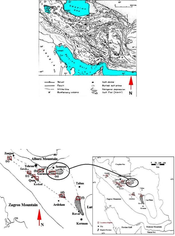
south of Iran. The other diapirs mostly locate within the Tertiary rocks in the Lower Red, Qom, and Upper Red Formations in Central Iran, Azerbaijan and eastern Iran (Fig. 1).
Fig.1. Map of salt domes and salines in Iran [Jackson, 1990]
Iran is the second largest holder of natural gas reserves in the world and producer of the clean energy in the region. Therefore, gas storages and gas operation management is the strategic task in the gas supplying in Iran [Salsabelie, 2011]. Generally, gas storage may be done in two ways: gas storages in porous rocks and in salt dome caverns. Gas storages in salt caverns show some advantages. It reveals the high gas flow rates, high injection capacity, complete gas recovery and some other features. That’s why salt diapirs are specific geological beds of great importance for the gas management.
Fig. 2. South Semnan diapiric province in Central Iran [Pourkermani,1997]
Results. There are 115 salt domes in south of Iran [Helmi, 2000], of which 101 are located between Bandar Abbas and Sarvestan and 14 in south of Kazerun, Fig. 2. Besides, within the saltbearing basin of Ardekan, salt domes outcrop in various shapes. As many as 80 salt domes have been
174
found in north of the desert near Ardekan–Yazd road including Namak-e Kalout, Haji Abad, and Rastagh in Yazd [Helmi, 2000]. Such deposits are also available in other parts of the country. There are many salt domes in Azerbaijan, and some of them are being exploited. Some examples of these salt domes are Douzkan, Alachigh, Khajeh, Shekarbolaghi, and Khoy-dou. There are also many salt domes along the Garmsar–Semnan axis, and some of these are of high purity [Helmi, 2000]. According to their argument, the sedimentary basin of Great Kavir is an intercontinental basin, which is filled with evaporate deposits, with a thickness of 6–7 km, from Eocene to the present. The Great Kavir basin has many salt domes; the highest concentration is located at the south side of the city of Semnan. At the west margin of this basin, there are two embayments of Qom and Garmsar (see Fig. 2); each of them is in the form of a basin with separate salt domes.
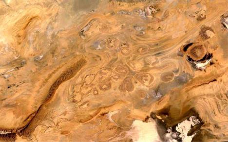
South of Semnan. More than 50 salt diapirs were defined in this area. Erosion has revealed 12 side-by-side diapirs (Fig. 3), and they look like dome-shaped roof. According to a group of researchers including [Gansser, 1955] and [Jackson, 1990], the salts observed in this region are of the new type. Moridi [1990] investigated salt domes at the southeastern side of Semnan interpreting their salt origin to the upper Eocene. The diapirism of this area can be assumed to have two separate origins [Arian, 2003].
The diapiric province of Great Kavir basin, south of Semnan can be considered the most extensive salt basin of Central Iran, because, based on previous studies, such as Jackson et al. [1990] and Arian, et al. [2003], there are old and new type of salt diapirs. In the Great Kavir penetration of interrelated diapirs with old and new salts occurs side by side or inside each other [Arian, 2004a].
Central Iran is a triangle zone that is bounded by Alborz and Zagros Mountains. According to age and geological setting of evaporitic deposits revealed by field work methods, diapiric provinces of Central Iran have been determined and parted. The location and general trend of the six diapiric provinces are mapped from border zones of Central Iran by investigation of ETM+ satellite images. Also, based on the shape and orientation, investigations of salt domes, tectonic processes (orogenic displacement) are predominant in comparison to halokinesis effects in Central Iran.
Fig. 3. Satellite image of the salt dome caprocks in the south Semnan (53,32 E & 34,57 N) [Google Earth]
Conclusions. Based on investigations of the shape and orientation of salt domes in Central Iran, six diapiric provinces have been introduced (see Fig. 2). These diapiric provinces include the Great Kavir, Garmsar, Qom, Kalot, Yengikand, and the Ravar basins. Salt diapirism within these provinces has orientations based on tectonic forces in foreland basins of the Central Iran. This effect is the consequence of the tectonic movement predomination in comparison with halokinesis of the salt rock beds. The salt diapirs shapes and orientations follow main structural trends in different basins of the Central Iran.
Acknowledgements. This work has been done at the Department of Dynamical geology, Belarusian State University, Minsk, Belarus. Also, special thanks for my supervisor Dr. Vladimir Samodurov for the help in the project fulfilling.
175
References
Arian M. (2012). Clusterring of diapiric provinces in the Central Iran basin. Carbonates Evaporites (2012) 27: 9–18 DOI 10. 1007/s13146-011-0079-9.
Arian M, Pourkermani M. (2004a). Structural significance of north Semnan and Attary Faults in Alborz-Central Iran border zone. J Sci Islamic Azad Univ 14(53): 4551–4569 (in Persian).
Arian M. (2003). Seismotectonic and earthquake-fault hazard investigations in the Kerman region. Research Institute of Applied Sciences.
Gansser A. (1955). New aspects of the geology in Central Iran. In: Proceeding of Forth World Petroleum Congress, Rome, pp 278–300.
Ghorbani M. (2013). The Economic geology of Iran. NewYork: Springer press.
Helmi F. (2000). A depiction of halite and, potash, and their distribution in Iran. Geological Survey of Iran, Tehran.
Jackson M.P.A., Cornelius R.R., Craig C.H. and others. Salt diapirs of the Great Kavir, Central Iran. Geological Society of America, USBN 0-8137-1177-0, 1990.
Moridi A.A. (1990). Diapirism investigation of salt domes in south Semnan. M. Sc. Dissertation, Structural Geology, Teacher Training University, Tehran Branch, pp 37–40 (in Persian).
Pourkermani M, Arian M. (1997). Salt domes of Central Iran. J Humanit Univ. Sistan Balouchestan 3(2): 29–41 (in Persian).
Salsabelie Mohamad, Brogerdie Abass, Sherkatie Shahram. (2011). Feasibility of natural gas storage in the central-northern Iran, No. 78. (in Persian).
Google Earth. (http://www.earth.google.com. Access on 20th February 2015).
176

СОДЕРЖАНИЕ |
|
|
|
Стр |
|
Предисловие |
3 |
|
Зуй В. И., Губин В. Н. , Санько А. Ф. , Ковхуто А.М., Мурашко Л. И. Вклад академика |
|
|
Г. В. Богомолова в изучение недр Беларуси |
4 |
|
Р.Е. Айзберг Геологические аспекты изучения «сланцевых» углеводородов |
8 |
|
Али А. А. Аль-Робай Стратиграфия и континентальный аллювий Ирака |
10 |
|
Балашов К. Ю., Мотузко А. Н. Геолого-геоморфологическая характеристика |
|
|
местонахождений ископаемой фауны млекопитающих на территории Жлобинского района |
11 |
|
Богомолов Ю. Г., Станкевич Р. А. Открытие и использование минеральных вод в г.Минске |
14 |
|
Василёнок Е. А. Прогнозирование нефтеносных структур в пределах Гировской площади |
|
|
Припятского прогиба по данным сейсморазведки |
18 |
|
Волчек А. А. , Шешко Н. Н. Изменения уровенного режима грунтовых вод территории |
|
|
национального парка «Беловежская пуща» |
20 |
|
Воронкова Н. Ф. Экономико-географические аспекты развития минерально-сырьевой базы |
|
|
Беларуси |
23 |
|
Галкин А. Н., Жогло В. Г. Об управлении литотехническими системами и его инженерно- |
|
|
геологическом обосновании |
25 |
|
Голованова И. В. , Сальманова Р. Ю. Учёт искажающего влияния палеоклимата при оценке |
|
|
температур глубоких горизонтов западной части Республики Башкиртостан |
28 |
|
Грибик Я. Г., Зуй В. И., Сусленко А. Л. Опыт создания теплообменников в скважинах |
|
|
Людвинковская 1т и Ново-Ельская 43т Припятского прогиба |
30 |
|
Губин В. Н. Активные геодинамические зоны и их инженерно-геологическое значение |
34 |
|
Губин В. Н., Кузьмин В. Н., Зуй С. И. Цифровая модель разломно-тектонической кинематики в |
|
|
рамках стандарта NADM-C1 |
37 |
|
Демежко Д. Ю., Горностаева А. А., Коноплин А. Д., Глазачев И. В. Тепловая активность |
|
|
горных пород как петрофизический параметр: измерение и приложения в науках о Земле |
40 |
|
Дзям’яненка М. А., Бабкоу В. Я. Інжынрна-геалагічныя ўмовы будаўніцтва буларуска- |
|
|
кітайскага індустрыяльнага парка |
42 |
|
Дубаневич М. А. Анализ изменений уровенного режима подземных вод в нарушенных |
|
|
эксплуатацией условиях на водозаборах г. Минска в период 2000–2013 гг. |
44 |
|
Жидкова Т. А. Индикация литологического состава четвертичных отложений и уровней |
|
|
залегания грунтовых вод Гродненской возвышенности и Средненеманской низины на основе |
|
|
использования космической информацией |
47 |
|
Жогло В. Г., Будник Н. И., Махнач А. А., Грибик Я. Г. О влиянии галитовой минерализации |
|
|
продуктивных отложений на особенности разработки залежей нефти I и IV блоков |
|
|
Березинского месторождения в Припятском прогибе |
49 |
|
Ильин В. П., Бабец М. А., Зуй В. И. Высокоточная термометрия для измерений в скважинах |
52 |
|
Карабанов А. К., Лопух П. С., Гледко Ю. А. Проблемы оценки ресурсов пресных подземных |
|
|
вод на территории Беларуси |
54 |
|
Карабанов А. К. , Богдасаров М. А. , Рылова Т. Б. , Моисеенко В. Ф. О возрасте дочетвертичных |
|
|
отложений, вскрытых скважиной «Свищево» в Каменецком районе Брестской области |
57 |
|
Карабанов А. К., Богдасаров М. А., Рылова Т. Б., Литвинюк Г. И. Новые данные о геологическом |
|
|
строении четвертичных отложений в опорном разрезе «Речица» Березовского района Брестской |
60 |
|
области |
||
|
||
Колошич С.М. Структура и происхождение камовых террас ледниковых ложбин |
|
|
Свентянских гряд |
62 |
|
Колпашников Г. А. , Смирнова Г. Ф., Литвинович К. Р., Шкода В. И. Значение изучения курса |
|
|
«Инженерная геология» в ВУЗах |
65 |
177
Коробейников Б. И. Оценка рисков и методы мониторинга подземных вод в пределах экологоопасных промышленных объектов Кручек С. А., Саченко Т. Ф., Обуховская В. Ю. Об ордовикских отложениях опорной
скважины Островец 1 (Северо-западная часть Беларуси)
Кудрявцева К. В. Гидрогеохимическая характеристика антропогенного загрязнения подземных вод водозабора «Новинки» Кузьмин С. И.,. Демидов А.Л, Зубрицкий В.С. Оценка воздейставия полигонов захоронения
отходов потребления на подземные воды (на примере Минской области)
Кутырло В. Э., Самодуров В. П. Программа расчётов истинной мощности рудного горизонта при бурении под углом к простиранию
Лаптёнок С. А., Левданская В. А., Карпинская Е. В., Минченко Е. М., Лазар И. В., Дубина М. А.
Оценка воздействия геодинамических процессов на показатели заболеваемости злокачественными новообразованиями методом расчёта коэффициентов конкордации
Лаптёнок С. А., Морзак Г. И., Хорева С. А., Гордеева Л. Н., Минченко Е. М.,
Осипов А. В. Пространственная корреляция динамики литосферы и показателей онкологической заболеваемости
Лаухин С.А., Санько А.Ф., Ларин С.И., Максимов Ф.Е. Межстадиал сартанского криохрона
(МИС-2) Иртыш-Ишимского междуречья по данным фауны моллюсков Левашкевич В. Г. , Глаз А. С. Температурные аномалии в скважинах подземных хранилищ газа
Лукашёв О. В. , Жуковская Н. В. , Лукашёва Н. Г. Структура базы данных химического загрязнения рек и озёр Беларуси
Мамчик С. О., Кручек С. А., Каримова Л. А., Клименко З. М. О составлении легенды для геологической карты дочетвертичных отложений территории Беларуси Матвеев А.В. Геоактивные зоны на территории Беларуси и их влияние на геоэкологическую обстановку
Махнач В. В. Корреляция келловей-оксфордских отложений по аммонитовым зонам в пределах северной части Припятского прогиба Москалев О. М. , Голушко Д. И. Ураноносность пород Белорусского кристаллического массива
Москалев О. М. , Даниленко В. В. О состоянии изученности Припятского прогиба на урановое сырье Мурашко Л. И. , Мурашко О. В. Голоценовые отложения учебного полигона геостанции
«Западная Березина» Мурашко Л. И. Полезные ископаемые палеогеновой системы Беларуси
Мякота В. Г. Распространение опасных геологических процессов в пределах трасс магистральных трубопроводов Беларуси Огар Дж. Ловушки и коллекторы нефтяных месторождений дельты Нигера и Припятского прогиба
Оношко М. П., Глаз А. С. Эколого-геохимическая карта территории 30-км Зоны влияния Островецкой АЭС Павловский А. И. , Галкин А. Н. Техногенные грунты на территории Гомеля
Петрова Н. С. Калийный рудогенез хлоридного типа в Припятском внутриконтинентальном рифте: процессы и механизмы Петрова Н. С., Денисова Н. Ю., Шакуля М. И. Сопряженный анализ осадочного выполнения и
развития тектонических структур в период формирования калиеносной субформации в центральной зоне Припятского палеорифта Петрова Н. С., Денисова Н. Ю. Изотопные равновесия в отложениях средневерхнефаменской
соленосной формации краевой северо-западной зоны Припятского прогиба Т. Б. Рылова, И. Е. Савченко Реконструкция палеотемператур стадиалов и интерстадиалов раннепротерозойского времени
66
69
72
74
76
78
81
83
85
88
92
95
98
100
102
104
107
109
111
114
118
120
122
125
128
178
Самодуров В. П., В. Э. Кутырло, Витовец В. А. Строение, состав и ритмичность |
|
формирования первого калийного горизонта Старобинского месторождения калийных солей |
|
по данным цифрового анализа керна скважин |
130 |
Самодуров В. П., Шутин С. Г., Мансури-Фар С. Моделирование динамики движения рассолов |
|
в камерах подземного растворения солей |
133 |
Санько А. Ф., Ярцев В. И., Дубман А. В. Литофациальный анализ в комплексе инженерно- |
|
геологических изысканий |
136 |
Сенько А. Н. Руководящие валуны ложбины оз. Долгое |
138 |
Сивенков А. Ю. Геоморфологические индикаторы проявления процессов поверхностного |
|
соляного карста в пределах солеотвалов Солигорского горно-промышленного района на |
|
основе космической информации |
140 |
Творонович-Севрук Д. Л., Лукашёв О. В. Распределение mn, Ni, Co, Cr в аллювии реки |
|
р. Птичь и ее притоков в п.г.т. Глуск |
142 |
Творонович-Севрук Д. Л. Особенности распределения растворённых Cu и Zn в речных водах |
|
Беларуси в период 1991─2008 гг. |
143 |
Трацевская Е. Ю. К вопросу о деформационных свойствах трёхфазных слабосвязанных |
|
грунтров в условиях динамического нагружения |
146 |
Унукович А.В., Краковецкий А.В. Экономическая ценность месторождений полезных |
|
ископаемых в системе устойчивого развития |
149 |
Хилькевич Е. В. Инженерно-геологические условия ледниковых ложбин Беларуси |
151 |
Чертко Н. К. Геохимия четвертичных отложений Беларуси |
153 |
Шершнев О. В. , Прилуцкий И. О. Уточнение геолого-гидрогеологических условий в пределах |
|
действующей сети мониторинга подземных вод промышленного объекта |
155 |
Шидловская А.В. История становления современной систематики минералов |
157 |
Юдаев С. А. Геологические критерии разведки и прогнозирования строительно-сульфатного |
|
сырья Беларуси |
160 |
Юдаев С. А. , Шидловская А. В. Благородные металлы в коренных и рыхлых отложениях |
|
Беларуси |
162 |
Якубовская Т. В., Литвинюк Г. И. , Моисеенко В. Ф. Новая граница между неогеном и |
|
квартером на территории Беларуси |
166 |
Mikhail Komarovsky, Katherina Khilkevich Ice-Flow direction vjvements of the Pripyat and |
|
Poozerye glaciations within Western Belarus |
168 |
Plax D. P. Late Emsian placoderms of Belarus |
171 |
Siamak Mansouri-Far Salt diapirs of Iran |
173 |
Содержание |
177 |
179