
- •Section 1: System Overview
- •1.1 PFD/MFD Controls
- •1.2 PFD Softkeys
- •1.3 MFD Softkeys
- •1.4 MFD Page Groups
- •1.5 Backlighting
- •1.6 XM Radio - Automatic Muting
- •Section 2: Flight Instruments
- •2.1 Airspeed Indicator
- •Speed Indication
- •Speed Ranges
- •Airspeed Trend Vector
- •Vspeed References
- •2.2 Attitude Indicator
- •2.3 Altimeter
- •Altitude Reference Bug
- •Altitude Trend Vector
- •Barometric Setting Box
- •2.4 Vertical Deviation/Glideslope Indicator
- •2.5 Marker Beacon Annunciations
- •2.6 Vertical Speed Indicator
- •2.7 Horizontal Situation Indicator (HSI)
- •Course Pointer
- •Course Deviation Indicator (CDI)
- •Bearing Pointers and Information Windows
- •Navigation Source
- •3.1 Engine Display
- •3.2 Lean Engine Display
- •3.3 Engine System Display
- •4.1 Radio Status Indications
- •4.2 Volume
- •4.3 Automatic Squelch
- •4.4 Quickly Activating 121.500 MHz
- •4.5 Optional NAV Radios
- •DME Radio (optional)
- •ADF Radio (optional)
- •Auto-tuning on the PFD
- •Auto-tuning on the MFD
- •4.7 Transponder
- •Mode Selection
- •Ground Mode (Automatic)
- •Reply Status
- •Code Selection
- •Flight ID Reporting
- •5.1 COM Radio Selection
- •5.2 Marker Beacon Receiver
- •Marker Beacon Signal Sensitivity
- •5.3 Nav Radio Audio Selection
- •5.4 Intercom System (ICS) Isolation
- •5.5 Intercom Squelch Control
- •5.6 Digital Clearance Recorder with Playback Capability
- •Section 7: Navigation
- •7.1 Navigation Map Page
- •Select the MAP Page Group
- •Direct-to Navigation from the MFD
- •Direct-to Navigation from the PFD
- •7.3 Airport Information
- •Select the Airport Information Page
- •Enter a Waypoint Facility Name or City Location:
- •Access Runway Information
- •Access Frequency Information
- •7.4 Intersection Information
- •Select the Intersection Information Page
- •Access Information on an Intersection
- •7.5 NDB Information
- •Select the NDB Information Page
- •7.6 VOR Information
- •Select the VOR Information Page
- •Access Information on a VOR:
- •7.7 User Waypoint Information Page
- •7.8 Nearest Airports
- •Nearest Airport Information on the MFD
- •Nearest Airports Information on the PFD
- •7.9 Nearest Intersections
- •Select the Nearest Intersections Page
- •View Information on the Nearest Intersection
- •7.10 Nearest NDB
- •Select the Nearest NDB Page
- •7.11 Nearest VOR
- •Select the Nearest VOR Page
- •View Information on the Nearest VOR:
- •Select and Load a VOR Frequency
- •7.12 Nearest User Waypoint
- •Select the Nearest User Waypoint Page
- •Select a Nearest User Waypoint
- •7.13 Nearest Frequencies
- •Select the Nearest Frequencies Page
- •7.14 Nearest Airspaces
- •Select the Nearest Airspaces Page
- •Airspace Alerts Box
- •View Additional Details for a Listed Airspace
- •View and Quickly Load the Frequency for a Controlling Agency
- •Section 8: Flight Planning
- •8.1 User Defined Waypoints
- •Select the User WPT Information Page
- •Create a New User Waypoint
- •Create User Waypoints from the Navigation Map Page
- •Modify a User Waypoint
- •Delete a User Waypoint
- •8.2 Viewing the Active Flight Plan
- •8.3 Activate a Stored Flight Plan
- •8.4 Activate a Flight Plan Leg
- •8.5 Stop Navigating a Flight Plan
- •8.6 Invert Active Flight Plan
- •8.7 Create a New Flight Plan
- •8.8 Load a Departure
- •8.9 Load an Arrival
- •8.10 Load an Approach
- •8.12 Store a Flight Plan
- •8.13 Edit a Stored Flight Plan
- •8.14 Delete a Waypoint from the Flight Plan
- •8.15 Invert and activate a Stored Flight Plan
- •8.16 Copy a Flight Plan
- •8.17 Delete a Flight Plan
- •8.18 Graphical Flight Plan Creation
- •8.19 Trip Planning
- •8.20 Vertical Navigation (VNAV) Page
- •VNAV Page Menu Options
- •Section 9: Procedures
- •9.1 Arrivals and Departures
- •Load and Activate a Departure Procedure
- •Load and Activate an Arrival Procedure
- •9.2 Approaches
- •Load and/or Activate an Approach Procedure
- •Activate An Approach in the Active Flight Plan
- •Section 10: Hazard Avoidance
- •10.1 Customizing the Hazard Displays on the Navigation Map
- •10.2 STORMSCOPE® (Optional)
- •Displaying Stormscope Lightning Data on the Navigation Map Page
- •Stormscope Page
- •10.3 XM Weather (Service Optional)
- •Displaying METAR and TAF information on the Airport Information Page
- •Displaying Weather on the Weather Data Link Page
- •NEXRAD Limitations
- •Weather Products & Symbols
- •Weather Product Age
- •10.4 Traffic Information Service (TIS)
- •TIS Audio Alert
- •10.5 Traffic Advisory System (TAS) (Optional)
- •System Self Test
- •10.6 Terrain And Obstacle Proximity
- •Displaying Terrain and Obstacles on the Terrain Proximity Page
- •Displaying Terrain and Obstacles on the Navigation Map
- •10.7 Terrain awareness & Warning system (TAWs) Display (Optional)
- •Displaying Terrain on the TAWS Page
- •Enable/Disable Aviation Data
- •TAWS Inhibit
- •Manual System Test
- •Forward Looking Terrain Avoidance (FLTA)
- •Reduced Required Terrain Clearance (RTC) and Reduced Required Obstacle Clearance (ROC)
- •Imminent Terrain Impact (ITI) and Imminent Obstacle Impact (IOI)
- •Premature Descent Alert (PDA)
- •Excessive Descent Rate Alert (EDR)
- •Displaying Terrain and Obstacles on the Navigation Map
- •Pop-up Alerts
- •TAWS Alerts Summary
- •Alert Annunciations
- •11.1 Reversionary Mode
- •11.2 Abnormal COM Operation
- •11.3 Unusual Attitudes
- •11.4 Stormscope operation with loss of Heading Input
- •12.1 Alert Level Definitions
- •12.2 NAV III Aircraft Alerts
- •WARNING Alerts
- •CAUTION Alerts
- •12.3 CO Guardian Messages
- •12.4 TAWS Alerts
- •12.5 G1000 System Annunciations
- •12.6 G1000 System Message Advisories
- •MFD & PFD Message Advisories
- •Database Message Advisories
- •GMA 1347 Message Advisories
- •GIA 63 Message Advisories
- •GEA 71 Message Advisories
- •GTX 33 Message Advisories
- •GRS 77 Message Advisories
- •GMU 44 Message Advisories
- •GDL 69 Message Advisories
- •GDC 74A Message Advisories
- •Miscellaneous Message Advisories
- •Index

SECTION 9: PROCEDURES
9.1ARRIVALS AND DEPARTURES
Load and Activate a Departure Procedure
1.With the Navigation Map Page displayed,press the FPL key.
2.Press the LDDP softkey. If a flight plan is active, the departure airport will be displayed as the default. A list of available departures is also displayed.
3.If no flight plan is active,use the FMS knobs to enter the identifier of the desired airport. Press the ENT key.
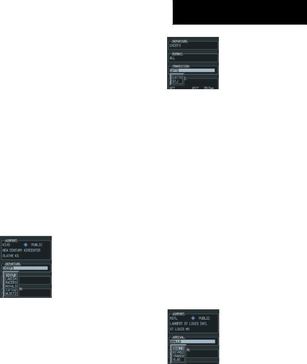
4.Turn the largeFMS knob to highlight the Departure field. Turn the small FMS knob to display a list of available departures.
5.Turn either FMS knob to select the desired departure and press the ENT key.
Figure 9-1 Select Departure
6.A list of runways may be displayed for the departure. Turn either FMS knob to select the desired runway and press the ENT key.
7.A list of available transitions is displayed for the departure. Turn either FMS knob to highlight the desired transition waypoint and press the ENT key.
SECTION 9 – PROCEDURES
Figure 9-2 Select Departure Transition
8.With ‘LOAD?’ highlighted, press the ENT key. The departure will be active when the flight plan is active.
Load and Activate an Arrival Procedure
1.With the Navigation Map Page displayed,press the FPL key.
2.Press the LD STAR softkey. If a flight plan is active,the destination airport will be displayed as the default. A list of available arrivals is also displayed.
3.If no flight plan is active,use the FMS knobs to enter the identifier of the desired airport. Press the ENT key.
4.Turn the largeFMS knob to highlight theArrival field. Turn the small FMS knob to display a list of available arrivals.
5.Turn either FMS knob to select the desired arrival and press the ENT key.
Figure 9-3 Select Arrival
Garmin G1000 Cockpit Reference Guide for the Cessna Nav III |
9-1 |