

Traffic calming
Traffic calming is the term used to describe physical features provided along a road to encourage drivers to reduce speed. These features are introduced for the safety of all road users, particularly pedestrians and cyclists. Traffic calming schemes can employ a variety of measures, including road humps and narrowings. Warning signs often indicate the type of measure to be expected. There may be an entry sign at the boundary of an area that has traffic calming features.
Entrance to a traffic-calmed area. The name of the area may be shown. The sign may also be used in advance of the area and show a distance. Where the traffic-calmed area is reached by turning into a side road, the sign will include an arrow
Road humps
Road humps may have a flat or round top, extending across the width of the road or covering a whole junction. They may also be in the form of a “cushion”, covering only part of a traffic lane and designed to allow buses and large emergency vehicles to straddle them, whilst slowing other vehicles. Except in a 20 mph zone, warning signs are erected at the beginning of the road where a hump or series of humps is installed.
Alternative plates used with "road hump" sign
|
|
|
|
Road humps for |
Road humps for |
Road hump for |
|
distance shown. |
distance shown |
distance shown |
|
May be varied to |
and in direction |
and in direction |
|
“Hump” with |
indicated |
indicated |
|
distance omitted |
|
|
|
72
traffic calming
A road hump is normally marked with white triangle and edge line markings.
Zebra and |
|
|
|
|
|
signal controlled |
|
|
|
|
|
pedestrian crossings |
|
|
|
|
|
are sometimes |
|
|
|
|
|
located on flat top |
|
|
|
|
|
humps. These may |
|
|
|
|
|
|
|
|
|
||
|
|
|
|
||
be indicated by |
Zebra crossing |
Signal-controlled |
|||
advance warning |
|||||
on a road hump |
pedestrian crossing |
||||
signs. |
|||||
|
|
on a road hump |
|||
Road narrowings
Roads may be reduced in width by the use of build outs on one or both sides. When placed on both sides, they may be opposite each other or staggered. Priority through the narrowing may be controlled by signs and “give way” markings. It is essential that you obey signs
indicating priority
to vehicles coming from the opposite
direction.
73

If priority is not given to either direction at a road narrowing, you should ensure that you can pass through without endangering occupants in vehicles approaching from the other direction. Do not accelerate on the approach to a narrowing, but maintain a slow steady speed and be prepared to give way to approaching traffic. Let any cyclists proceed ahead of you.
Road narrows |
Road narrows |
on left (right if |
on both sides |
symbol reversed) |
|
Warning signs indicating which side the narrowing occurs may be used in advance, especially where priority signs and markings are not provided.
Entrance to a Home Zone
Home Zones are residential areas with streets designed to be places for people as well as for motor traffic. The road space is shared
among drivers and other road users. People could be using
74
traffic calming
the whole of the space for a range of activities. You should drive slowly and carefully and be prepared to stop to allow people extra time to make room
for you to pass them in safety. 


 End of Home Zone
Quiet Lanes
Some minor rural roads may be designated as Quiet Lanes. These are appropriate for shared use by walkers, cyclists, horse
|
|
|
|
|
riders and motor |
|
|
|
|
|
vehicles. You should |
|
|
|
|
|
drive slowly and carefully |
|
|
|
|
|
and be prepared to stop |
|
|
|
|
|
to allow people extra |
|
|
|
|
|
time to make room for |
|
|
|
|
|
you to pass them in |
|
|
|
|
|
|
|
|
|
|
|
safety. |
|
|
|
|||
|
|
|
|||
Start of designated |
End of Quiet |
||||
Quiet Lane |
|
|
Lane |
||
Other features
Rumble devices across the road, either in the form of strips or larger areas, may be used to provide a visual, audible and vibratory effect, often in rural locations. The intention is to alert drivers to a hazard ahead, usually a bend or road junction, and encourage them to
reduce speed. A warning sign may be used in association with a rumble device to identify the hazard, but the device itself is not the hazard and is not usually specifically signed.
75
Gateways into villages may be formed from the combination of speed limit signs, yellow backing boards and village name plates. Central hatched markings or islands may also be used to separate opposing traffic. Drivers approaching the gateways should reduce speed and observe the speed limit all the way through the village.
Example of a village gateway
Some parts of the carriageway may have a coloured surface to emphasise the road markings.
76
motorway signs, signals and road markings
Motorway signs, signals and road markings
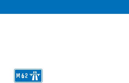
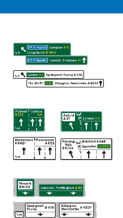
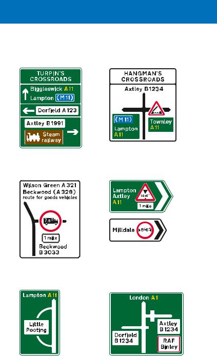
Most motorway signs have a blue background with white lettering, numbers and borders, although tourist destination signs, as on other roads, have brown backgrounds (see page 84).
Special traffic regulations govern the use of motorways. These include no stopping
(except, in an emergency, on the hard shoulder or verge), no U turns and no reversing. Goods vehicles and buses (where a bus is a vehicle constructed to
carry more than eight seated passengers) with a maximum laden weight of more than 7.5 tonnes, vehicles drawing trailers, and vehicles required to be fitted with a speed limiter, must not use the right hand lane of a motorway that has three or more lanes. Motorways must not be used by certain classes of traffic: learner drivers other than HGV, invalid carriages of less than 254 kg unladen weight, pedal cycles, motorcycles under 50 cc capacity, agricultural vehicles and vehicles incapable of attaining a speed of 25 mph on the level when unladen and not drawing a trailer. Pedestrians and animals are also prohibited.
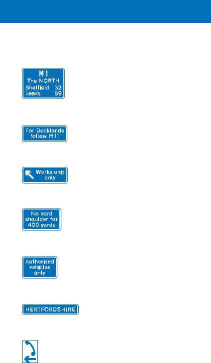
To ensure that direction signs are absolutely clear to drivers travelling at motorway speeds, it is necessary to limit the number of destinations shown. Your destination might not appear on the motorway signs: when planning a journey, it is advisable before setting off to check the junction number of the exit you require. Junctions can be identified by the number shown on a black background in the bottom left hand or top left hand corner of motorway signs (or, in the case of overhead signs, in a separate panel also indicating the distance to the junction). Junction numbers are usually shown on road maps, so it is easy to check these before starting your journey. On the motorway, these numbers can be used as a guide to your location. However, not all junctions have an exit in both directions, so numbers may not be consecutive. Where new junctions have been constructed, the number may be followed by a letter (e.g. junction 23A).
77
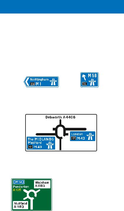
A road other than a motorway is called an “all purpose road”. At the point where you join a motorway, a special symbol is used to indicate the start of motorway regulations. A direction sign on an all purpose road will normally use this symbol to indicate a
motorway slip road or the beginning of a motorway. Where a sign shows a motorway route number on a blue background without the symbol, the route indicated will normally be an all purpose road that you should follow to reach the motorway.
Blue direction signs, with the motorway symbol and large route numbers, indicate that a motorway or motorway slip road leads directly from a junction with an all-purpose road. The motorway junction number, shown on the black background, may not always be included
On the approach to a junction with a motorway, a direction sign on an all-purpose road has blue panels that include the motorway symbol. The panels may include the junction number on a black background. The name in capital letters is a regional destination
This sign, with the motorway number in brackets on a blue background, but without the motorway symbol, indicates the route to take from a junction ahead in order to reach the motorway. The motorway is not accessed directly from this junction
78
motorway signs, signals and road markings
Signs for junctions on the motorway
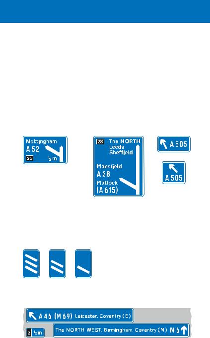
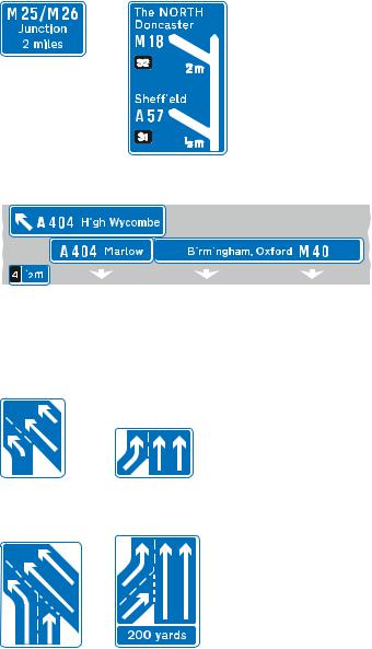
On the approach to a junction, direction signs are usually located 1 mile and 1⁄2 mile in advance, and at the exit point. Where junctions are close together, these distances may be reduced, normally to 2⁄3 mile and 1⁄3 mile respectively. The signs may be mounted at the side of the road or overhead.
Signs located at the side of the motorway. These are used where there is a deceleration lane. The number of lanes through the junction remains the same
The first two signs on the approach to a junction show the destination and the route number for the exit only. The distance shown (usually 1 mile or ½ mile) is the distance to the exit (start of the deceleration lane). The junction number is shown on the black background
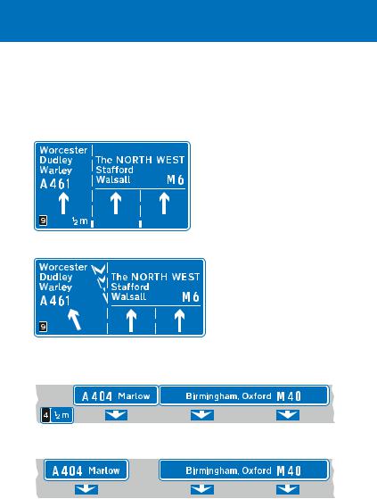
This sign is located at the start of the deceleration lane and includes destinations reached by staying on the motorway
A final route direction sign is usually located where the exit slip road separates from the main carriageway
Countdown markers indicate the distance to the start of the deceleration lane. Each bar represents about 100 yards
Overhead sign for junctions with deceleration lanes, where the number of lanes through the junction remains the same
This sign is used on the approach to the junction (usually 1 mile and
½ mile in advance) and at the start of the deceleration lane. Destinations and route numbers are shown for both the exit and the motorway ahead. Countdown markers are normally provided for the deceleration lane
79
Signs located at the side of the motorway where one or more lanes leave the main carriageway to become the exit slip road. This type of junction is known as a lane drop
This sign is normally located 1 mile and ½ mile before the junction and shows the appropriate lanes to use for various destinations. In this example, the left-hand lane leads directly to the exit slip road; the centre and right-hand lanes continue through the junction
This sign, with the inclined arrow, is normally located just before the left-hand lane leaves the main carriageway
Overhead signs for a lane-drop junction
This sign is used both in advance and at the junction
A confirmatory sign may be provided just after the point where the slip road has separated from the main carriageway. It is used where signs on the approach to the junction are either overhead or located at the side of the motorway
Lane-drop junctions do not use the countdown markers shown on page 79, as there is no deceleration lane for drivers to move into. A special road marking is used at lane drops (see pages 65 and 81) between the main carriageway and the lane that leads to the exit slip road. This marking usually commences at the ½ mile advance sign.
80
motorway signs, signals and road markings
Some junction layouts may be more complex and designed to allow a heavier flow of traffic to leave the motorway. A traffic lane may be shared by traffic both continuing ahead and leaving the motorway. This shared lane has a deceleration lane separated from a lane drop by chevron road markings. In the example, the left hand lane is used for the exit slip road only, the centre lane is the shared lane, and
the right hand lane is for ahead traffic only. A sign mounted at the side of the motorway shows the road layout. An overhead sign shows the appropriate lanes to use for each destination.
A sign mounted at the side of the motorway shows the arrangement of traffic lanes
Central reservation
Overhead sign showing appropriate lanes for the different destinations
81
|
|
|
|
|
|
|
|
|
|
|
|
Other types of sign in advance of junctions |
|
|
|
||||||||
|
|
|
|
|
|
|
|
|
Where two junctions are |
||
|
|
|
|
|
|
|
|
|
very close, they may |
||
|
|
|
|
|
|
|
|
|
both be shown on the |
||
|
|
|
|
|
|
|
|
|
same sign, together with |
||
|
|
|
|
|
|
|
|
|
the distances and |
||
Where the junction |
junction numbers. The |
||||||||||
ahead is with |
sign that is located |
||||||||||
another motorway, |
|
|
|
|
|
|
where the deceleration |
||||
|
|||||||||||
additional signs |
lane starts for the first |
||||||||||
may be provided |
exit (see page 79) will |
||||||||||
prior to the 1 mile |
normally show the |
||||||||||
advance sign |
second exit place names |
||||||||||
|
|
|
|
|
|
|
|
|
and route number with |
||
|
|
|
|
|
|
|
|
|
the ahead destinations |
||
|
|
|
|
|
|
|
|
|
|
|
|
|
|
|
|
|
|
|
|
|
|
|
|
|
|
|
|
|
|
|
|
|
|
|
|
|
|
|
|
|
|
|
|
|
|
|
|
|
|
|
|
|
|
|
|
|
|
|
|
|
|
|
|
|
|
|
|
|
|
|
|
This overhead sign indicates a junction that has two exits. The first exit has a deceleration lane and is indicated by the upper part of the sign. The second exit is a lane drop. Traffic continuing along the motorway should use the centre and right-hand lanes
Signs showing lanes that join the main carriageway at junctions
|
|
|
|
Sign for drivers |
Sign for drivers on |
||
on slip road |
main carriageway |
||
Sign for drivers |
Sign for drivers on |
on slip road |
main carriageway |
The slip road joins the main carriageway as a lane gain to increase the number of lanes from two to three.
A distance panel may be added
The right-hand lane of the slip road joins the main carriageway as a merge with an acceleration lane. This is followed by the left-hand lane which joins the main carriageway as a lane gain. Chevron road markings normally separate the two lanes on the slip road. The distance may be omitted
82
motorway signs, signals and road markings
Direction signs on exit slip roads (the green panels indicate a primary route; the white panels indicate a non-primary route)
Directions from junction ahead, usually controlled by traffic signals or a “give way” sign
Motorway-to-motorway junction with a roundabout (motorway regulations continue to apply)
Directions from a roundabout ahead
Appropriate lanes to use on the approach to the junction (sign located at the side of the slip road)
|
|
|
|
|
|
|
|
Appropriate lanes to use on the approach to |
Appropriate lanes for |
||||||
the junction (overhead sign over the slip road) |
turning movements |
||||||
|
|
|
|
|
|
|
at junction ahead |
|
|
|
|
|
|
|
Direction signs where |
|
|
|
|
|
|
|
the main carriageway |
|
|
|
|
|
|
|
of a motorway ends at |
|
|
|
|
|
|
|
a roundabout |
|
|
|
|
|
|
|
Motorway ends at a |
|
|
|
|
|
|
|
junction with an |
|
|
|
|
|
|
|
|
|
|
|
|
|
|
|
all-purpose road |
|
|
|
|
|
|
|
Motorway ends at a |
|
|
|
|
|
|
|
junction with another |
|
|
|
|
|
|
|
motorway |
83
Signs for tourist destinations
Tourist destinations are shown on signs with brown backgrounds. On the main carriageway of a motorway, these are separate from the main direction signs and are usually sited 3⁄4 mile and
1⁄4 mile from the junction (although they do not show the distance to the junction). On exit slip roads and where the motorway ends at a roundabout, the main direction signs may show tourist destinations on a brown panel, in the same way that they show other destinations on green and white panels (see page 83). However, separate brown signs are likely to be used at these locations to avoid putting too much information on a single sign. See pages 100 to 102 for more information about tourist signs.
Sign at the side of the main carriageway. There will usually be two of these in advance of the junction
Sign on exit slip road indicating directions to tourist attractions from a roundabout ahead
Sign indicating a place with several tourist attractions. It is located at the side of the main carriageway on the approach to a junction
Sign on exit slip road indicating directions to tourist attractions from a junction ahead
Where it is not practicable to provide tourist destination signs within 1 mile of a junction or there are more destinations than can be accommodated on the signs, this sign may
be used in advance of the main 1 mile direction sign for the junction. It may also be used when the junction layout is complex (such as that shown on page 81); “leave at Junction 24”
is then varied to “follow” plus a destination
84
motorway signs, signals and road markings
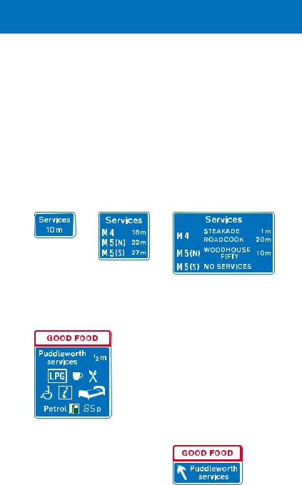
Signs for motorway service areas
On most motorways, service areas are provided at intervals of not more than 30 miles, half an hour at normal motorway driving speeds. These service areas are open 24 hours a day, every day of the year, and provide fuel, free parking (up to 2 hours), refreshments, toilets and disabled access. Other facilities, including telephones, motels and tourist information, may also be provided. Some motorway service areas are accessed directly from the main carriageway, others via junctions with other roads, where they will also be available to non motorway traffic.
After each junction, a sign may show the distance to the next motorway service area
This sign may be used when there is a junction with another motorway before the next service area
About ½ mile before the service area (further if the services are at a junction), a sign informs drivers of the facilities available, and may include both the name of the operator and the geographical name. The price of fuel, if shown, is usually for a litre of unleaded petrol, indicated by the green pump symbol. The “LPG” symbol means that LPG fuel is available; the “i” symbol refers to an information point; the bed symbol indicates overnight accommodation
About 1 mile in advance of a service area, a sign may inform drivers of the availability of services ahead, including the names of the operators. It will normally show the next two services, and include services on other motorways if the junctions with those motorways are reached before the second service area. Where the first services are located at a junction, this sign is likely to be used about 2 miles in advance; the word “Services” may be added to the junction direction signs as an exit destination
Sign located at start of the deceleration lane for a service area with direct access from the motorway
85
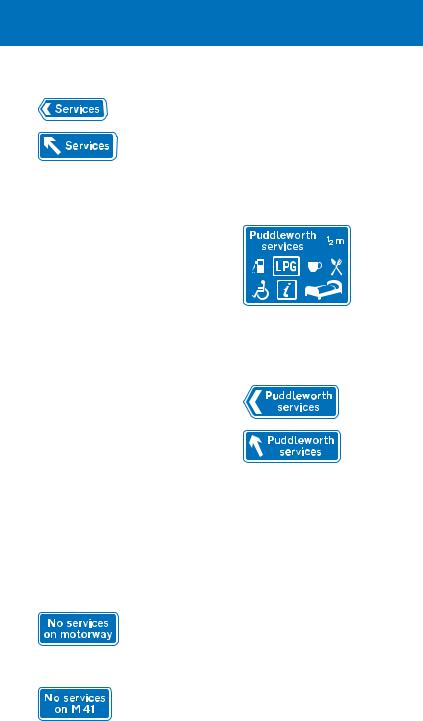
Alternative signs indicating the entrance to a service area accessed directly from a motorway. May be used to indicate the direction to a motorway service area located on an all-purpose road
Where a motorway service area is situated on an all purpose road, the signs off the motorway, indicating the services, should have a blue background (older signs may have a green or white background). The geographical name of the services may be shown on these signs, but not the operator’s name (this is shown only on the signs on the motorway). The word “Services” may be incorporated into other direction signs, including the sign on the exit slip road from the motorway. Where these signs have a green or white background, the word “Services” (with or without a geographical name) will normally be placed on a blue panel.
Motorway service area ahead on an all-purpose road (sign located off the motorway)
Direction or entrance to a motorway service area located on an all-purpose road (alternative signs)
Signs may be provided to indicate that services are not available on the motorway.
Sign on motorway indicating that no services are available ahead. Drivers should leave the motorway if service facilities are required
Sign on all-purpose road indicating that no services are available on motorway ahead. The motorway number may include a compass point (e.g. “M 41(N)”) if services are available in one direction but not the other
86
motorway signs, signals and road markings
Other signs on motorways
A route confirmatory sign is provided after most junctions. This shows the motorway number and the distances to the main destinations ahead
Where there are more destinations than can be accommodated on the direction signs at a junction, a sign such as this may be used in advance of the 1 mile direction sign. It advises drivers of the route to be followed (or junction to leave at) for destinations that cannot be accommodated on the main junction sign
This sign indicates a slip road that leads to a maintenance compound and is not available to the general public
Where a motorway has been widened but the original bridges retained, there may be no hard shoulder under or over the bridge. Where this occurs, signs will indicate the distance over which this applies. There will be hatched markings on the hard shoulder at the point where it comes to an end
Observation platforms are sometimes provided at the back of the hard shoulder. These are reserved for authorised vehicles, such as those of the Highways Agency's Traffic Officers or the police
County boundary sign (may be varied to show the name of a river)
Marker posts, located at the back of the hard shoulder at 100 metre intervals, show the direction to the nearest emergency telephone (housed in an orange box). You can use the telephone to contact the control centre in case of an emergency or breakdown
87
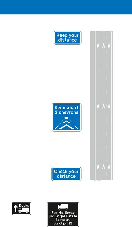
Some motorways may have special chevron markings in the centre of the traffic lanes. These are spaced 40 metres apart, and keeping two marks between your vehicle and the one in front will provide a safe driving distance at 70 mph. There will be signs advising you to check your distance, keep two chevrons apart and keep your distance.
Central reservation
Direction signs for drivers of goods vehicles
Direction of route recommended for goods vehicles
This sign is located before the 1 mile advance sign for a junction ahead. It is used where it is not practicable to sign a goods vehicle route at the junction itself
88
motorway signs, signals and road markings
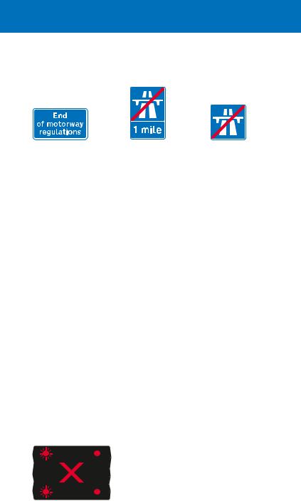
Signs indicating the end of motorway regulations
Sign located at the entrance to a service area accessed directly from the motorway, or a maintenance compound
Sign located on main carriageway to indicate the distance to the end of the motorway
Sign located where the motorway ends on either the main carriageway or exit slip road
Motorway signals and variable signs
These advise of abnormal traffic conditions ahead (e.g. lane closures or fog) and may indicate a speed limit. See Active Traffic Management on page 91 for signs where the hard shoulder is sometimes used as a traffic lane. Where variable speed limit signs are mounted over individual lanes and the speed limit is shown in a red ring (see page 20), the limit is mandatory. Speed limits that do not include the red ring are the maximum speeds advised for the prevailing conditions.
Signals and variable signs may apply to individual lanes when mounted overhead or, when located on the central reservation or at the side of the motorway, to the whole carriageway. They are normally blank, but when they indicate a restriction the reason may not always be obvious. There may have been an accident ahead, so take no chances and obey the signals. When red lamps are flashing above your lane, you MUST STOP unless you can move safely to a lane where red signals are not showing.
Red lamps flashing from side to side in pairs, together with a red cross, mean “do not proceed in the traffic lane directly below”. These signals are mounted above the carriageway: there is a signal for each
traffic lane. A previous signal may direct you into an adjacent lane (see page 90). More than one lane may be closed to traffic
89
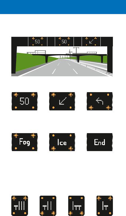
Signals and variable signs above each lane of the motorway
Each lane has its own signal; each signal has two pairs of amber lamps that flash from top to bottom. You sh ould obey the signal for your lane
Temporary maximum |
Move to adjacent |
Leave motorway |
speed advised for |
lane (arrow may |
at next exit |
prevailing traffic |
point downwards |
|
conditions |
to the right) |
|
Risk of fog ahead |
Risk of ice ahead |
End of temporary |
|
|
restrictions |
Signals and variable signs at the side of the motorway
These apply to the carriageway as a whole and are either located on the central reservation or mounted above the hard shoulder in combination with variable signs that display information about road works, congestion and diversions ahead. The amber lamps flash in pairs from top to bottom
Various lane closures (signs for carriageways with four, three or two lanes)
90
motorway signs, signals and road markings
Temporary |
Leave |
Risk of |
Risk of |
End of |
maximum |
motorway |
fog ahead |
ice ahead |
temporary |
speed |
at next exit |
|
|
restrictions |
advised |
|
|
|
|
Signals and variable signs at the entrance to a motorway
All lanes closed (signs for carriageways with four, three or two lanes). Do not enter the motorway when the red lamps are flashing in pairs from side to side
Older type of motorway signal
On some motorways, particularly in Scotland, you may encounter this type of signal mounted at the side of the carriageway. Flashing amber lamps indicate that there is a hazard ahead. You should not exceed a speed of 30 mph until you have passed this hazard
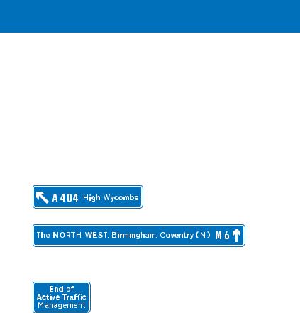
Active Traffic Management
Start of Active
Traffic Management
A scheme has been introduced on part of the M 42 motorway, between the M 6 and M 40 near Birmingham, to allow traffic to use the hard shoulder as a traffic lane during times of heavy congestion or when
there has been an incident that blocks one or more lanes. This is known as “Active Traffic Management”.
91
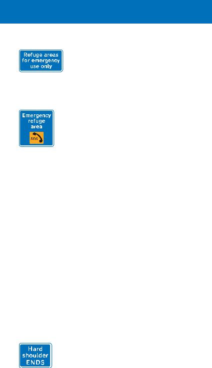
Sign indicating presence of emergency refuge areas ahead
This sign is located at each emergency refuge area
Lay bys, with emergency telephones, have been constructed at the back of the hard shoulder. These are known as “emergency refuge areas” and should be used in the same way as a normal hard shoulder. Even if the hard shoulder is not being used as a traffic lane, in the event of a breakdown or emergency you should use the refuge areas whenever possible. They are provided at intervals of approximately 500 metres (550 yards). Emergency refuge areas may be provided elsewhere on the motorway network at locations where there are no hard shoulders.
Each lane, including the hard shoulder, has overhead signals and signs similar to those described on pages 89 and 90. Before the hard shoulder is made available to traffic, a speed limit will be applied to the main carriageway. This will be the same for all lanes and will usually be 50 mph. The speed limit shown over each lane will be in a red ring (see page 20) with no signals. There will be a red cross, with no signals, above the hard shoulder to indicate that it is closed. When the hard shoulder is in use as a traffic lane, the red cross will change to a speed limit (the same as for the other lanes). Should it be necessary to close any lane, including the hard shoulder when it is in use as a traffic lane, a red cross with red lamps flashing in vertical pairs will be shown above that lane (see page 89). The previous signal will show an arrow, inclined downwards to the left or to the right, indicating that you should move into the adjacent lane (see page 90).
A variable message sign, located above the hard shoulder, will give worded messages such as “Congestion Stay in lane” and “Congestion Use hard shoulder”.
At intermediate junctions, the hard shoulder becomes the exit lane leading directly to the slip road. A sign indicates where this change of use takes place. If the hard shoulder is not already in
92
motorway signs, signals and road markings
use as a traffic lane, you can move across to leave the motorway when you have passed the sign. When the hard shoulder is in use as a traffic lane, it should normally be used only by traffic leaving at the next junction, as it becomes a lane drop at the junction (i.e. the lane becomes the exit slip road). The overhead direction signs are slightly different from those on other motorways. Signs
in advance of the junction showing the exit destinations and those showing the ahead destinations are usually mounted overhead at separate locations.
Destination reached by leaving the motorway at the next junction
Destinations reached by staying on the motorway at the next junction
The end of Active Traffic Management is indicated by a sign, and the overhead variable signs indicate the resumption of the national speed limit (see page 20).
Visit www.highways.gov.uk/atm for further information on Active Traffic Management.
93
Direction signs on all purpose roads
Junction ahead between two primary routes
Junction ahead between two non-primary routes
Roads other than motorways are referred to as all purpose roads. Those of national and regional importance are called primary routes: they always have “A” numbers. Direction signs on these roads have green backgrounds, yellow route numbers and white lettering. Primary routes, together with
motorways, form a national network of roads between major towns (primary destinations).
All other roads, including local roads with “A” numbers, are called non-primary routes. Direction signs on these roads have white backgrounds, with black route numbers and lettering. Most road maps show primary routes in green and use other colours to distinguish between non-primary “A” roads, “B” roads and local un numbered roads. Maps may also indicate primary destinations. The colour coding of these maps and the colours of the traffic signs may help you to plan your journey, using primary routes wherever possible.
Where a primary route has a junction with a non primary route, a coloured panel on the advance direction sign is used to indicate a route of different status. Blue panels are used to indicate motorways (see page 78), green panels indicate primary routes and white non primary routes.
Sign on a primary route indicating a non-primary route
Sign on a non-primary route indicating a primary route
94
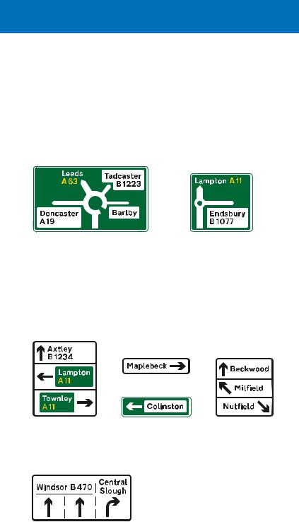
direction signs on all-purpose roads
There are different types of sign that might be used on the approach to a junction. A “map type” sign shows the junction layout and is commonly used for roundabouts, with a special symbol for mini roundabouts. The width of each route symbol depends on the type of the road indicated: wide for primary routes and motorways, medium for “A” and “B” numbered non primary routes and narrow for local roads without numbers.
Map-type sign on primary route |
Map-type sign for |
indicating a roundabout ahead |
a mini-roundabout |
A stack type sign shows directions at a junction ahead, but not the road layout. It can often be smaller than the equivalent
map type sign and is used for simple junctions (e.g. a crossroads) and where there might not be space for a larger sign, especially in urban areas.
Examples of stack-type signs. Arrows indicate the direction of exits from the junction ahead; each is shown on a separate part of the sign. The ahead direction may not be shown for a junction with a minor side road
A sign that indicates the appropriate lanes to use for turning movements at a junction ahead is sometimes used in conjunction with, or instead of, a map type or stack type sign.
95
Route numbers in brackets are roads that will be reached by following the
route indicated. Where a primary route is reached by following a non primary
route, its route number in brackets is
shown on a small green patch. However, non primary routes reached along primary routes are not indicated on
white patches. “B 1234” in the example is a non primary route. Signs indicating a route to a motorway include a blue patch with the motorway number in brackets.
Flag-type sign indicating a primary route that leads to a motorway and to a non-primary route
Rectangular sign at a junction, indicating both a primary and a non-primary route. The background colour of the main sign is that appropriate for the main road on which the sign is located
Signs located at a junction and pointing along a road have chevrons rather than arrows. They are called “flag type” signs. Some signs may be rectangular with upward pointing arrows. These are used where the road divides, such as at an exit slip road or a forked junction. The background colour of a flag type sign is that appropriate for the route indicated; coloured panels are not used where
a primary route has a junction with a non primary route. However, flag type signs may include route number patches. A rectangular sign at the junction may have coloured panels, but only if it indicates more than one route.
Flag-type sign indicating |
Rectangular sign at |
a junction, indicating |
|
a non-primary route |
a non-primary route |
This sign indicates that a U-turn should be made at a roundabout ahead in order to follow the route to the destinations shown. It is normally located on a dual carriageway road.
96
direction signs on all-purpose roads
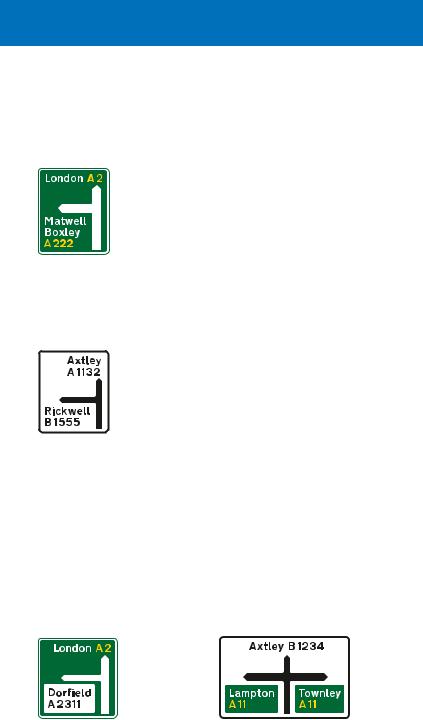
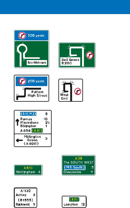
Direction sign showing distances to destinations
Route confirmatory sign
Route confirmatory sign: “Axtley” is on the current route; “Rickwell” is reached by turning onto the B 1555 at a junction ahead
Where a turning movement is prohibited, signs may show an alternative route.
A sign may indicate the distance to a destination in miles. Fractions of a mile may be shown for distances less than 3 miles. Signs may be provided after a junction listing destinations and distances: these are known as route confirmatory signs.
Route confirmatory sign including a regional destination (The SOUTH WEST) and the distance to a motorway
Route confirmatory sign on a non-primary route leading to a primary route. “Lampton” is reached by turning onto the A 11 at a junction ahead
97
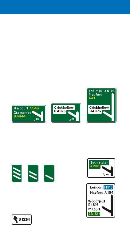
Some junctions on dual carriageway roads may be similar to those on motorways, where a slip road leaves the main carriageway via a deceleration lane or a lane drop. The first direction sign on the approach to the junction is usually located ½ mile in advance, although there may be an additional sign 1 mile before the junction. In some cases, these distances may be reduced, normally to
1⁄3 mile and 2⁄3 mile respectively. Another sign will be located where the deceleration lane starts or just before the left hand lane leaves the main carriageway as a lane drop. The signs may be mounted at the side of the road or overhead.
Signs located at the side of the road where there is a deceleration lane. The number of lanes through the junction remains the same
Where the junction ahead is between two primary routes, any non-primary route at the same junction is not shown on a white panel. Signs on the exit slip road will have green backgrounds
The junction ahead is with a non-primary route only, with the destination shown in a white panel. The signs on the exit slip road will have white backgrounds
This sign is located at the start of the deceleration lane. In addition to the side destination, the sign shows the ahead destinations
Countdown markers indicate the distance to the start of the deceleration lane. Each bar represents about 100 yards. These signs may also be used on the approach to a roundabout or crossroads. On non-primary routes, the bars are black on a white background
A final route direction sign |
|
|
|
|
|
is usually located where the |
Signs on a |
|
exit slip road separates from |
||
the main carriageway |
non-primary route |
|
98
direction signs on all-purpose roads
Overhead signs for junctions with deceleration lanes and slip roads, where the number of lanes through the junction remains the same
Primary route sign
Non-primary
route sign
Signs for a junction where a lane leaves the main carriageway to become the exit slip road. Primary route signs have green backgrounds. Non-primary route signs have white backgrounds
Signs mounted at the side of the carriageway in advance of the junction
Signs mounted at the side of the carriageway just before the left-hand lane leaves the main carriageway
Overhead
signs
99
Signs for tourist destinations
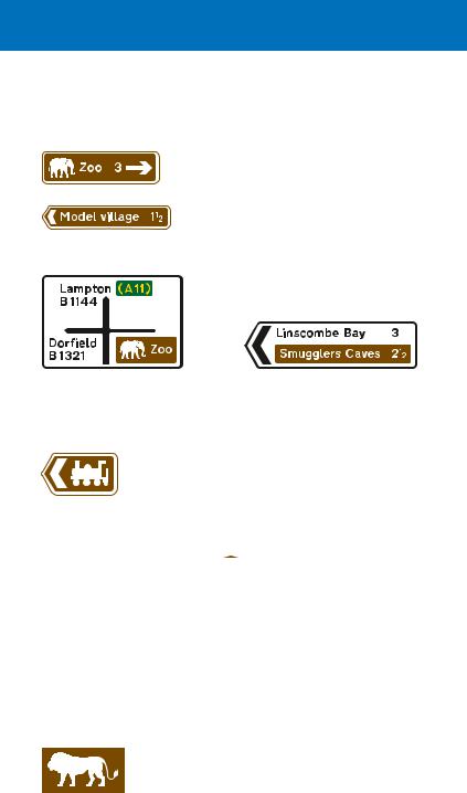
Tourist destinations may be shown on separate signs with brown backgrounds, or on brown panels incorporated into other direction signs. See page 84 for tourist destination signs on motorways.
Symbols are often used to indicate the type of destination. These may be shown on road maps. Once the full name of a tourist
destination and its symbol have been shown on a sign, subsequent signs may show only the associated symbol. Examples of symbols are shown below.
|
|
|
|
|
|
|
|
|
|
|
|
|
|
|
|
|
|
|
|
|
|
|
|
|
|
|
|
|
|
|
|
|
|
|
|
|
|
|
|
|
|
|
|
|
|
|
|
|
|
|
|
|
|
|
|
|
|
|
|
|
|
|
|
|
|
|
|
|
|
|
|
|
|
|
|
|
|
|
|
|
|
|
|
|
|
|
|
|
|
|
|
|
|
|
|
|
|
|
|
|
|
|
|
|
|
|
|
|
|
|
|
|
|
|
|
|
|
|
|
|
|
|
|
|
|
|
|
Tourist |
Castle |
|
|
|
Historic |
|
|
National |
|
|
English |
||||
information |
|
|
|
|
|
|
house |
|
|
Trust |
|
|
Heritage |
||
|
|
|
|
|
|
|
|
|
|
|
|
|
|
|
|
|
|
|
|
|
|
|
|
|
|
|
|
|
|
|
|
Theme park |
Country |
Bird |
|
Nature |
|
Farm park |
|
|
park |
garden |
|
reserve |
|
|
|
|
|
|
|
|
|
|
|
|
|
|
|
|
|
|
|
Safari park |
Beach |
Museum |
Roman |
Aviation |
|
|
(England) |
remains |
museum |
100
direction signs on all-purpose roads
There are also symbols for sports and leisure facilities.
|
|
|
Motor |
Golf |
Football |
Cricket |
Sports centre |
||
ground |
ground |
(England) |
sport |
course |
Race course |
Fishing |
Cycle hire |
Ten-pin |
Ski slope |
|
|
|
bowling |
|
See pages 103 and 104 for symbols and brown signs used for tourist facilities such as camp sites, restaurants and hotels. Some symbols are directional and face in the direction in which traffic turns at a junction. For ahead destinations, symbols generally face left. Some tourist attractions may use a general symbol, depending on whether they are in England, Scotland or Wales.
|
England |
|
Scotland |
|
|
|
Wales |
|
|
|
|
|
|
|
|
|
|
|
|
|
|
|
|
This sign is used in advance of a junction, advising drivers of the route to be followed where it is not practicable to sign a tourist destination at the junction itself
Direction signs may indicate a route through an area of special interest
Signs showing the distance ahead to a tourist attraction
101
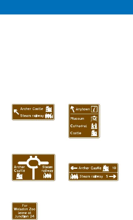
On the approach to a junction, a sign may indicate a town or geographical area with several tourist attractions.
Location of tourist information point or centre
Tourist information board (sign for pedestrians)
|
|
|
|
|
|
|
|
|
|
|
|
|
|
|
|
|
|
|
|
|
|
|
|
|
|
|
|
|
|
|
|
|
|
|
|
|
|
|
|
|
|
|
|
|
|
|
|
Direction to a tourist |
Direction to a parking |
||||||||||
information point or centre |
place associated with |
||||||||||
|
|
|
|
|
|
|
a tourist attraction |
||||
Services signs
See page 86 for blue background signs indicating motorway service areas located on all purpose roads. Services grouped together at a single location on primary and non-primary routes may be signed where parking, toilets, fuel and refreshments are available at least between 8 am and 8 pm on every day except Christmas Day, Boxing Day and New Year’s Day. Signs on non primary routes have white backgrounds. Older signs on primary routes have green backgrounds, but are being replaced by white background signs.
|
|
|
|
“not 24 hrs” may be varied |
|
|
|
|
to “Fuel only 24 hrs” or |
|
|
|
|
|
|
|
|
|
|
|
|
|
|
omitted if the services are |
|
|
|
|
open 24 hours every day. |
|
|
|
|
The cup symbol indicates |
|
|
|
|
that light refreshments are |
|
|
|
|
available. The wheelchair |
Distance to services |
Direction to |
symbol denotes facilities |
||
|
|
services |
for the disabled |
|
102
direction signs on all-purpose roads
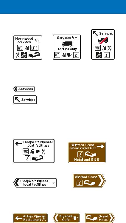
The services may have a geographical name. The “LPG” symbol means LPG fuel is available, the spoon and fork symbol denotes a restaurant and the bed symbol indicates overnight accommodation. The lorry symbol indicates that the services are for goods vehicles only. Where the symbol has a red bar, services are not available for goods vehicles
Alternative signs indicating the entrance to services. May be used to indicate the direction to services at a road junction
Where individual facilities are available in a small town or village off the main route, signs at the junction indicate the direction in which they are located. If tourist facilities are available, the signs have a brown background and may include some of the symbols shown on pages 100 and 101.
Signs on the approach to the junction
Signs located where traffic turns at the junction
Brown signs may indicate establishments that provide restaurant facilities, light refreshments or overnight accommodation.
103
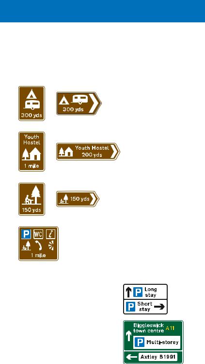
Licensed camping and caravan sites, youth hostels managed by the Youth Hostels Association or Scottish Youth Hostels Association, picnic areas, viewpoints and parking places with tourist information may also be indicated by brown signs.
Camping and caravan site: the tent or the caravan symbol may be omitted, depending on the facilities available. The name of the camp site may be shown
Youth hostel
Picnic area: may include a name
Distance to a parking place with toilets, tourist information, picnic area, telephone and viewpoint. The symbols may be varied as appropriate
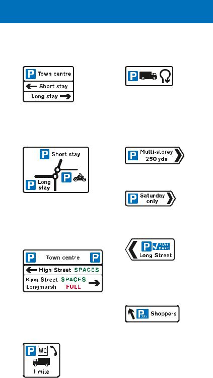
Parking signs
Direction signs indicating parking places, such as off street car parks, have white backgrounds, even on primary routes. Where the parking destination is incorporated into a primary route sign with a green background, it is shown on a
white panel.
104
direction signs on all-purpose roads
The signs may include various details about the parking places.
Where parking places in different directions are shown on a sign in advance of a junction, the “P” symbol may be shown at the top of the sign only
Where a parking place is for a particular class of vehicle, this may be shown by the appropriate symbol. This sign indicates a lorry park that is reached by making a U-turn at a roundabout ahead
Direction and distance to a multi-storey car park
This map-type sign indicates the direction of routes to parking places from a double mini-roundabout ahead. The route to the right leads to a parking place for solo motor cycles only
A variable message sign may indicate the availability of spaces at each parking place. Some signs may show the number of vacant spaces; these are updated at regular intervals throughout the day
Direction to a parking place that is available on certain days only
Direction to a parking place that has been approved by the police under the Safer Parking Scheme
Direction to a parking place showing the total number of spaces
Sign showing the facilities available at a parking place ahead. The lorry symbol is omitted where there is no restriction on the class of vehicle
105
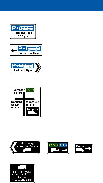
Signs may indicate the location of parking places associated with “Park and Ride” schemes. Where appropriate, the bus symbol
is changed to another form of transport, e.g. tram, national railway or London Underground. The sign may include the name of the Park and Ride site or the place that it serves. It may also include the times of operation. Other direction signs may incorporate the blue “Park and Ride” panel.
Signs for drivers of goods vehicles
Routes recommended for goods vehicles have black signs with a
white lorry symbol. Other direction signs may incorporate black lorry
route panels. The most suitable
route for lorries to a particular
destination may be different from
that for other vehicles. The lorry symbol faces in the direction in
which vehicles turn at a junction. For ahead destinations, the symbol generally faces left. Where route numbers for motorways and primary routes are shown, these are placed on blue and green patches respectively.
|
|
|
|
Direction sign at a junction |
Direction signs on the approach |
||
|
|
|
to a junction |
This sign is used in advance of a junction, advising drivers of goods vehicles of the route to be followed where it is not practicable to sign the route at the junction itself
106
direction signs on all-purpose roads
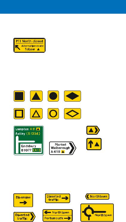
Signs for traffic diversions
Where, in an emergency, it is necessary to close a section of motorway or other
main road to traffic, a temporary sign may advise drivers to follow a diversion route. To help drivers navigate the route, black symbols on yellow patches may be permanently displayed on
existing direction signs, including motorway signs. On all purpose roads, the symbols may be used on separate signs with yellow backgrounds.
Symbols that may be used to indicate a diversion route
Signs incorporating a diversion route symbol that is shown alongside the road number of the route that drivers should follow
Separate signs indicating a diversion route (may be permanently displayed)
Temporary diversion signs may be required when a road is closed for reasons other than an emergency, e.g. to carry out works.
107
Examples of other direction signs
The name of the junction ahead may be shown at the top of the sign
Signs may incorporate hazard warning triangles. In this example there is an opening bridge on the road to the right
Signs may incorporate prohibitory roundels and indicate alternative routes
Direction signs at the junction may incorporate warning triangles or prohibitory roundels. A distance plate indicates that the hazard or restriction is not encountered immediately
A road through a by-passed town or village leads back to the main route
Staggered crossroads on a dual carriageway road: the white panel with the red border indicates a Ministry of Defence establishment
108
direction signs on all-purpose roads
Ministry of Defence establishments may also be shown on separate signs with red borders, arrows and chevrons. The background colour is always white, even on a primary route
Local destinations, including a railway station and recycling centre, reached along a primary route
These signs are used where there are more destinations than can be accommodated on the signs at a junction. They are located in advance of the first sign for the junction and advise drivers of the routes to be followed for particular destinations
This sign shows a local road with three junctions ahead in close proximity. The “H” symbol on a red patch indicates a hospital with “A & E” facilities (if there is no “A & E”, a blue patch is used). The “WC” and wheelchair symbols indicate toilets with facilities for disabled people
This sign shows both primary and local destinations that are reached along a primary route at a junction ahead. At some junctions, a separate sign might be used to indicate local destinations where this would avoid
putting too much information on a single sign. In this example, the sign indicates that the primary route is a ring road
Signs may indicate an alternative route
109
Direction to an airport. The aircraft symbol usually points in the same direction as the arrow, as shown
Direction to a car ferry. |
Direction to a |
|||
The car symbols are |
vehicle ferry. The |
|||
replaced by the words |
car symbol is |
|||
“Pedestrian ferry” |
replaced by a |
|||
when the ferry is for |
second lorry |
|||
foot passengers only |
symbol when the |
|||
|
ferry is for goods |
|||
|
vehicles only |
|||
|
|
|
|
|
|
|
|
|
|
|
|
|
|
|
|
|
|
|
|
This primary route sign indicates the directions to a ferry and an airport. It also shows a road to which entry is prohibited
Direction to a London Underground station
The route to the left has a priority lane that avoids the roundabout (see page 69 for road markings). The route to the right leads to town centre parking and a railway station
Direction to a VOSA (Vehicle & Operator Services Agency) testing station for goods vehicles
Direction to a |
|
|
|
|
|
|
|
|
|
|
|
|
|
|
|
|
|
|
|
|
|
|
|
|
|
|
|
|
|
|
|
Direction to |
Direction to a |
||||||
public telephone |
public toilets |
“Shopmobility” service |
|||||
|
with facilities for |
for disabled people |
|||||
|
disabled people |
|
|
|
|||
A modern version of the traditional fingerpost may be used at some junctions on minor rural roads. The sign may have a square end and may include a distance in miles. More than one destination may be shown
110
direction signs on all-purpose roads
Signs indicating the |
|
|
|
|
|
|
|
|
|
||||||||
Signs with a light |
|
|
|
|
|||||||||||||
direction to a new |
green background |
|
|
|
|
||||||||||||
housing development |
and yellow border |
Signs with a red |
|||||||||||||||
may be left in place |
are used to indicate |
||||||||||||||||
background are |
|||||||||||||||||
for up to six months |
the route for |
||||||||||||||||
used to indicate the |
|||||||||||||||||
after completion of |
emergency vehicles |
||||||||||||||||
route for emergency |
|||||||||||||||||
the development |
to a permanent |
||||||||||||||||
vehicles to a |
|||||||||||||||||
|
|
|
|
|
|
|
|
incident control |
|||||||||
|
|
|
|
|
|
|
|
temporary incident |
|||||||||
|
|
|
|
|
|
|
|
point |
|||||||||
|
|
|
|
|
|
|
|
control point |
|||||||||
|
|
|
|
|
|
|
|
|
|
|
|
|
|||||
|
|
|
|
|
|
|
|
|
|
|
|
|
|
|
|
|
|
|
|
|
|
|
|
|
|
|
|
|
|
|
|
|
|
|
|
|
|
|
|
|
|
|
|
|
|
|
|
|
|
|
|
|
|
|
|
|
|
|
|
|
|
|
|
|
|
|
|
|
|
|
|
|
|
|
|
|
|
|
|
|
|
|
|
|
|
|
|
|
|
|
|
|
|
|
|
|
|
|
|
|
|
|
|
|
|
|
|
|
|
|
|
|
|
|
|
|
|
|
|
|
|
|
|
|
|
|
|
|
|
|
|
|
|
|
|
|
|
|
|
|
|
|
|
|
|
|
|
|
|
|
|
|
|
|
|
|
|
|
|
|
|
Signs that indicate the appropriate traffic lanes for turning movements at a junction ahead may be used alone or in addition to map-type or stack-type advance direction signs. Signs on primary routes have green backgrounds, and signs on non-primary routes have white backgrounds
These signs show how traffic lanes on a slip road join the main carriageway of a dual carriageway road at junctions. Signs on primary routes have green backgrounds, and signs on non-primary route have white backgrounds
Sign for drivers |
Sign for drivers on |
on slip road |
main carriageway |
Sign for drivers |
Sign for drivers on |
on slip road |
main carriageway |
The slip road joins the main carriageway as a lane gain to increase the number of lanes from two to three.
A distance panel may be added
The right-hand lane of the slip road joins the main carriageway as a merge with an acceleration lane. This is followed by the left-hand lane, which joins the main carriageway as a lane gain. Chevron road markings normally separate the two lanes on the slip road. The distance may be omitted
111
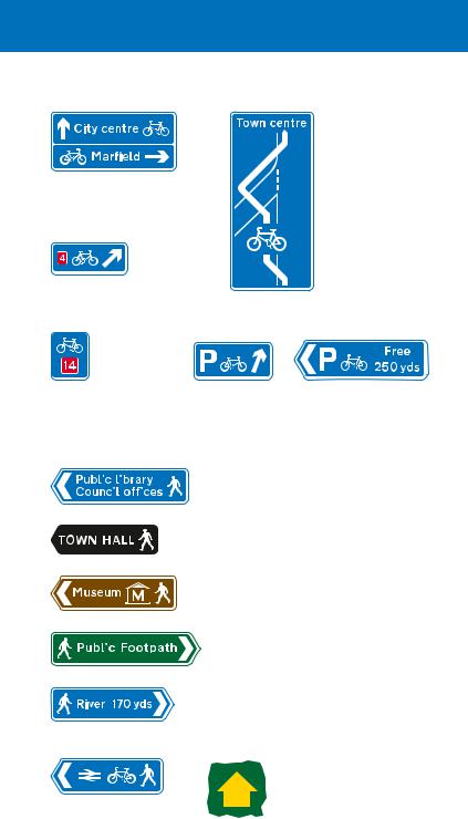
Direction signs for cyclists and pedestrians
Direction signs specifically for cyclists have a blue background and include a white pedal cycle symbol. Most are free standing signs, but some primary and non-primary route direction signs may incorporate a blue panel indicating a route for cyclists that is different from that for other traffic. The cycle symbol may also be used on pedestrian signs where cyclists and pedestrians share the route (see page 113).
Primary route direction sign, in advance of a junction, indicating a route for cyclists
Non-primary route direction sign, in advance of a junction, indicating a route for cyclists
Where the route indicated forms part of the National Cycle Network, the number of that route is shown on the signs in white numerals on a red patch. Links within the network may be designated as Regional Cycle Routes: signs indicating these have white route numbers on blue patches. Some local authorities may have their own numbered cycle routes using different coloured patches. Where a cycle route leads to a national or regional route, the number of the route to which it leads may be shown
in brackets. Signs may also include the name of the route.
Number of a national cycle route
Number of a regional cycle route
Sign showing the direction and distances (in miles) to destinations along a named cycle route forming part of the National Cycle Network
112
direction signs for cyclists and pedestrians
Sign indicating two different cycle routes leading from a junction ahead
Direction of a national cycle route
This sign informs you that you are following a national cycle route with the number shown
Map-type signs may indicate the route through a junction. In this example, the sign shows the route across an entry slip road. A sign may be used to direct cyclists to a signal-controlled crossing
Signs indicating the direction to a parking place for pedal cycles
|
|
|
|
|
|
|
|
|
|
|
Direction signs for pedestrians |
|
|
|
|
|
|
|
|
|
|
|
|
|
|
|
|
|
|
|
|
|
|
|
generally have a blue background |
|
|
|
|
|
|
|
|
|
|
|
|
|
|
|
|
|
|
|
|
|
|
|
|
|
|
|
|
|
|
|
|
|
|
|
with white lettering and include |
|
|
|
|
|
|
|
|
|
|
|
the walking figure symbol. In town |
|
|
|
|
|
|
|
|
|
|
|
centres, especially pedestrianised |
|
|
|
|
|
|
|
|
|
|
|
areas, other colours may be used |
|
|
|
|
|
|
|
|
|
|
|
and the symbol may be omitted; |
|
|
|
|
|
|
|
|
|
|
|
these signs may also use different |
|
|
|
|
|
|
|
|
|
|
|
styles of lettering. Pedestrian |
|
|
|
|
|
|
|
|
|
|
|
routes to tourist attractions may |
|
|
|
|
|
|
|
|
|
|
|
have brown backgrounds and |
|
|
|
|
|
|
|
|
|
|
|
|
|
|
|
|
|
|
|
|
|
|
|
those for public footpaths green |
|
|
|
|
|
|
|
|
|
|
|
backgrounds. Signs may include |
|
|
|
|
|
|
|
|
|
|
|
distances in yards or miles. |
|
|
|
|
|
|
|
|
|
|
|
A public footpath may be |
|
|
|
|
|
|
|
|
|
|
|
indicated by a yellow |
|
|
|
|
|
|
|
|
|
|
|
|
|
|
|
|
|
|
|
|
|
|
|
waymarker. A blue arrow is |
|
|
|
|
|
|
|
|
|
|
|
|
|
|
|
|
|
|
|
|
|
|
|
used for public bridleways. |
Pedestrian and cycle |
The background may be of |
||||||||||
route to a railway station |
a different colour |
||||||||||
113