

frequent video stores close to home. Similarly, prioritization of automobile service stations is useful if a suspect vehicle description has been obtained.
11.1.6 Motor Vehicle Registrations
A geographic profile can be integrated with suspect vehicle and offender descriptions to search registered motor vehicle and driver’s licence files, contained in provincial or state computer record systems. This is often done by first using the geoprofile to prioritize postal or zip codes most likely associated with the offender’s residence. The description and geographic parameters act as a linear program to produce a small set of records containing the appropriate data. This strategy results in areas of manageable size for major police investigations.
A case example involving a violent child sex offender illustrates this point. The postal codes for the neighbourhood within which he was attacking children were prioritized from the geoprofile. Planning and zoning maps were then used to eliminate industrial, commercial, and other nonresidential areas. Socioeconomic and demographic census data were also consulted to reevaluate the priority of those neighbourhoods that were inconsistent with the socioeconomic level of the offender as suggested by the criminal profile.
The final list of postal codes, ranked by priority of probability, could then be used to conduct a computer search of the provincial motor vehicle department records which contain postal codes as part of the address associated with the vehicle registered owner and driver’s licence files. Suspect vehicle and offender descriptions had been developed by detectives, and this information was combined with the geographic data to effectively focus the search.
For example, a new red station wagon driven by a tall white middle-aged male, with dark hair, may seem to be somewhat vague information. But the description actually contains several parameters: (1) vehicle style — station wagon; (2) vehicle colour — red; and (3) vehicle year range — last 5 years. Additional focus results from the various driver descriptors (e.g., sex, race, age range, height, hair colour, etc.), though the assumption that the driver is the vehicle’s registered owner may be incorrect. These parameters can narrow down hundreds of thousands of records to a few dozen vehicles or drivers when combined with a prioritized list of postal or zip codes. This is sufficient discrimination to allow detailed police follow-up (see Ressler & Shachtman, 1992, for an example of a murder investigation involving a computerized vehicle search without such geographic discrimination).
11.1.7 Patrol Saturation and Stakeouts
The geoprofile can be used as the basis for directing saturation patrol and police stakeouts. This strategy is particularly effective if the crimes occur
© 2000 by CRC Press LLC
during specific time periods. Many criminals spend a significant amount of time searching for targets, while others wait in particular areas for suitable victims and the right circumstances. Police have a much greater chance of observing an offender prowling or loitering than in an assault simply because considerable more time is spent hunting than attacking. It has been estimated that some criminals exhibit hunt to attack ratios in excess of 10:1.
Kentucky police, correctly anticipating the movements of a serial killer from the pattern of his crimes, set up road blocks in a park to question late night motorists (Barrett, 1990). This tactic gathered over 2000 names for the purpose of cross-comparison with other investigative information. Through a geographic analysis of the crime sites in the Atlanta Child Murders, Dettlinger came to the conclusion the killer was commuting along certain city routes (Dettlinger & Prugh, 1983). But his suggestion that stakeouts be established at the crucial points in this spatial pattern went unheeded by police, and five more bodies would be dumped near these locations before Task Force officers staking out a Chattahoochee River bridge pulled over Wayne Williams.
11.1.8 Response Plans
Additional police responses in the event of a new crime may be developed with a geographic profile. Many criminals return home after committing a crime, and patrol units can be directed to the area of probable offender residence, in addition to responding to the crime scene. Particular attention should be paid to the most logical routes from the crime site to the high profile area, and to relevant major arterial streets, freeways, and off-ramps. Roadblocks may also be an option. This strategy is only appropriate for those cases in which there is no significant time delay in reporting of the crime. Depending on the size of the hunting area, the offender’s probable escape routine might also suggest possibilities for locating witnesses. Gasoline stations, cafés, pubs, and other services along the likely routes between the crime sites and the peak geoprofile area can be identified and canvassed. Closed circuit television (CCTV) and commercial video cameras can similarly be checked.
In serial murder cases, police response plans can be developed in the event of the discovery of a new body dump site. Some killers reuse previous body dump sites; other offenders have been known to repeatedly visit their crime sites between killings for the purposes of fulfilling sexual fantasies. If the discovery of a new body dump site can be kept secret from the media, police surveillance may catch the offender revisiting the location.
© 2000 by CRC Press LLC
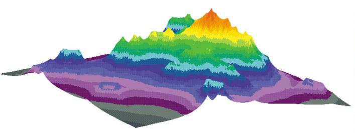
Chapter 10, Color Figure 1 Vancouver robberies—Jeopardy surface.
© 2000 by CRC Press LLC
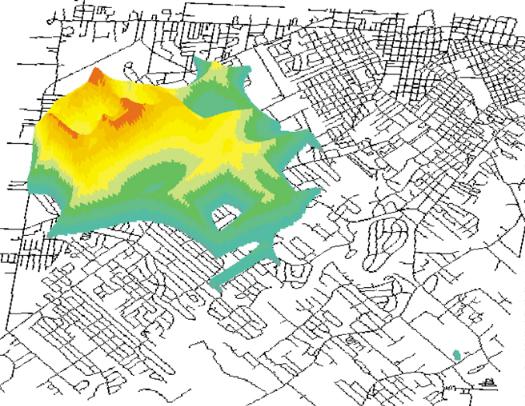
Chapter 10, Color Figure 2 Vancouver robberies—GeoProfile.
© 2000 by CRC Press LLC
Chapter 11, Color Figure 1 Lafayette South Side Rapist—Jeopardy surface.
© 2000 by CRC Press LLC
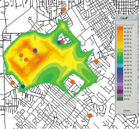
Chapter 11, Color Figure 2 Lafayette South Side Rapist—GeoProfile.
© 2000 by CRC Press LLC